
Mount Washiba
鷲羽岳
Toyama, Toyama · Elevation 2,924 m
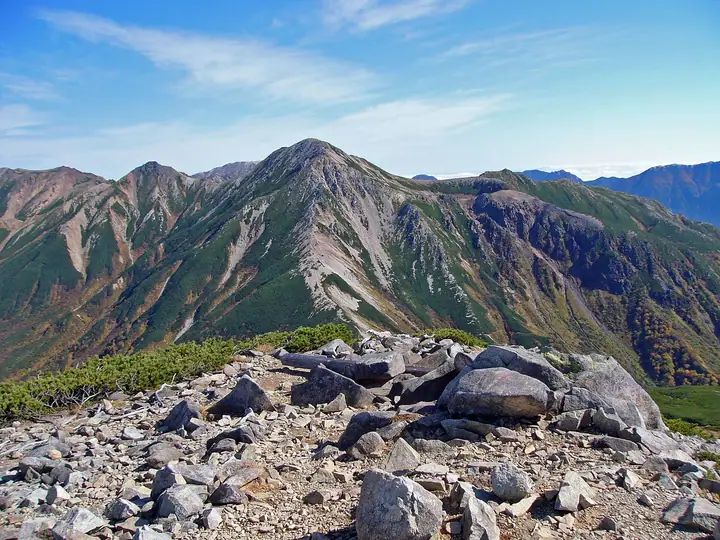
Mount Washiba is a 2,924 m peak on the boundary between Toyama City in Toyama and Ōmachi in Nagano, set in the Kurobe River headwaters at the centre of the Hida Mountains. Within Chūbu-Sangaku National Park, it is listed in Fukada Kyūya's Hyakumeizan and the Hyakkōzan. The name ("eagle wings") comes from the silhouette seen from neighboring Mitsumata-Renge, and the eastern flank holds Washiba-ike, a small crater lake at the head of Warimo-zawa. Climbed from Mitsumata-Sansō hut just below the summit, it is reached either from Shinhotaka Onsen via the Koike-Shindō and Sugoroku Hut, or from Oritate via Tarōdaira heading south, both multi-day approaches that mark Washiba as one of the most remote of the Northern Alps Hyakumeizan.
Mount Washiba at a glance
- Weather: The most settled day in the next 7 days is Wed, November 4: clear, gusts up to 10 m/s. Thu, Nov 5, Fri, Nov 6, Sat, Nov 7: strong wind (gusts up to 20 m/s).
- Route: The shortest is Mount Sugoroku, Mitsumatarenge, and Washiba Out-and-Back from Shinhotaka: about 20 h 39 min, 38.4 km, about 2,930 m of climbing.
Mount Washiba weather (hourly, 14 days)
Sunrise today 06:14, sunset 16:53
| Tue, 11/3 | Wed, 11/4 | Thu, 11/5 | Fri, 11/6 | Sat, 11/7 | Sun, 11/8 | Mon, 11/9 | Tue, 11/10 | Wed, 11/11 | Thu, 11/12 | Fri, 11/13 | Sat, 11/14 | Sun, 11/15 | Mon, 11/16 | Tue, 11/17 | |||||||||||||||||||||||||||||||||||||||||||||||||||||||||||||||||||||||
|---|---|---|---|---|---|---|---|---|---|---|---|---|---|---|---|---|---|---|---|---|---|---|---|---|---|---|---|---|---|---|---|---|---|---|---|---|---|---|---|---|---|---|---|---|---|---|---|---|---|---|---|---|---|---|---|---|---|---|---|---|---|---|---|---|---|---|---|---|---|---|---|---|---|---|---|---|---|---|---|---|---|---|---|---|---|
| Japan time | 15 | 17 | 19 | 21 | 23 | 1 | 3 | 5 | 7 | 9 | 11 | 13 | 15 | 18 | 21 | 0 | 3 | 6 | 9 | 12 | 15 | 18 | 21 | 0 | 3 | 6 | 9 | 12 | 15 | 18 | 21 | 0 | 3 | 6 | 9 | 12 | 15 | 18 | 21 | 0 | 3 | 6 | 9 | 12 | 15 | 18 | 21 | 0 | 3 | 6 | 9 | 15 | 21 | 3 | 9 | 15 | 21 | 3 | 9 | 15 | 21 | 3 | 9 | 15 | 21 | 3 | 9 | 15 | 21 | 3 | 9 | 15 | 21 | 3 | 9 | 15 | 21 | 3 | 9 | 15 | 21 | 3 | 9 | 15 | |
  |   | |  | | | | | | |  | |   |   |   | | | |   | |   | | | | | | |   | |   | |   | | |   | | | | |   |  | | | | | |   | | | | | | | | | | | | |   | |  | | | | |   |   | | | | | | | | | | | | | | | | | ||
| Temperature | °C | -2° | -7° | -9° | -9° | -9° | -8° | -7° | -7° | -6° | -1° | 2° | 3° | 2° | -3° | -2° | -2° | -2° | -1° | 0° | 2° | 4° | 0° | 0° | -1° | -1° | -1° | -1° | -1° | -2° | -5° | -7° | -8° | -10° | -11° | -11° | -10° | -11° | -14° | -15° | -15° | -15° | -12° | -5° | -3° | -5° | -9° | -8° | -8° | -8° | -8° | -6° | -6° | -15° | -14° | -6° | -6° | -8° | -14° | -11° | -10° | -12° | -14° | -5° | -5° | -13° | -8° | -8° | -7° | -12° | -11° | -2° | -1° | -10° | -9° | -2° | -2° | -3° | -3° | -1° | -5° | -10° | -10° | -4° | -3° |
| Precipitation | mm | 0.1 | 2.0 | 10 | 8 | 6 | 1.2 | 0.4 | 1.3 | 2.2 | 1.0 | 1.0 | 0.3 | 1.0 | 0.5 | 2.3 | 2.4 | 2.5 | 2.3 | 1.2 | 0.3 | 0.1 | 0.2 | 1.4 | 1.8 | 0.2 | 1.0 | 2.5 | 8 | 6 | 1.3 | 1.4 | 2.7 | 0.1 | 1.0 | 11 | 9 | 3.8 | 3.5 | 2.0 | |||||||||||||||||||||||||||||||||||||||||||||
| New snow | cm | 0.2 | 0.3 | 2.2 | 2.4 | 2.5 | 2.3 | 1.2 | 0.3 | <.1 | <.1 | <.1 | 0.2 | 1.4 | 1.6 | 0.2 | 1.0 | <.1 | <.1 | 2.5 | 7.2 | 5.7 | 1.3 | <.1 | 1.4 | 2.2 | 0.1 | <.1 | 1.3 | 1.7 | |||||||||||||||||||||||||||||||||||||||||||||||||||||||
| Snow depth | cm | 0 | 0 | 0 | 0 | 0 | 0 | 0 | 0 | 0 | 0 | 0 | 0 | 0 | 0 | 0 | 0 | 0 | 0 | 0 | 0 | 0 | 0 | 0 | 0 | 0 | 0 | 0 | 0 | 0 | 0 | <1 | 2 | 4 | 6 | 8 | 8 | 8 | 8 | 8 | 8 | 8 | 7 | 7 | 7 | 7 | 7 | 7 | 7 | 8 | 9 | 9 | 9 | 9 | 8 | 8 | 8 | 10 | 16 | 20 | 20 | 19 | 19 | 18 | 17 | 17 | 18 | 19 | 19 | 19 | 18 | 18 | 17 | 17 | 17 | 16 | 15 | 13 | 12 | 10 | 9 | 10 | 10 | 10 | 9 |
| Wind | m/s | 1 | 1 | 1 | 1 | 1 | 1 | 1 | 1 | 1 | 1 | 2 | 2 | 2 | 1 | 2 | 0 | 0 | 1 | 3 | 3 | 2 | 1 | 2 | 2 | 2 | 2 | 3 | 3 | 3 | 3 | 3 | 3 | 3 | 4 | 4 | 4 | 3 | 3 | 2 | 2 | 2 | 1 | 1 | 1 | 0 | 1 | 2 | 2 | 3 | 2 | 2 | 1 | 1 | 1 | 2 | 2 | 2 | 7 | 4 | 2 | 1 | 0 | 1 | 0 | 1 | 2 | 3 | 2 | 1 | 0 | 1 | 1 | 1 | 1 | 2 | 1 | 3 | 3 | 2 | 3 | 1 | 0 | 0 | 1 |
| Wind gusts | m/s | 10 | 8 | 9 | 9 | 9 | 8 | 7 | 7 | 7 | 8 | 9 | 10 | 10 | 10 | 11 | 11 | 8 | 9 | 14 | 18 | 16 | 12 | 11 | 13 | 13 | 13 | 14 | 15 | 19 | 16 | 16 | 16 | 17 | 18 | 19 | 20 | 20 | 17 | 15 | 14 | 14 | 14 | 12 | 9 | 9 | 11 | 12 | 13 | 15 | 15 | 13 | 12 | 7 | 8 | 10 | 14 | 14 | 27 | 30 | 20 | 13 | 7 | 9 | 11 | 8 | 12 | 12 | 12 | 11 | 10 | 7 | 7 | 8 | 9 | 11 | 14 | 18 | 19 | 15 | 15 | 15 | 8 | 5 | 7 |
| Wind dir. | ↓ | ↓ | ↓ | ↓ | ↓ | ↓ | ↓ | ↓ | ↓ | ↓ | ↓ | ↓ | ↓ | ↓ | ↓ | ↓ | ↓ | ↓ | ↓ | ↓ | ↓ | ↓ | ↓ | ↓ | ↓ | ↓ | ↓ | ↓ | ↓ | ↓ | ↓ | ↓ | ↓ | ↓ | ↓ | ↓ | ↓ | ↓ | ↓ | ↓ | ↓ | ↓ | ↓ | ↓ | ↓ | ↓ | ↓ | ↓ | ↓ | ↓ | ↓ | ↓ | ↓ | ↓ | ↓ | ↓ | ↓ | ↓ | ↓ | ↓ | ↓ | ↓ | ↓ | ↓ | ↓ | ↓ | ↓ | ↓ | ↓ | ↓ | ↓ | ↓ | ↓ | ↓ | ↓ | ↓ | ↓ | ↓ | ↓ | ↓ | ↓ | ↓ | ↓ | ↓ | |
Mount Washiba hiking routes
Hiking times are estimates calculated from the terrain.
Huts, campsites and lodging near Mount Washiba
Mountain huts
- Mitsumatasanso 2026: open July 4–October 15 · reservation required
- Suisho Hut 2026: open July 10–September 30 · reservation required · sleeps 38
- クロマメ小屋 unstaffed
- 雲ノ平山荘 2026: open July 1–October 15 · reservation required · sleeps 60
- Sugoroku Goya 2026: open July 10–October 20 · reservation required · sleeps 150
Campsites
- 三俣蓮華岳テント場
- 雲ノ平キャンプ場
- 双六小屋テント場
- 黒部五郎キャンプ場
Lists that include Mount Washiba
100 Famous Japanese Mountains · Japan 200 Famous Mountains · Japan's 300 Famous Mountains · Japan's 100 Highest Mountains · 100 Famous Hot Spring Mountains · Koshinetsu 100 Famous Mountains · Shinshu 100 Famous Mountains · 100 Mountains of Toyama · Shinshu Mountain Cards · Elevations of 1003 Mountains of Japan · 1000 Mountains of Japan
Mount Washiba facts
- Elevation
- 2,924 m
- Location
- Toyama, Toyama
36.403025, 137.605246 - National Park
- 中部山岳国立公園
- Website
- mitsumatasanso.com
- Trail Map
- www.pref.toyama.jp (PDF)
- Access Information
- kumonodaira.com
- Wikipedia
- ja.wikipedia.org