
Mount Tsubakuro
燕岳
Azumino, Nagano · Elevation 2,763 m
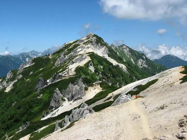
Mount Tsubakuro is a 2,763 m peak on the border between Azumino and Ōmachi in Nagano Prefecture, sitting within Chūbu-Sangaku National Park at the entrance to the famous Omote-Ginza traverse of the Northern Alps. The summit ridge is a striking white granite crest sprinkled with sculpted boulders such as Iruka-iwa and Megane-iwa and one of Japan's largest stands of komakusa wildflowers, giving the peak its nickname "Queen of the Northern Alps." It is listed in the Nihon Nihyaku Meizan, the Nihon Hyakkōzan, and many other major mountain lists. The standard route climbs from the Nakabusa Onsen trailhead up the Kassen-One ridge — one of the Northern Alps' three great steep ascents — to Enzansō hut and the summit; despite the steepness, the trail is well maintained by Enzansō with benches and water points along the way, and it is widely regarded as the classic Northern Alps introductory route.
Mount Tsubakuro at a glance
- Weather: The most settled day in the next 7 days is Wed, November 4: clear, gusts up to 8 m/s. Sat, Nov 7: strong wind (gusts up to 16 m/s).
- Route: The shortest is Mount Tsubakuro via Kassen Ridge from Nakabusa Onsen: about 7 h 44 min, 11.2 km, about 1,430 m of climbing.
Mount Tsubakuro weather (hourly, 14 days)
Sunrise today 06:13, sunset 16:52
| Tue, 11/3 | Wed, 11/4 | Thu, 11/5 | Fri, 11/6 | Sat, 11/7 | Sun, 11/8 | Mon, 11/9 | Tue, 11/10 | Wed, 11/11 | Thu, 11/12 | Fri, 11/13 | Sat, 11/14 | Sun, 11/15 | Mon, 11/16 | Tue, 11/17 | |||||||||||||||||||||||||||||||||||||||||||||||||||||||||||||||||||||||
|---|---|---|---|---|---|---|---|---|---|---|---|---|---|---|---|---|---|---|---|---|---|---|---|---|---|---|---|---|---|---|---|---|---|---|---|---|---|---|---|---|---|---|---|---|---|---|---|---|---|---|---|---|---|---|---|---|---|---|---|---|---|---|---|---|---|---|---|---|---|---|---|---|---|---|---|---|---|---|---|---|---|---|---|---|---|
| Japan time | 15 | 17 | 19 | 21 | 23 | 1 | 3 | 5 | 7 | 9 | 11 | 13 | 15 | 18 | 21 | 0 | 3 | 6 | 9 | 12 | 15 | 18 | 21 | 0 | 3 | 6 | 9 | 12 | 15 | 18 | 21 | 0 | 3 | 6 | 9 | 12 | 15 | 18 | 21 | 0 | 3 | 6 | 9 | 12 | 15 | 18 | 21 | 0 | 3 | 6 | 9 | 15 | 21 | 3 | 9 | 15 | 21 | 3 | 9 | 15 | 21 | 3 | 9 | 15 | 21 | 3 | 9 | 15 | 21 | 3 | 9 | 15 | 21 | 3 | 9 | 15 | 21 | 3 | 9 | 15 | 21 | 3 | 9 | 15 | |
  |   | |  | |   | | |   | |  | | |   |   | | | |   | |   | | | | | | |   |   | |   |   | |   |   | | | | |   | |  | | | | | | | | |   | | | | | | | | |   | | | | | | |   | | |  | | | | | | | | | | | | | | | ||
| Temperature | °C | 0° | -4° | -6° | -7° | -8° | -7° | -6° | -6° | -6° | -1° | 2° | 3° | 2° | -2° | -2° | -2° | -2° | -1° | 0° | 2° | 5° | 1° | 1° | 0° | 0° | 0° | 2° | 3° | 3° | -2° | -4° | -5° | -7° | -8° | -7° | -7° | -7° | -10° | -11° | -12° | -12° | -11° | -4° | -1° | -3° | -6° | -6° | -6° | -7° | -6° | -4° | -3° | -11° | -11° | -4° | -2° | -6° | -10° | -8° | -6° | -10° | -12° | -4° | -2° | -11° | -7° | -6° | -5° | -10° | -10° | -2° | 1° | -8° | -8° | 0° | 0° | -2° | -2° | 0° | -2° | -7° | -9° | -5° | -2° |
| Precipitation | mm | 0.7 | 0.4 | 0.4 | 0.1 | 2.1 | 10 | 8 | 7 | 1.5 | 0.4 | 0.6 | 0.9 | 2.8 | 0.5 | 1.0 | 0.3 | 0.2 | 1.1 | 1.6 | 1.5 | 1.4 | 0.7 | 0.1 | 0.1 | 0.1 | 1.1 | 1.5 | 0.3 | 3.6 | 4.2 | 3.4 | 0.2 | 0.1 | 1.3 | 5 | 3.9 | 0.7 | 0.5 | 1.0 | 0.2 | 0.7 | 10 | 10 | 1.6 | 2.1 | 2.2 | 1.0 | |||||||||||||||||||||||||||||||||||||
| New snow | cm | <.1 | 0.1 | 0.8 | 1.1 | 1.2 | 1.1 | 0.7 | 0.1 | <.1 | <.1 | <.1 | 0.1 | 0.8 | 1.0 | 0.1 | 0.4 | <.1 | 1.2 | 3.7 | 3.5 | 0.6 | <.1 | 0.5 | 0.7 | <.1 | 0.4 | 0.7 | |||||||||||||||||||||||||||||||||||||||||||||||||||||||||
| Snow depth | cm | 0 | 0 | 0 | 0 | 0 | 0 | 0 | 0 | 0 | 0 | 0 | 0 | 0 | 0 | 0 | 0 | 0 | 0 | 0 | 0 | 0 | 0 | 0 | 0 | 0 | 0 | 0 | 0 | 0 | 0 | <1 | <1 | 2 | 2 | 3 | 4 | 4 | 4 | 4 | 4 | 4 | 3 | 3 | 3 | 3 | 3 | 3 | 3 | 4 | 4 | 4 | 4 | 4 | 4 | 4 | 4 | 4 | 7 | 10 | 9 | 9 | 9 | 8 | 8 | 8 | 8 | 8 | 8 | 8 | 8 | 8 | 7 | 7 | 7 | 7 | 6 | 5 | 5 | 4 | 2 | 3 | 3 | 3 | 2 |
| Wind | m/s | 1 | 1 | 1 | 1 | 1 | 1 | 0 | 0 | 0 | 1 | 1 | 1 | 2 | 0 | 1 | 0 | 0 | 0 | 1 | 1 | 0 | 0 | 1 | 1 | 1 | 1 | 1 | 2 | 1 | 2 | 1 | 1 | 2 | 2 | 2 | 2 | 2 | 2 | 3 | 3 | 2 | 2 | 1 | 1 | 1 | 1 | 1 | 1 | 1 | 1 | 1 | 1 | 1 | 1 | 1 | 2 | 1 | 3 | 2 | 1 | 1 | 1 | 1 | 1 | 1 | 2 | 1 | 1 | 1 | 1 | 1 | 1 | 1 | 1 | 0 | 0 | 1 | 2 | 1 | 2 | 1 | 0 | 1 | 1 |
| Wind gusts | m/s | 8 | 7 | 7 | 7 | 7 | 6 | 6 | 5 | 5 | 7 | 8 | 8 | 8 | 7 | 7 | 7 | 5 | 5 | 9 | 12 | 11 | 8 | 6 | 8 | 8 | 8 | 10 | 12 | 14 | 10 | 10 | 10 | 12 | 13 | 14 | 16 | 15 | 13 | 12 | 12 | 12 | 11 | 10 | 9 | 9 | 9 | 8 | 8 | 9 | 9 | 9 | 9 | 7 | 6 | 7 | 12 | 11 | 20 | 22 | 17 | 10 | 5 | 7 | 9 | 10 | 8 | 9 | 11 | 9 | 7 | 6 | 6 | 7 | 6 | 7 | 10 | 10 | 12 | 11 | 13 | 12 | 7 | 5 | 6 |
| Wind dir. | ↓ | ↓ | ↓ | ↓ | ↓ | ↓ | ↓ | ↓ | ↓ | ↓ | ↓ | ↓ | ↓ | ↓ | ↓ | ↓ | ↓ | ↓ | ↓ | ↓ | ↓ | ↓ | ↓ | ↓ | ↓ | ↓ | ↓ | ↓ | ↓ | ↓ | ↓ | ↓ | ↓ | ↓ | ↓ | ↓ | ↓ | ↓ | ↓ | ↓ | ↓ | ↓ | ↓ | ↓ | ↓ | ↓ | ↓ | ↓ | ↓ | ↓ | ↓ | ↓ | ↓ | ↓ | ↓ | ↓ | ↓ | ↓ | ↓ | ↓ | ↓ | ↓ | ↓ | ↓ | ↓ | ↓ | ↓ | ↓ | ↓ | ↓ | ↓ | ↓ | ↓ | ↓ | ↓ | ↓ | ↓ | ↓ | ↓ | ↓ | ↓ | ↓ | ↓ | ↓ | |
Mount Tsubakuro hiking routes
- Mount Tsubakuro via Kassen Ridge from Nakabusa Onsen 11.2 km · Ascent 1,433 m 町営第一駐車場, 第二駐車場 (parking)
- Mount Tsubakuro, North Mount Tsubakuro, and Mount Otensho Return from Nakabusa Onsen 21.1 km · Ascent 2,168 m Tubakuro-dake Trailhead, 中房温泉のりば (Bus stop), 中房温泉駐車場
Hiking times are estimates calculated from the terrain.
Huts, campsites and lodging near Mount Tsubakuro
Mountain huts
- 燕山荘 2026: open April 25–November 22 · reservation required · sleeps 650
- 合戦小屋
- 湯俣山荘 2026: open July 18–November 7 · reservation required · sleeps 25
- Seiranso
- 晴嵐荘 湯俣温泉 2026: open July 17–October 18 · reservation required · sleeps 30
Campsites
- 燕山荘テント場
- 合戦小屋テント場
- 晴嵐荘テントサイト
- 餓鬼岳小屋
Lodging
- 中房温泉
- 安曇野市営有明荘
Lists that include Mount Tsubakuro
Japan 200 Famous Mountains · Japan's 300 Famous Mountains · Japan's 100 Highest Mountains · New Japan 100 Famous Mountains · 100 Famous Hot Spring Mountains · Koshinetsu 100 Famous Mountains · Tokai 100 Mountains · Shinshu 100 Famous Mountains · Shinshu Mountain Cards · Elevations of 1003 Mountains of Japan · 1000 Mountains of Japan
Mount Tsubakuro facts
- Elevation
- 2,763 m
- Location
- Azumino, Nagano
36.406859, 137.712770 - National Park
- 中部山岳国立公園
- Website
- www.enzanso.co.jp
- Trail Map
- www.enzanso.co.jp
- Access Information
- www.enzanso.co.jp
- Wikipedia
- ja.wikipedia.org