
Mount Otenshō
大天井岳
Azumino, Nagano · Elevation 2,922 m
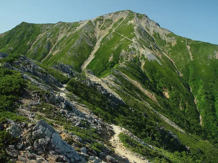
Mount Otenshō is a 2,922 m peak straddling Ōmachi, Azumino, and Matsumoto cities in Nagano Prefecture and is the highest summit of the Jōnen Range in the Hida (Northern Japanese) Alps. Set within Chūbu Sangaku National Park, it is also the highest point in Azumino City. The name is variously read otenshō or daitenjō and is said to derive from "otensho," a sacred high place, or from "daitenjō," simply "great heavens." Listed in the Nihon Nihyaku Meizan, the Nihon Hyaku Kōzan, and the Shinshū Hyakumeizan, the rocky summit marks the junction of the Omote-Ginza traverse (Tsubakuro – Otenshō – Nishi-yama – Yari) and the Jōnen Range traverse (Otenshō – Jōnen – Chōgatake) and offers a 360° panorama dominated by the Yari-Hotaka skyline. The standard ascent climbs the Gassen Ridge from Nakabusa Onsen via Enzansō and Tsubakuro to the ridge crest; Daitensō hut just below the summit (operated by the Enzansō group from mid-June to early November) anchors most multi-day plans.
Mount Otenshō at a glance
- Weather: The most settled day in the next 7 days is Wed, November 4: clear, gusts up to 7 m/s.
- Route: The shortest is Mount Tsubakuro, North Mount Tsubakuro, and Mount Otensho Return from Nakabusa Onsen: about 13 h 54 min, 21.1 km, about 2,170 m of climbing.
Mount Otenshō weather (hourly, 14 days)
Sunrise today 06:13, sunset 16:52
| Tue, 11/3 | Wed, 11/4 | Thu, 11/5 | Fri, 11/6 | Sat, 11/7 | Sun, 11/8 | Mon, 11/9 | Tue, 11/10 | Wed, 11/11 | Thu, 11/12 | Fri, 11/13 | Sat, 11/14 | Sun, 11/15 | Mon, 11/16 | Tue, 11/17 | |||||||||||||||||||||||||||||||||||||||||||||||||||||||||||||||||||||||
|---|---|---|---|---|---|---|---|---|---|---|---|---|---|---|---|---|---|---|---|---|---|---|---|---|---|---|---|---|---|---|---|---|---|---|---|---|---|---|---|---|---|---|---|---|---|---|---|---|---|---|---|---|---|---|---|---|---|---|---|---|---|---|---|---|---|---|---|---|---|---|---|---|---|---|---|---|---|---|---|---|---|---|---|---|---|
| Japan time | 15 | 17 | 19 | 21 | 23 | 1 | 3 | 5 | 7 | 9 | 11 | 13 | 15 | 18 | 21 | 0 | 3 | 6 | 9 | 12 | 15 | 18 | 21 | 0 | 3 | 6 | 9 | 12 | 15 | 18 | 21 | 0 | 3 | 6 | 9 | 12 | 15 | 18 | 21 | 0 | 3 | 6 | 9 | 12 | 15 | 18 | 21 | 0 | 3 | 6 | 9 | 15 | 21 | 3 | 9 | 15 | 21 | 3 | 9 | 15 | 21 | 3 | 9 | 15 | 21 | 3 | 9 | 15 | 21 | 3 | 9 | 15 | 21 | 3 | 9 | 15 | 21 | 3 | 9 | 15 | 21 | 3 | 9 | 15 | |
  |   |  | | | | | |   | |  | | |   | |   | | |   | |   |   | | | | |   | | | | |   | |   |   |   | | | | |  | | | | | | |   | | | | | | | |   | | | |   | |  | | | | | | | | | | | | | | | | | |   |   |   | | | ||
| Temperature | °C | 1° | -3° | -5° | -6° | -6° | -6° | -5° | -5° | -4° | 0° | 2° | 4° | 3° | -1° | -1° | -1° | -1° | 0° | 1° | 3° | 6° | 1° | 2° | 1° | 1° | 1° | 3° | 5° | 3° | -1° | -3° | -4° | -6° | -6° | -6° | -5° | -5° | -8° | -10° | -10° | -9° | -9° | -3° | 1° | -2° | -5° | -5° | -5° | -5° | -5° | -2° | -1° | -10° | -11° | -3° | -1° | -5° | -9° | -7° | -5° | -10° | -10° | -4° | -2° | -10° | -6° | -4° | -3° | -8° | -8° | -2° | 2° | -6° | -7° | 1° | 1° | -1° | -1° | 2° | 1° | -5° | -7° | -4° | -1° |
| Precipitation | mm | 0.2 | 2.4 | 10 | 9 | 7 | 1.1 | 0.1 | 1.0 | 1.4 | 0.3 | 0.2 | 0.3 | 0.6 | 0.7 | 0.6 | 0.3 | 0.5 | 0.7 | 0.1 | 1.4 | 4.0 | 2.3 | 0.2 | 0.4 | 0.2 | 0.6 | 9 | 11 | 1.4 | 0.5 | 0.9 | 0.5 | ||||||||||||||||||||||||||||||||||||||||||||||||||||
| New snow | cm | <.1 | <.1 | <.1 | <.1 | 0.2 | 0.5 | 0.7 | 0.6 | 0.3 | <.1 | <.1 | <.1 | <.1 | <.1 | 0.4 | 0.4 | <.1 | <.1 | <.1 | 0.7 | 2.9 | 2.2 | <.1 | 0.1 | 0.1 | <.1 | <.1 | <.1 | <.1 | <.1 | ||||||||||||||||||||||||||||||||||||||||||||||||||||||
| Snow depth | cm | 0 | 0 | 0 | 0 | 0 | 0 | 0 | 0 | 0 | 0 | 0 | 0 | 0 | 0 | 0 | 0 | 0 | 0 | 0 | 0 | 0 | 0 | 0 | 0 | 0 | 0 | 0 | 0 | 0 | 0 | 0 | <1 | <1 | <1 | 1 | 1 | <1 | <1 | <1 | <1 | <1 | <1 | <1 | <1 | <1 | <1 | <1 | <1 | <1 | <1 | <1 | <1 | <1 | <1 | <1 | <1 | 1 | 3 | 5 | 4 | 4 | 4 | 4 | 3 | 3 | 3 | 3 | 2 | 2 | 2 | 2 | 2 | 2 | 2 | 1 | 1 | <1 | <1 | <1 | <1 | <1 | <1 | <1 | <1 |
| Wind | m/s | 0 | 1 | 1 | 1 | 1 | 1 | 1 | 0 | 0 | 1 | 2 | 1 | 1 | 0 | 1 | 0 | 0 | 0 | 1 | 1 | 1 | 1 | 1 | 1 | 1 | 1 | 1 | 2 | 2 | 2 | 2 | 2 | 2 | 2 | 2 | 2 | 1 | 3 | 3 | 3 | 2 | 1 | 0 | 0 | 0 | 1 | 1 | 1 | 1 | 1 | 1 | 0 | 2 | 2 | 1 | 3 | 1 | 4 | 1 | 1 | 1 | 1 | 0 | 0 | 1 | 1 | 1 | 1 | 0 | 0 | 1 | 0 | 1 | 2 | 1 | 1 | 1 | 2 | 1 | 1 | 1 | 0 | 1 | 1 |
| Wind gusts | m/s | 6 | 5 | 6 | 7 | 7 | 6 | 5 | 4 | 4 | 6 | 7 | 7 | 7 | 6 | 6 | 6 | 5 | 5 | 8 | 10 | 9 | 7 | 7 | 8 | 8 | 8 | 9 | 11 | 11 | 11 | 11 | 12 | 12 | 13 | 13 | 13 | 12 | 12 | 13 | 12 | 11 | 10 | 9 | 6 | 6 | 7 | 7 | 8 | 9 | 9 | 9 | 8 | 6 | 7 | 7 | 14 | 12 | 20 | 21 | 12 | 7 | 5 | 6 | 6 | 7 | 8 | 8 | 8 | 7 | 5 | 5 | 6 | 6 | 7 | 8 | 10 | 11 | 12 | 11 | 11 | 9 | 5 | 5 | 7 |
| Wind dir. | ↓ | ↓ | ↓ | ↓ | ↓ | ↓ | ↓ | ↓ | ↓ | ↓ | ↓ | ↓ | ↓ | ↓ | ↓ | ↓ | ↓ | ↓ | ↓ | ↓ | ↓ | ↓ | ↓ | ↓ | ↓ | ↓ | ↓ | ↓ | ↓ | ↓ | ↓ | ↓ | ↓ | ↓ | ↓ | ↓ | ↓ | ↓ | ↓ | ↓ | ↓ | ↓ | ↓ | ↓ | ↓ | ↓ | ↓ | ↓ | ↓ | ↓ | ↓ | ↓ | ↓ | ↓ | ↓ | ↓ | ↓ | ↓ | ↓ | ↓ | ↓ | ↓ | ↓ | ↓ | ↓ | ↓ | ↓ | ↓ | ↓ | ↓ | ↓ | ↓ | ↓ | ↓ | ↓ | ↓ | ↓ | ↓ | ↓ | ↓ | ↓ | ↓ | ↓ | ↓ | |
Mount Otenshō hiking routes
Hiking times are estimates calculated from the terrain.
Huts, campsites and lodging near Mount Otenshō
Mountain huts
- Daitenso 2026: open June 13–November 3 · reservation required · sleeps 150
- Otenjo Hutte 2026: open July 11–October 11 · reservation required · sleeps 70
- Hutte Nishidake 2026: open July 10–October 11 · reservation required · sleeps 38
- 合戦小屋
- 燕山荘 2026: open April 25–November 22 · reservation required · sleeps 650
Campsites
- 合戦小屋テント場
- 晴嵐荘テントサイト
- 燕山荘テント場
Lists that include Mount Otenshō
Japan 200 Famous Mountains · Japan's 300 Famous Mountains · Japan's 100 Highest Mountains · Koshinetsu 100 Famous Mountains · Tokai 100 Mountains · Shinshu 100 Famous Mountains · Shinshu Mountain Cards · Elevations of 1003 Mountains of Japan · 1000 Mountains of Japan
Mount Otenshō facts
- Also known as
- だいてんじょうだけ · おおてんじょうだけ · 神明岳
- Elevation
- 2,922 m
- Location
- Azumino, Nagano
36.364991, 137.701124 - National Park
- 中部山岳国立公園
- Website
- www.enzanso.co.jp
- Trail Map
- azumino-e-tabi.net
- Access Information
- www.city.azumino.nagano.jp
- Wikipedia
- ja.wikipedia.org