
Mt. Chō
蝶ヶ岳
Matsumoto, Nagano · Elevation 2,677 m
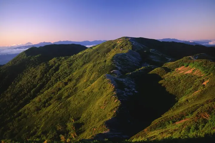
Mt. Chō (2,677 m) rises on the border of Matsumoto and Azumino in Nagano, on the southern Jōnen Range of the North Alps within Chūbu-Sangaku National Park. Its name comes from a butterfly-shaped snow patch that appears on the eastern flank in early spring. The broad summit ridge is one of the finest viewpoints in the North Alps, with the entire Yari–Hotaka skyline rising in full view across the Azusa River. The peak is reached from Mitsumata, Yokoo, or Tokusawa, and the Chōgatake-hütte on the summit ridge serves as a base for the popular ridge traverse to Mt. Jōnen. It is counted among Japan's 100 High Mountains, the 100 Famous Mountains of Shinshū, and the 2,500-Metre Peaks of Japan.
Mt. Chō at a glance
- Weather: The most settled day in the next 7 days is Wed, November 4: clear, gusts up to 7 m/s. Sat, Nov 7: strong wind (gusts up to 17 m/s).
- Route: The shortest is Mount Chogatake Return from Kamikochi via Tokusawa: about 11 h 41 min, 23.5 km, about 1,320 m of climbing.
Mt. Chō weather (hourly, 14 days)
Sunrise today 06:13, sunset 16:52
| Tue, 11/3 | Wed, 11/4 | Thu, 11/5 | Fri, 11/6 | Sat, 11/7 | Sun, 11/8 | Mon, 11/9 | Tue, 11/10 | Wed, 11/11 | Thu, 11/12 | Fri, 11/13 | Sat, 11/14 | Sun, 11/15 | Mon, 11/16 | Tue, 11/17 | |||||||||||||||||||||||||||||||||||||||||||||||||||||||||||||||||||||||
|---|---|---|---|---|---|---|---|---|---|---|---|---|---|---|---|---|---|---|---|---|---|---|---|---|---|---|---|---|---|---|---|---|---|---|---|---|---|---|---|---|---|---|---|---|---|---|---|---|---|---|---|---|---|---|---|---|---|---|---|---|---|---|---|---|---|---|---|---|---|---|---|---|---|---|---|---|---|---|---|---|---|---|---|---|---|
| Japan time | 15 | 17 | 19 | 21 | 23 | 1 | 3 | 5 | 7 | 9 | 11 | 13 | 15 | 18 | 21 | 0 | 3 | 6 | 9 | 12 | 15 | 18 | 21 | 0 | 3 | 6 | 9 | 12 | 15 | 18 | 21 | 0 | 3 | 6 | 9 | 12 | 15 | 18 | 21 | 0 | 3 | 6 | 9 | 12 | 15 | 18 | 21 | 0 | 3 | 6 | 9 | 15 | 21 | 3 | 9 | 15 | 21 | 3 | 9 | 15 | 21 | 3 | 9 | 15 | 21 | 3 | 9 | 15 | 21 | 3 | 9 | 15 | 21 | 3 | 9 | 15 | 21 | 3 | 9 | 15 | 21 | 3 | 9 | 15 | |
  |   |   | | | | | | | |  | |   |   | |   | | |   | | | | | | | |   | | | | |   | | |   |   | | | | | |  | | | | | | | |   | | | | | | |   | | | | |  | | | | | |   | | | | | | | | | | | | |   | | | | ||
| Temperature | °C | 3° | -1° | -4° | -5° | -6° | -5° | -4° | -5° | -3° | 1° | 4° | 6° | 6° | 1° | 1° | 0° | 0° | 1° | 3° | 6° | 8° | 3° | 3° | 2° | 2° | 2° | 4° | 7° | 5° | 0° | -2° | -3° | -5° | -6° | -5° | -3° | -4° | -7° | -7° | -7° | -8° | -9° | -1° | 3° | 1° | -4° | -4° | -4° | -3° | -3° | 0° | 1° | -8° | -10° | 0° | 1° | -4° | -8° | -5° | -2° | -9° | -9° | -2° | 1° | -8° | -5° | -2° | -1° | -7° | -7° | 0° | 4° | -6° | -6° | 3° | 3° | 1° | 1° | 4° | 4° | -3° | -6° | -3° | 1° |
| Precipitation | mm | 2.6 | 9 | 7 | 5 | 0.8 | 0.9 | 1.2 | 0.1 | 0.1 | 0.3 | 0.4 | 0.4 | 0.2 | 0.1 | 0.1 | 1.5 | 3.2 | 1.3 | 0.1 | 0.2 | 0.3 | 0.1 | 0.4 | 8 | 10 | 0.9 | 0.2 | 0.4 | 0.3 | |||||||||||||||||||||||||||||||||||||||||||||||||||||||
| New snow | cm | <.1 | 0.3 | 0.4 | 0.4 | 0.1 | <.1 | <.1 | <.1 | <.1 | <.1 | <.1 | 0.2 | 2.6 | 1.3 | <.1 | <.1 | <.1 | <.1 | ||||||||||||||||||||||||||||||||||||||||||||||||||||||||||||||||||
| Snow depth | cm | 0 | 0 | 0 | 0 | 0 | 0 | 0 | 0 | 0 | 0 | 0 | 0 | 0 | 0 | 0 | 0 | 0 | 0 | 0 | 0 | 0 | 0 | 0 | 0 | 0 | 0 | 0 | 0 | 0 | 0 | 0 | 0 | <1 | <1 | <1 | <1 | <1 | <1 | <1 | <1 | <1 | <1 | <1 | <1 | <1 | <1 | <1 | <1 | <1 | <1 | <1 | <1 | <1 | <1 | <1 | <1 | <1 | 2 | 2 | 2 | 2 | 2 | 2 | 1 | 1 | 1 | 1 | <1 | <1 | <1 | <1 | <1 | <1 | <1 | <1 | <1 | <1 | <1 | <1 | 0 | 0 | 0 | 0 | 0 |
| Wind | m/s | 1 | 1 | 2 | 2 | 2 | 1 | 1 | 1 | 1 | 1 | 2 | 2 | 1 | 0 | 1 | 0 | 1 | 0 | 1 | 1 | 1 | 1 | 2 | 2 | 2 | 1 | 2 | 3 | 3 | 3 | 3 | 3 | 3 | 3 | 3 | 4 | 3 | 3 | 3 | 3 | 2 | 1 | 0 | 0 | 1 | 1 | 1 | 2 | 2 | 2 | 2 | 1 | 2 | 2 | 1 | 4 | 2 | 6 | 1 | 0 | 0 | 1 | 0 | 1 | 1 | 2 | 0 | 1 | 0 | 1 | 1 | 0 | 2 | 3 | 1 | 1 | 2 | 2 | 1 | 2 | 0 | 0 | 1 | 1 |
| Wind gusts | m/s | 5 | 5 | 7 | 7 | 7 | 7 | 6 | 5 | 4 | 4 | 6 | 7 | 7 | 6 | 5 | 4 | 5 | 5 | 7 | 8 | 7 | 7 | 8 | 9 | 9 | 8 | 11 | 14 | 14 | 14 | 14 | 15 | 16 | 16 | 15 | 17 | 17 | 14 | 13 | 12 | 11 | 9 | 8 | 5 | 5 | 6 | 6 | 8 | 10 | 10 | 9 | 11 | 6 | 8 | 8 | 14 | 13 | 23 | 23 | 9 | 5 | 5 | 6 | 8 | 6 | 10 | 9 | 6 | 6 | 4 | 5 | 5 | 7 | 10 | 10 | 13 | 11 | 14 | 12 | 12 | 9 | 4 | 4 | 6 |
| Wind dir. | ↓ | ↓ | ↓ | ↓ | ↓ | ↓ | ↓ | ↓ | ↓ | ↓ | ↓ | ↓ | ↓ | ↓ | ↓ | ↓ | ↓ | ↓ | ↓ | ↓ | ↓ | ↓ | ↓ | ↓ | ↓ | ↓ | ↓ | ↓ | ↓ | ↓ | ↓ | ↓ | ↓ | ↓ | ↓ | ↓ | ↓ | ↓ | ↓ | ↓ | ↓ | ↓ | ↓ | ↓ | ↓ | ↓ | ↓ | ↓ | ↓ | ↓ | ↓ | ↓ | ↓ | ↓ | ↓ | ↓ | ↓ | ↓ | ↓ | ↓ | ↓ | ↓ | ↓ | ↓ | ↓ | ↓ | ↓ | ↓ | ↓ | ↓ | ↓ | ↓ | ↓ | ↓ | ↓ | ↓ | ↓ | ↓ | ↓ | ↓ | ↓ | ↓ | ↓ | ↓ | |
Mt. Chō hiking routes
- Mount Chogatake Return from Kamikochi via Tokusawa 23.5 km · Ascent 1,321 m Kamikochi (Bus stop)
- Mitsumata Circuit: Mount Mae-Jonen, Mount Jonen, Mount Cho-yari, and Mount Cho 19.7 km · Ascent 2,437 m parking
Hiking times are estimates calculated from the terrain.
Huts, campsites and lodging near Mt. Chō
Mountain huts
- Chogatake Hut 2026: open April 25–November 3 · reservation required · sleeps 150
- 大滝小屋
- 大滝山荘 2026: open July 20–August 31 · reservation required · sleeps 20
- Yokoosanso 2026: open April 27–November 3 · reservation required · sleeps 150
- 横尾避難小屋 unstaffed
Campsites
- 蝶ヶ岳ヒュッテ テントサイト
- Yokoo Campground
- Tokusawa Camping Ground
Lists that include Mt. Chō
Japan's 100 Highest Mountains · Koshinetsu 100 Famous Mountains · Tokai 100 Mountains · Shinshu 100 Famous Mountains · Shinshu Mountain Cards · Elevations of 1003 Mountains of Japan · 1000 Mountains of Japan
Mt. Chō facts
- Also known as
- 長塀ノ頭
- Elevation
- 2,677 m
- Location
- Matsumoto, Nagano
36.287426, 137.726063 - National Park
- 中部山岳国立公園
- Website
- chougatake.com
- Access Information
- www.city.azumino.nagano.jp
- Wikipedia
- ja.wikipedia.org