
Mount Yari
槍ヶ岳
Ōmachi-shi, Nagano / Matsumoto, Nagano · Elevation 3,180 m
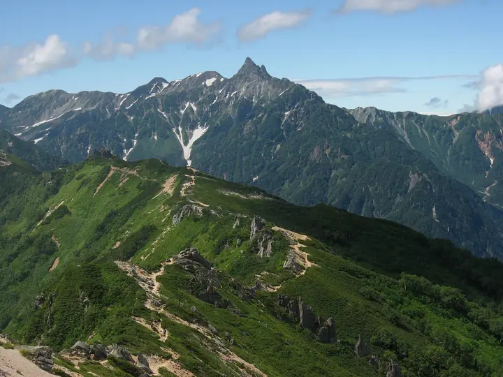
Mount Yari is a 3,180 m peak on the boundary between Matsumoto and Ōmachi in Nagano and Takayama in Gifu, the fifth-highest summit in Japan and the principal peak of the Hida Mountains. Within Chūbu-Sangaku National Park, it is listed in Fukada Kyūya's Hyakumeizan, the Hana-no-Hyakumeizan, and the Hyakkōzan. Its sharply pointed spire has long earned it the nickname "the Matterhorn of Japan," and it was first opened to pilgrims by the priest Banryū in the early 19th century. From the Yarigatake-Sansō hut just below the summit, the standard routes are the Yarisawa route from Kamikōchi via Yokoo, the Omote-Ginza traverse from Nakabusa Onsen along the Higashi-Kamao ridge, the Hidasawa route from Shinhotaka Onsen, and the Nishi-Ginza Diamond Course along the Nishi-Kamao ridge from Sugoroku Hut. As the icon of the Northern Alps, it draws the largest number of climbers of any major peak.
Mount Yari at a glance
- Weather: The most settled day in the next 7 days is Wed, November 4: clear, gusts up to 9 m/s. Thu, Nov 5, Fri, Nov 6, Sat, Nov 7: strong wind (gusts up to 20 m/s).
- Route: The shortest is Mount Yari Return via Yaridaira and Hida Valley from Shinhotaka: about 14 h 25 min, 28.0 km, about 2,170 m of climbing.
Mount Yari weather (hourly, 14 days)
Sunrise today 06:14, sunset 16:52
| Tue, 11/3 | Wed, 11/4 | Thu, 11/5 | Fri, 11/6 | Sat, 11/7 | Sun, 11/8 | Mon, 11/9 | Tue, 11/10 | Wed, 11/11 | Thu, 11/12 | Fri, 11/13 | Sat, 11/14 | Sun, 11/15 | Mon, 11/16 | Tue, 11/17 | |||||||||||||||||||||||||||||||||||||||||||||||||||||||||||||||||||||||
|---|---|---|---|---|---|---|---|---|---|---|---|---|---|---|---|---|---|---|---|---|---|---|---|---|---|---|---|---|---|---|---|---|---|---|---|---|---|---|---|---|---|---|---|---|---|---|---|---|---|---|---|---|---|---|---|---|---|---|---|---|---|---|---|---|---|---|---|---|---|---|---|---|---|---|---|---|---|---|---|---|---|---|---|---|---|
| Japan time | 15 | 17 | 19 | 21 | 23 | 1 | 3 | 5 | 7 | 9 | 11 | 13 | 15 | 18 | 21 | 0 | 3 | 6 | 9 | 12 | 15 | 18 | 21 | 0 | 3 | 6 | 9 | 12 | 15 | 18 | 21 | 0 | 3 | 6 | 9 | 12 | 15 | 18 | 21 | 0 | 3 | 6 | 9 | 12 | 15 | 18 | 21 | 0 | 3 | 6 | 9 | 15 | 21 | 3 | 9 | 15 | 21 | 3 | 9 | 15 | 21 | 3 | 9 | 15 | 21 | 3 | 9 | 15 | 21 | 3 | 9 | 15 | 21 | 3 | 9 | 15 | 21 | 3 | 9 | 15 | 21 | 3 | 9 | 15 | |
  |   |  | | | | | | | |  | |   |   |   | | | |   | | |   | | |   | | |   | | |   | | | |   | | | | | |  | | | | | |   | | | | | | | | | | | | |   | |  | | | | |   |   | | | | | | | |   | | | | | | | | | ||
| Temperature | °C | -3° | -7° | -10° | -10° | -9° | -8° | -7° | -7° | -5° | -1° | 1° | 2° | 1° | -3° | -2° | -2° | -2° | -1° | -1° | 2° | 3° | -1° | -1° | -2° | -2° | -2° | -2° | -1° | -3° | -6° | -8° | -9° | -11° | -12° | -12° | -11° | -12° | -14° | -16° | -15° | -15° | -13° | -6° | -3° | -5° | -10° | -8° | -8° | -8° | -9° | -7° | -6° | -14° | -14° | -7° | -7° | -9° | -15° | -11° | -10° | -13° | -13° | -6° | -6° | -13° | -9° | -8° | -7° | -12° | -10° | -3° | -3° | -9° | -9° | -2° | -3° | -3° | -3° | -2° | -5° | -10° | -8° | -5° | -4° |
| Precipitation | mm | 0.1 | 2.4 | 10 | 9 | 6 | 0.7 | 0.3 | 2.6 | 3.3 | 0.8 | 0.7 | 0.5 | 0.2 | 1.3 | 1.6 | 1.8 | 1.7 | 0.8 | 0.2 | 0.1 | 0.9 | 1.1 | 0.2 | 0.7 | 3.0 | 6 | 3.6 | 0.3 | 0.9 | 1.5 | 1.1 | 10 | 10 | 3.4 | 1.4 | 0.7 | ||||||||||||||||||||||||||||||||||||||||||||||||
| New snow | cm | 0.1 | 0.2 | 0.1 | 0.1 | 1.2 | 1.6 | 1.8 | 1.6 | 0.8 | 0.2 | <.1 | <.1 | <.1 | 0.1 | 0.8 | 0.9 | 0.1 | 0.7 | <.1 | 2.9 | 6.0 | 3.6 | 0.3 | 0.8 | 1.0 | <.1 | <.1 | 0.3 | 0.4 | 0.6 | ||||||||||||||||||||||||||||||||||||||||||||||||||||||
| Snow depth | cm | 0 | 0 | 0 | 0 | 0 | 0 | 0 | 0 | 0 | 0 | 0 | 0 | 0 | 0 | 0 | 0 | 0 | 0 | 0 | 0 | 0 | 0 | 0 | 0 | 0 | 0 | 0 | 0 | 0 | 0 | 0 | 1 | 2 | 4 | 5 | 5 | 5 | 5 | 5 | 5 | 5 | 5 | 4 | 4 | 4 | 4 | 4 | 4 | 4 | 5 | 6 | 5 | 5 | 5 | 5 | 5 | 7 | 12 | 14 | 14 | 13 | 13 | 12 | 12 | 11 | 12 | 13 | 12 | 12 | 12 | 12 | 11 | 11 | 11 | 10 | 8 | 7 | 6 | 4 | 4 | 4 | 4 | 4 | 4 |
| Wind | m/s | 2 | 1 | 1 | 1 | 1 | 1 | 1 | 0 | 1 | 2 | 2 | 2 | 2 | 1 | 1 | 1 | 1 | 1 | 3 | 3 | 3 | 1 | 2 | 2 | 3 | 3 | 3 | 4 | 4 | 4 | 4 | 4 | 4 | 4 | 4 | 5 | 3 | 3 | 3 | 3 | 2 | 2 | 1 | 1 | 1 | 1 | 1 | 2 | 3 | 2 | 2 | 1 | 1 | 1 | 2 | 4 | 3 | 7 | 3 | 2 | 1 | 1 | 2 | 1 | 1 | 3 | 2 | 1 | 1 | 1 | 1 | 1 | 1 | 2 | 2 | 1 | 4 | 3 | 2 | 3 | 1 | 0 | 1 | 2 |
| Wind gusts | m/s | 10 | 9 | 8 | 8 | 8 | 7 | 6 | 6 | 6 | 7 | 9 | 9 | 9 | 9 | 9 | 9 | 8 | 8 | 13 | 15 | 14 | 12 | 10 | 11 | 12 | 13 | 15 | 17 | 17 | 16 | 16 | 17 | 18 | 19 | 19 | 20 | 19 | 16 | 16 | 15 | 14 | 14 | 11 | 9 | 9 | 9 | 10 | 12 | 14 | 14 | 12 | 12 | 8 | 6 | 8 | 15 | 14 | 27 | 29 | 18 | 10 | 7 | 9 | 10 | 8 | 13 | 13 | 12 | 10 | 9 | 7 | 7 | 7 | 8 | 10 | 13 | 17 | 17 | 15 | 16 | 14 | 8 | 5 | 8 |
| Wind dir. | ↓ | ↓ | ↓ | ↓ | ↓ | ↓ | ↓ | ↓ | ↓ | ↓ | ↓ | ↓ | ↓ | ↓ | ↓ | ↓ | ↓ | ↓ | ↓ | ↓ | ↓ | ↓ | ↓ | ↓ | ↓ | ↓ | ↓ | ↓ | ↓ | ↓ | ↓ | ↓ | ↓ | ↓ | ↓ | ↓ | ↓ | ↓ | ↓ | ↓ | ↓ | ↓ | ↓ | ↓ | ↓ | ↓ | ↓ | ↓ | ↓ | ↓ | ↓ | ↓ | ↓ | ↓ | ↓ | ↓ | ↓ | ↓ | ↓ | ↓ | ↓ | ↓ | ↓ | ↓ | ↓ | ↓ | ↓ | ↓ | ↓ | ↓ | ↓ | ↓ | ↓ | ↓ | ↓ | ↓ | ↓ | ↓ | ↓ | ↓ | ↓ | ↓ | ↓ | ↓ | |
Mount Yari hiking routes
- Mount Yari Return via Yaridaira and Hida Valley from Shinhotaka 28.0 km · Ascent 2,165 m Shinhotaka Onsen Bus Stop (Bus stop), Shinhotaka Ropeway Bus Stop (Bus stop), 深山荘 登山者用駐車場
- Mount Minami Circuit from Shinhotaka Onsen via Yaridaira and Senjonokoshi 30.4 km · Ascent 2,453 m Shinhotaka Onsen Bus Stop (Bus stop), Shinhotaka Ropeway Bus Stop (Bus stop), 深山荘 登山者用駐車場
- Mount Yari Return from Kamikochi via Yarisawa 39.8 km · Ascent 1,955 m Kamikochi (Bus stop)
Hiking times are estimates calculated from the terrain.
Huts, campsites and lodging near Mount Yari
Mountain huts
- Yarigatake Sanso 2026: open April 27–November 3 · reservation required · sleeps 300
- Sessho Hutte 2026: open June 6–October 11 · reservation required · sleeps 80
- Hutte Oyari 2026: open July 1–October 12 · reservation required · sleeps 96
- 播隆窟
- Yaridaira Goya 2026: open July 10–October 12 · reservation required · sleeps 80
Campsites
- 殺生ヒュッテテント場
- 槍平小屋テン場
- 南岳小屋テント場
- Babadaira Camp Site
- 北穂高岳南陵テント場
Lists that include Mount Yari
100 Famous Japanese Mountains · Japan 200 Famous Mountains · Japan's 300 Famous Mountains · 100 Famous Mountains of Flowers · Japan's 100 Highest Mountains · New Japan 100 Famous Mountains · Japan's 3000 m Peaks · Illustrated Collection of Japan's Famous Mountains · 100 Famous Hot Spring Mountains · Koshinetsu 100 Famous Mountains · Tokai 100 Mountains · Shinshu 100 Famous Mountains · 100 Mountains of Gifu · Shinshu Mountain Cards · Elevations of 1003 Mountains of Japan · 1000 Mountains of Japan
Mount Yari facts
- Elevation
- 3,180 m
- Location
- Ōmachi-shi, Nagano / Matsumoto, Nagano
36.341981, 137.647630 - National Park
- 中部山岳国立公園
- Website
- www.yarigatake.co.jp
- Trail Map
- www.yarigatake.co.jp
- Access Information
- www.yarigatake.co.jp
- Wikipedia
- ja.wikipedia.org