
Mount Yakushi
薬師岳
Toyama, Toyama · Elevation 2,926 m
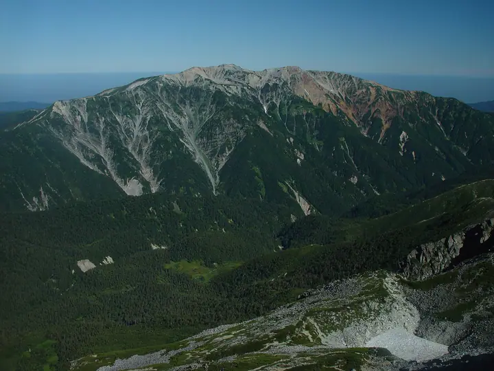
Mount Yakushi is a 2,926 m peak in Toyama City, Toyama Prefecture, rising on the central main ridge of the Hida Mountains (Northern Alps). Within Chūbu-Sangaku National Park, it is listed in Fukada Kyūya's Hyakumeizan and the Hana-no-Hyakumeizan. Despite its gentle silhouette, the eastern flank holds an outstanding suite of glacial cirques — Kinsakudani, Central, and Nanryō — designated together as part of the national Special Natural Monument "Kurobe River Headwaters Cirque Group." The summit has long been venerated as the seat of the Buddha Bhaisajyaguru (Yakushi Nyorai), whose image is enshrined in a small hokora just below the top. The standard route climbs from the Oritate trailhead by Lake Arimine via Tarōdaira and Yakushi-tōge; the Arimine Forest Road that serves it is open from early June to mid-November.
Mount Yakushi at a glance
- Weather: The most settled day in the next 7 days is Sun, November 8: clear, gusts up to 9 m/s. Thu, Nov 5, Sat, Nov 7: strong wind (gusts up to 17 m/s).
- Route: The shortest is Mount Yakushi Return from Oritate via Tarōdaira: about 12 h 48 min, 20.8 km, about 1,790 m of climbing.
Mount Yakushi weather (hourly, 14 days)
Sunrise today 06:14, sunset 16:53
| Tue, 11/3 | Wed, 11/4 | Thu, 11/5 | Fri, 11/6 | Sat, 11/7 | Sun, 11/8 | Mon, 11/9 | Tue, 11/10 | Wed, 11/11 | Thu, 11/12 | Fri, 11/13 | Sat, 11/14 | Sun, 11/15 | Mon, 11/16 | Tue, 11/17 | |||||||||||||||||||||||||||||||||||||||||||||||||||||||||||||||||||||||
|---|---|---|---|---|---|---|---|---|---|---|---|---|---|---|---|---|---|---|---|---|---|---|---|---|---|---|---|---|---|---|---|---|---|---|---|---|---|---|---|---|---|---|---|---|---|---|---|---|---|---|---|---|---|---|---|---|---|---|---|---|---|---|---|---|---|---|---|---|---|---|---|---|---|---|---|---|---|---|---|---|---|---|---|---|---|
| Japan time | 15 | 17 | 19 | 21 | 23 | 1 | 3 | 5 | 7 | 9 | 11 | 13 | 15 | 18 | 21 | 0 | 3 | 6 | 9 | 12 | 15 | 18 | 21 | 0 | 3 | 6 | 9 | 12 | 15 | 18 | 21 | 0 | 3 | 6 | 9 | 12 | 15 | 18 | 21 | 0 | 3 | 6 | 9 | 12 | 15 | 18 | 21 | 0 | 3 | 6 | 9 | 15 | 21 | 3 | 9 | 15 | 21 | 3 | 9 | 15 | 21 | 3 | 9 | 15 | 21 | 3 | 9 | 15 | 21 | 3 | 9 | 15 | 21 | 3 | 9 | 15 | 21 | 3 | 9 | 15 | 21 | 3 | 9 | 15 | |
  |  |   | | | | | | | |  | |   |   | |   | | |   | | | | | | | | |   | |   | |   | | |   | | | | |   | |  | | | | |   | | | | |   | | | | | | | | |   |  | | | | |   |   | | | | | | | | | | | | |   | | | | ||
| Temperature | °C | -1° | -6° | -8° | -7° | -7° | -7° | -6° | -6° | -5° | 1° | 3° | 4° | 3° | -2° | 0° | 0° | 0° | 1° | 1° | 3° | 4° | 1° | 1° | 1° | 0° | 0° | -1° | -1° | -2° | -4° | -6° | -7° | -9° | -9° | -9° | -9° | -9° | -11° | -12° | -13° | -14° | -11° | -4° | -3° | -4° | -7° | -7° | -6° | -6° | -6° | -5° | -5° | -12° | -12° | -4° | -5° | -7° | -13° | -10° | -9° | -11° | -12° | -4° | -5° | -11° | -7° | -8° | -7° | -11° | -11° | -1° | -1° | -9° | -7° | -1° | -2° | -1° | -1° | -1° | -5° | -10° | -9° | -4° | -3° |
| Precipitation | mm | 1.8 | 9 | 8 | 6 | 1.0 | 0.7 | 1.9 | 2.8 | 1.5 | 1.5 | 0.7 | 1.5 | 0.8 | 3.3 | 2.9 | 2.7 | 2.8 | 1.3 | 0.5 | 0.1 | 0.1 | 0.3 | 1.2 | 1.4 | 0.1 | 1.2 | 3.6 | 9 | 6 | 1.5 | 2.1 | 4.9 | 0.3 | 0.9 | 9 | 8 | 6 | 6 | 3.1 | |||||||||||||||||||||||||||||||||||||||||||||
| New snow | cm | 0.3 | 0.4 | 2.7 | 2.8 | 2.7 | 2.8 | 1.3 | 0.5 | 0.1 | <.1 | 0.1 | 0.3 | 1.2 | 1.1 | <.1 | 1.1 | <.1 | 3.2 | 8.6 | 6.1 | 1.5 | <.1 | 2.0 | 3.9 | 0.3 | 0.1 | 1.5 | 2.0 | ||||||||||||||||||||||||||||||||||||||||||||||||||||||||
| Snow depth | cm | 0 | 0 | 0 | 0 | 0 | 0 | 0 | 0 | 0 | 0 | 0 | 0 | 0 | 0 | 0 | 0 | 0 | 0 | 0 | 0 | 0 | 0 | 0 | 0 | 0 | 0 | 0 | 0 | 0 | 0 | <1 | 2 | 5 | 7 | 9 | 10 | 10 | 10 | 10 | 10 | 9 | 9 | 9 | 9 | 8 | 8 | 8 | 8 | 9 | 9 | 9 | 9 | 8 | 8 | 8 | 8 | 10 | 17 | 22 | 22 | 21 | 21 | 20 | 19 | 19 | 20 | 23 | 23 | 22 | 22 | 21 | 20 | 20 | 20 | 19 | 17 | 15 | 13 | 11 | 11 | 12 | 12 | 12 | 12 |
| Wind | m/s | 1 | 0 | 1 | 1 | 1 | 1 | 1 | 1 | 1 | 2 | 3 | 3 | 3 | 2 | 3 | 0 | 1 | 1 | 2 | 4 | 3 | 1 | 3 | 3 | 2 | 3 | 3 | 4 | 4 | 4 | 4 | 4 | 4 | 4 | 4 | 4 | 3 | 2 | 0 | 1 | 1 | 1 | 1 | 2 | 0 | 2 | 2 | 2 | 3 | 3 | 2 | 0 | 1 | 1 | 3 | 4 | 3 | 7 | 4 | 3 | 1 | 0 | 1 | 1 | 1 | 2 | 3 | 2 | 1 | 0 | 1 | 1 | 2 | 2 | 3 | 3 | 6 | 3 | 2 | 3 | 1 | 0 | 1 | 2 |
| Wind gusts | m/s | 9 | 7 | 6 | 5 | 5 | 5 | 5 | 5 | 6 | 8 | 10 | 11 | 11 | 11 | 12 | 12 | 7 | 9 | 14 | 17 | 16 | 11 | 11 | 12 | 12 | 11 | 12 | 13 | 15 | 14 | 15 | 14 | 15 | 16 | 16 | 17 | 17 | 14 | 11 | 10 | 9 | 9 | 9 | 9 | 8 | 8 | 10 | 11 | 13 | 13 | 11 | 11 | 6 | 6 | 11 | 16 | 15 | 24 | 25 | 17 | 13 | 7 | 8 | 11 | 6 | 9 | 12 | 11 | 11 | 10 | 6 | 8 | 7 | 10 | 13 | 17 | 22 | 22 | 14 | 13 | 13 | 7 | 5 | 8 |
| Wind dir. | ↓ | ↓ | ↓ | ↓ | ↓ | ↓ | ↓ | ↓ | ↓ | ↓ | ↓ | ↓ | ↓ | ↓ | ↓ | ↓ | ↓ | ↓ | ↓ | ↓ | ↓ | ↓ | ↓ | ↓ | ↓ | ↓ | ↓ | ↓ | ↓ | ↓ | ↓ | ↓ | ↓ | ↓ | ↓ | ↓ | ↓ | ↓ | ↓ | ↓ | ↓ | ↓ | ↓ | ↓ | ↓ | ↓ | ↓ | ↓ | ↓ | ↓ | ↓ | ↓ | ↓ | ↓ | ↓ | ↓ | ↓ | ↓ | ↓ | ↓ | ↓ | ↓ | ↓ | ↓ | ↓ | ↓ | ↓ | ↓ | ↓ | ↓ | ↓ | ↓ | ↓ | ↓ | ↓ | ↓ | ↓ | ↓ | ↓ | ↓ | ↓ | ↓ | ↓ | ↓ | |
Mount Yakushi hiking routes
Hiking times are estimates calculated from the terrain.
Huts, campsites and lodging near Mount Yakushi
Mountain huts
- Yakushidake Sanso 2026: open July 1–October 4 · reservation required · sleeps 80
- Tarodairakoya 2026: open June 6–October 18 · reservation required · sleeps 150
- Sugonokkoshikoya 2026: open July 10–September 25 · reservation required · sleeps 35
- 薬師沢小屋 2026: open July 1–October 8 · reservation required · sleeps 50
- 高天原山荘 2026: open July 5–September 30 · reservation required · sleeps 45
Campsites
- Tarodaira Campground
- Sugonokkoshi Campground
Lists that include Mount Yakushi
100 Famous Japanese Mountains · Japan 200 Famous Mountains · Japan's 300 Famous Mountains · 100 Famous Mountains of Flowers · Japan's 100 Highest Mountains · 100 Mountains of Hokuriku · 100 Mountains of Toyama · Elevations of 1003 Mountains of Japan · 1000 Mountains of Japan
Mount Yakushi facts
- Elevation
- 2,926 m
- Location
- Toyama, Toyama
36.468863, 137.544805 - National Park
- 中部山岳国立公園
- Website
- www.info-toyama.com
- Trail Map
- www.pref.toyama.jp (PDF)
- Access Information
- www.arimine.net
- Wikipedia
- ja.wikipedia.org