
Mount Kurobegorō
黒部五郎岳
Takayama, Gifu / Hida, Gifu / Toyama, Toyama · Elevation 2,840 m
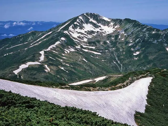
Mount Kurobegorō is a 2,840 m peak on the boundary between Toyama City in Toyama Prefecture and Takayama and Hida in Gifu Prefecture, set in the Kurobe River headwaters at the centre of the Hida Mountains. Within Chūbu-Sangaku National Park, it is listed in Fukada Kyūya's Hyakumeizan and the Hana-no-Hyakumeizan. Its defining feature is the large eastern cirque, the Kurobegorō Karu, whose floor is strewn with boulders and small ponds in a striking landscape. The ridgeline running south from Tarōdaira through Kita-no-Mata, Kurobegorō, Mitsumata-Renge, and Sugoroku to Mount Yari is known as the Nishi-Ginza Diamond Course and is favored as a relatively gentle traverse. The Kurobegorō-goya hut sits just below the cirque and operates from roughly mid-July to mid-October, defining the practical climbing season.
Mount Kurobegorō at a glance
- Weather: The most settled day in the next 7 days is Sun, November 8: clear, gusts up to 8 m/s. Fri, Nov 6, Sat, Nov 7: strong wind (gusts up to 16 m/s).
Mount Kurobegorō weather (hourly, 14 days)
Sunrise today 06:14, sunset 16:53
| Tue, 11/3 | Wed, 11/4 | Thu, 11/5 | Fri, 11/6 | Sat, 11/7 | Sun, 11/8 | Mon, 11/9 | Tue, 11/10 | Wed, 11/11 | Thu, 11/12 | Fri, 11/13 | Sat, 11/14 | Sun, 11/15 | Mon, 11/16 | Tue, 11/17 | |||||||||||||||||||||||||||||||||||||||||||||||||||||||||||||||||||||||
|---|---|---|---|---|---|---|---|---|---|---|---|---|---|---|---|---|---|---|---|---|---|---|---|---|---|---|---|---|---|---|---|---|---|---|---|---|---|---|---|---|---|---|---|---|---|---|---|---|---|---|---|---|---|---|---|---|---|---|---|---|---|---|---|---|---|---|---|---|---|---|---|---|---|---|---|---|---|---|---|---|---|---|---|---|---|
| Japan time | 21 | 23 | 1 | 3 | 5 | 7 | 9 | 11 | 13 | 15 | 17 | 19 | 21 | 0 | 3 | 6 | 9 | 12 | 15 | 18 | 21 | 0 | 3 | 6 | 9 | 12 | 15 | 18 | 21 | 0 | 3 | 6 | 9 | 12 | 15 | 18 | 21 | 0 | 3 | 6 | 9 | 12 | 15 | 18 | 21 | 0 | 3 | 6 | 9 | 12 | 15 | 21 | 3 | 9 | 15 | 21 | 3 | 9 | 15 | 21 | 3 | 9 | 15 | 21 | 3 | 9 | 15 | 21 | 3 | 9 | 15 | 21 | 3 | 9 | 15 | 21 | 3 | 9 | 15 | 21 | 3 | 9 | 15 | 21 | |
  | | |  | |   | | | | |   | | |   | | |   | | | |   | |   | |   |   | | | |   | | |   | | | |   | | | | | | | | | | | | |   | | | |  |   | | | | | |  | | | | |   |   | | | | | | | | | | | | |   | | | | | ||
| Temperature | °C | -7° | -6° | -5° | -5° | -5° | -3° | 2° | 4° | 4° | 3° | 0° | 0° | 1° | 1° | 1° | 2° | 3° | 6° | 4° | 2° | 2° | 1° | 0° | 0° | 0° | 1° | -1° | -4° | -5° | -6° | -7° | -9° | -8° | -8° | -9° | -10° | -11° | -12° | -11° | -11° | -3° | -1° | -2° | -7° | -5° | -4° | -3° | -3° | -2° | -1° | -3° | -9° | -10° | -3° | -4° | -6° | -12° | -9° | -8° | -11° | -10° | -4° | -4° | -10° | -7° | -7° | -5° | -10° | -8° | -1° | -1° | -7° | -6° | 0° | -1° | 0° | -1° | 0° | -3° | -8° | -6° | -3° | -2° | -5° |
| Precipitation | mm | 3.6 | 8 | 3.8 | 0.5 | 0.2 | 0.7 | 0.1 | 1.3 | 1.1 | 10 | 3.4 | 0.8 | 0.7 | 0.4 | 0.8 | 0.9 | 0.9 | 1.0 | 1.6 | 1.4 | 1.1 | 0.9 | 0.2 | 0.8 | 2.9 | 7 | 4.0 | 0.5 | 1.1 | 3.1 | 0.2 | 0.9 | 10 | 9 | 5.0 | 2.3 | 1.0 | |||||||||||||||||||||||||||||||||||||||||||||||
| New snow | cm | 0.1 | <.1 | <.1 | 0.7 | 0.8 | 0.9 | 1.5 | 1.3 | 1.1 | 0.9 | 0.1 | <.1 | <.1 | <.1 | 0.5 | <.1 | 2.5 | 6.4 | 4.0 | 0.5 | 0.9 | 2.3 | 0.1 | <.1 | <.1 | 0.2 | 0.8 | |||||||||||||||||||||||||||||||||||||||||||||||||||||||||
| Snow depth | cm | 0 | 0 | 0 | 0 | 0 | 0 | 0 | 0 | 0 | 0 | 0 | 0 | 0 | 0 | 0 | 0 | 0 | 0 | 0 | 0 | 0 | 0 | 0 | 0 | 0 | 0 | 0 | 0 | 0 | 1 | 2 | 3 | 5 | 5 | 5 | 5 | 5 | 5 | 5 | 5 | 5 | 4 | 4 | 4 | 4 | 4 | 5 | 5 | 5 | 5 | 5 | 5 | 5 | 4 | 4 | 6 | 11 | 14 | 14 | 13 | 13 | 13 | 12 | 12 | 12 | 14 | 13 | 13 | 13 | 13 | 12 | 11 | 11 | 11 | 9 | 8 | 5 | 4 | 3 | 3 | 3 | 3 | 3 | 3 |
| Wind | m/s | 1 | 1 | 1 | 1 | 1 | 1 | 2 | 3 | 3 | 3 | 1 | 2 | 2 | 1 | 0 | 1 | 2 | 3 | 2 | 2 | 2 | 2 | 3 | 4 | 4 | 5 | 5 | 4 | 5 | 4 | 4 | 5 | 4 | 5 | 4 | 3 | 2 | 2 | 2 | 1 | 1 | 1 | 1 | 1 | 1 | 2 | 3 | 3 | 2 | 3 | 2 | 1 | 1 | 2 | 4 | 2 | 7 | 4 | 3 | 2 | 0 | 2 | 1 | 1 | 2 | 3 | 2 | 1 | 1 | 1 | 1 | 1 | 1 | 2 | 1 | 4 | 2 | 3 | 4 | 2 | 0 | 1 | 2 | 1 |
| Wind gusts | m/s | 5 | 5 | 4 | 4 | 4 | 5 | 6 | 8 | 9 | 9 | 8 | 7 | 8 | 7 | 7 | 10 | 8 | 10 | 10 | 9 | 11 | 12 | 15 | 12 | 12 | 15 | 16 | 14 | 14 | 14 | 12 | 15 | 16 | 16 | 16 | 14 | 13 | 11 | 10 | 10 | 8 | 7 | 7 | 6 | 6 | 9 | 12 | 12 | 11 | 10 | 9 | 6 | 6 | 8 | 14 | 12 | 21 | 22 | 17 | 11 | 7 | 7 | 8 | 5 | 9 | 11 | 11 | 10 | 8 | 5 | 6 | 5 | 6 | 8 | 12 | 17 | 17 | 10 | 14 | 13 | 8 | 4 | 7 | 6 |
| Wind dir. | ↓ | ↓ | ↓ | ↓ | ↓ | ↓ | ↓ | ↓ | ↓ | ↓ | ↓ | ↓ | ↓ | ↓ | ↓ | ↓ | ↓ | ↓ | ↓ | ↓ | ↓ | ↓ | ↓ | ↓ | ↓ | ↓ | ↓ | ↓ | ↓ | ↓ | ↓ | ↓ | ↓ | ↓ | ↓ | ↓ | ↓ | ↓ | ↓ | ↓ | ↓ | ↓ | ↓ | ↓ | ↓ | ↓ | ↓ | ↓ | ↓ | ↓ | ↓ | ↓ | ↓ | ↓ | ↓ | ↓ | ↓ | ↓ | ↓ | ↓ | ↓ | ↓ | ↓ | ↓ | ↓ | ↓ | ↓ | ↓ | ↓ | ↓ | ↓ | ↓ | ↓ | ↓ | ↓ | ↓ | ↓ | ↓ | ↓ | ↓ | ↓ | ↓ | ↓ | ↓ | |
Huts, campsites and lodging near Mount Kurobegorō
Mountain huts
- Kurobegorogoya 2026: open July 10–October 15 · reservation required · sleeps 60
- 薬師沢小屋 2026: open July 1–October 8 · reservation required · sleeps 50
- 雲ノ平山荘 2026: open July 1–October 15 · reservation required · sleeps 60
Campsites
- 黒部五郎キャンプ場
- 雲ノ平キャンプ場
- 三俣蓮華岳テント場
Lists that include Mount Kurobegorō
100 Famous Japanese Mountains · Japan 200 Famous Mountains · Japan's 300 Famous Mountains · 100 Famous Mountains of Flowers · Japan's 100 Highest Mountains · Tokai 100 Mountains · 100 Mountains of Hokuriku · 100 Mountains of Toyama · 100 Mountains of Gifu · Elevations of 1003 Mountains of Japan · 1000 Mountains of Japan
Mount Kurobegorō facts
- Also known as
- 中ノ俣岳 · 鍋岳
- Elevation
- 2,840 m
- Location
- Takayama, Gifu / Hida, Gifu / Toyama, Toyama
36.392585, 137.539945 - National Park
- 中部山岳国立公園
- Website
- www.hida-kankou.jp
- Trail Map
- www.pref.toyama.jp (PDF)
- Access Information
- www.arimine.net
- Wikipedia
- ja.wikipedia.org