
Mt. Ōbami
大喰岳
Matsumoto, Nagano · Elevation 3,101 m
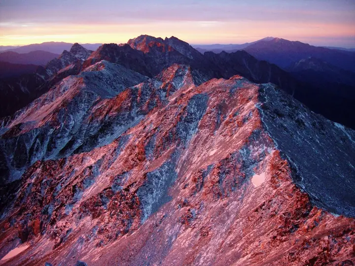
Mt. Ōbami is a 3,101 m peak — the 10th highest in Japan — on the main Yari–Hotaka ridge of the Hida Mountains (Northern Alps), straddling Matsumoto (Nagano) and Takayama (Gifu). Standing just south of Yarigatake and north of Naka-dake, its summit forms a twin plateau. The name ("big-eating mountain") came from hunters who watched herds of wild animals graze its alpine grasses. First climbed in August 1909 by a party including Usui Masao. Within a Special Protection Zone of Chūbu Sangaku National Park, it is the first 3,000 m peak met when traversing south from Yarigatake.
Mt. Ōbami at a glance
- Weather: The most settled day in the next 7 days is Wed, November 4: clear, gusts up to 9 m/s. Thu, Nov 5, Fri, Nov 6, Sat, Nov 7: strong wind (gusts up to 20 m/s).
- Route: The shortest is Mount Minami Circuit from Shinhotaka Onsen via Yaridaira and Senjonokoshi: about 16 h 8 min, 30.4 km, about 2,450 m of climbing.
Mt. Ōbami weather (hourly, 14 days)
Sunrise today 06:14, sunset 16:52
| Tue, 11/3 | Wed, 11/4 | Thu, 11/5 | Fri, 11/6 | Sat, 11/7 | Sun, 11/8 | Mon, 11/9 | Tue, 11/10 | Wed, 11/11 | Thu, 11/12 | Fri, 11/13 | Sat, 11/14 | Sun, 11/15 | Mon, 11/16 | Tue, 11/17 | |||||||||||||||||||||||||||||||||||||||||||||||||||||||||||||||||||||||
|---|---|---|---|---|---|---|---|---|---|---|---|---|---|---|---|---|---|---|---|---|---|---|---|---|---|---|---|---|---|---|---|---|---|---|---|---|---|---|---|---|---|---|---|---|---|---|---|---|---|---|---|---|---|---|---|---|---|---|---|---|---|---|---|---|---|---|---|---|---|---|---|---|---|---|---|---|---|---|---|---|---|---|---|---|---|
| Japan time | 15 | 17 | 19 | 21 | 23 | 1 | 3 | 5 | 7 | 9 | 11 | 13 | 15 | 18 | 21 | 0 | 3 | 6 | 9 | 12 | 15 | 18 | 21 | 0 | 3 | 6 | 9 | 12 | 15 | 18 | 21 | 0 | 3 | 6 | 9 | 12 | 15 | 18 | 21 | 0 | 3 | 6 | 9 | 12 | 15 | 18 | 21 | 0 | 3 | 6 | 9 | 15 | 21 | 3 | 9 | 15 | 21 | 3 | 9 | 15 | 21 | 3 | 9 | 15 | 21 | 3 | 9 | 15 | 21 | 3 | 9 | 15 | 21 | 3 | 9 | 15 | 21 | 3 | 9 | 15 | 21 | 3 | 9 | 15 | |
  |   |  | | | | | | | |  | |   |   |   | | | |   | | |   | | |   | | |   | | |   | | | |   | | | | | |  | | | | | |   | | | | | | | | | | | | |   | |  | | | | |   |   | | | | | | | |   | | | | | | | | | ||
| Temperature | °C | -2° | -7° | -9° | -9° | -9° | -8° | -6° | -6° | -5° | -1° | 1° | 2° | 1° | -3° | -2° | -2° | -2° | -1° | 0° | 2° | 4° | -1° | -1° | -1° | -1° | -2° | -2° | -1° | -2° | -6° | -8° | -9° | -11° | -11° | -11° | -11° | -11° | -14° | -15° | -14° | -14° | -13° | -5° | -3° | -5° | -9° | -8° | -8° | -8° | -8° | -6° | -6° | -13° | -14° | -6° | -6° | -9° | -14° | -11° | -9° | -13° | -12° | -5° | -5° | -13° | -8° | -8° | -6° | -11° | -9° | -2° | -2° | -9° | -9° | -2° | -3° | -3° | -3° | -2° | -4° | -9° | -8° | -4° | -4° |
| Precipitation | mm | 0.1 | 2.4 | 10 | 9 | 6 | 0.7 | 0.3 | 2.6 | 3.3 | 0.8 | 0.7 | 0.5 | 0.2 | 1.3 | 1.6 | 1.8 | 1.7 | 0.8 | 0.2 | 0.1 | 0.9 | 1.1 | 0.2 | 0.7 | 3.0 | 6 | 3.6 | 0.3 | 0.9 | 1.5 | 1.1 | 10 | 10 | 3.4 | 1.4 | 0.7 | ||||||||||||||||||||||||||||||||||||||||||||||||
| New snow | cm | 0.1 | 0.2 | 0.1 | 0.1 | 1.2 | 1.6 | 1.8 | 1.6 | 0.8 | 0.2 | <.1 | <.1 | <.1 | 0.1 | 0.8 | 0.9 | 0.1 | 0.7 | <.1 | 2.9 | 6.0 | 3.6 | 0.3 | 0.8 | 1.0 | <.1 | <.1 | 0.3 | 0.4 | 0.6 | ||||||||||||||||||||||||||||||||||||||||||||||||||||||
| Snow depth | cm | 0 | 0 | 0 | 0 | 0 | 0 | 0 | 0 | 0 | 0 | 0 | 0 | 0 | 0 | 0 | 0 | 0 | 0 | 0 | 0 | 0 | 0 | 0 | 0 | 0 | 0 | 0 | 0 | 0 | 0 | 0 | 1 | 2 | 4 | 5 | 5 | 5 | 5 | 5 | 5 | 5 | 5 | 4 | 4 | 4 | 4 | 4 | 4 | 4 | 5 | 6 | 5 | 5 | 5 | 5 | 5 | 7 | 12 | 14 | 14 | 13 | 13 | 12 | 12 | 11 | 12 | 13 | 12 | 12 | 12 | 12 | 11 | 11 | 11 | 10 | 8 | 7 | 6 | 4 | 4 | 4 | 4 | 4 | 4 |
| Wind | m/s | 2 | 1 | 1 | 1 | 1 | 1 | 1 | 0 | 1 | 2 | 2 | 2 | 2 | 1 | 1 | 1 | 1 | 1 | 3 | 3 | 3 | 1 | 2 | 2 | 3 | 3 | 3 | 4 | 4 | 4 | 4 | 4 | 4 | 4 | 4 | 5 | 3 | 3 | 3 | 3 | 2 | 2 | 1 | 1 | 1 | 1 | 1 | 2 | 3 | 2 | 2 | 1 | 1 | 1 | 2 | 4 | 3 | 7 | 3 | 2 | 1 | 1 | 2 | 1 | 1 | 3 | 2 | 1 | 1 | 1 | 1 | 1 | 1 | 2 | 2 | 1 | 4 | 3 | 2 | 3 | 1 | 0 | 1 | 2 |
| Wind gusts | m/s | 10 | 9 | 8 | 8 | 8 | 7 | 6 | 6 | 6 | 7 | 9 | 9 | 9 | 9 | 9 | 9 | 8 | 8 | 13 | 15 | 14 | 12 | 10 | 11 | 12 | 13 | 15 | 17 | 17 | 16 | 16 | 17 | 18 | 19 | 19 | 20 | 19 | 16 | 16 | 15 | 14 | 14 | 11 | 9 | 9 | 9 | 10 | 12 | 14 | 14 | 12 | 12 | 8 | 6 | 8 | 15 | 14 | 27 | 29 | 18 | 10 | 7 | 9 | 10 | 8 | 13 | 13 | 12 | 10 | 9 | 7 | 7 | 7 | 8 | 10 | 13 | 17 | 17 | 15 | 16 | 14 | 8 | 5 | 8 |
| Wind dir. | ↓ | ↓ | ↓ | ↓ | ↓ | ↓ | ↓ | ↓ | ↓ | ↓ | ↓ | ↓ | ↓ | ↓ | ↓ | ↓ | ↓ | ↓ | ↓ | ↓ | ↓ | ↓ | ↓ | ↓ | ↓ | ↓ | ↓ | ↓ | ↓ | ↓ | ↓ | ↓ | ↓ | ↓ | ↓ | ↓ | ↓ | ↓ | ↓ | ↓ | ↓ | ↓ | ↓ | ↓ | ↓ | ↓ | ↓ | ↓ | ↓ | ↓ | ↓ | ↓ | ↓ | ↓ | ↓ | ↓ | ↓ | ↓ | ↓ | ↓ | ↓ | ↓ | ↓ | ↓ | ↓ | ↓ | ↓ | ↓ | ↓ | ↓ | ↓ | ↓ | ↓ | ↓ | ↓ | ↓ | ↓ | ↓ | ↓ | ↓ | ↓ | ↓ | ↓ | ↓ | |
Mt. Ōbami hiking routes
Hiking times are estimates calculated from the terrain.
Huts, campsites and lodging near Mt. Ōbami
Mountain huts
- Sessho Hutte 2026: open June 6–October 11 · reservation required · sleeps 80
- Yarigatake Sanso 2026: open April 27–November 3 · reservation required · sleeps 300
- 播隆窟
- Hutte Oyari 2026: open July 1–October 12 · reservation required · sleeps 96
- Yaridaira Goya 2026: open July 10–October 12 · reservation required · sleeps 80
Campsites
- 殺生ヒュッテテント場
- 槍平小屋テン場
- 南岳小屋テント場
- Babadaira Camp Site
- 北穂高岳南陵テント場
Lists that include Mt. Ōbami
Japan's 100 Highest Mountains · Japan's 3000 m Peaks · Elevations of 1003 Mountains of Japan
Mt. Ōbami facts
- Elevation
- 3,101 m
- Location
- Matsumoto, Nagano
36.335810, 137.646058 - National Park
- 中部山岳国立公園
- Trail Map
- www.yarigatake.co.jp
- Access Information
- www.yarigatake.co.jp
- Wikipedia
- ja.wikipedia.org