
Kita-no-Matadake
北ノ俣岳
Toyama, Toyama · Elevation 2,662 m
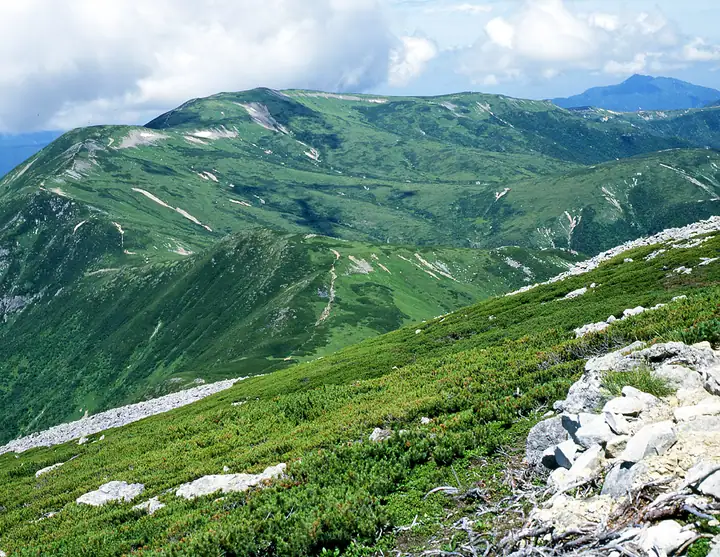
Kita-no-Mata-dake is a 2,662 m peak on the border between Toyama City in Toyama and Hida City in Gifu, set south of Mount Yakushi in the headwaters of the Kurobe River in the Hida range. The area is designated a Special Protection Zone of Chūbu-Sangaku National Park, and the gentle bamboo-grass ridges and alpine wildflower meadows make the traverse a celebrated walk; the peak also goes by the local name Kami-no-take. The standard approach leaves Oritate trailhead, passes Tarōbei-daira and the Tarōdaira Hut, and reaches the summit on the way to Kurobe-Gorōdake, Yakushi, or Kumonotaira. The peak features in Shin Hana no Hyakumeizan, Toyama no Hyakuzan, and Gifu Hyakushūzan.
Kita-no-Matadake at a glance
- Weather: The most settled day in the next 7 days is Sun, November 8: clear, gusts up to 9 m/s. Thu, Nov 5, Sat, Nov 7: strong wind (gusts up to 17 m/s).
Kita-no-Matadake weather (hourly, 14 days)
Sunrise today 06:14, sunset 16:53
| Tue, 11/3 | Wed, 11/4 | Thu, 11/5 | Fri, 11/6 | Sat, 11/7 | Sun, 11/8 | Mon, 11/9 | Tue, 11/10 | Wed, 11/11 | Thu, 11/12 | Fri, 11/13 | Sat, 11/14 | Sun, 11/15 | Mon, 11/16 | Tue, 11/17 | |||||||||||||||||||||||||||||||||||||||||||||||||||||||||||||||||||||||
|---|---|---|---|---|---|---|---|---|---|---|---|---|---|---|---|---|---|---|---|---|---|---|---|---|---|---|---|---|---|---|---|---|---|---|---|---|---|---|---|---|---|---|---|---|---|---|---|---|---|---|---|---|---|---|---|---|---|---|---|---|---|---|---|---|---|---|---|---|---|---|---|---|---|---|---|---|---|---|---|---|---|---|---|---|---|
| Japan time | 15 | 17 | 19 | 21 | 23 | 1 | 3 | 5 | 7 | 9 | 11 | 13 | 15 | 18 | 21 | 0 | 3 | 6 | 9 | 12 | 15 | 18 | 21 | 0 | 3 | 6 | 9 | 12 | 15 | 18 | 21 | 0 | 3 | 6 | 9 | 12 | 15 | 18 | 21 | 0 | 3 | 6 | 9 | 12 | 15 | 18 | 21 | 0 | 3 | 6 | 9 | 15 | 21 | 3 | 9 | 15 | 21 | 3 | 9 | 15 | 21 | 3 | 9 | 15 | 21 | 3 | 9 | 15 | 21 | 3 | 9 | 15 | 21 | 3 | 9 | 15 | 21 | 3 | 9 | 15 | 21 | 3 | 9 | 15 | |
  |  |   | | | | | | | |  | |   |   | |   | | |   | | | | | | | | |   | |   | |   | | |   | | | | |   | |  | | | | |   | | | | |   | | | | | | | | |   |  | | | | |   |   | | | | | | | | | | | | |   | | | | ||
| Temperature | °C | 0° | -4° | -6° | -6° | -5° | -5° | -4° | -4° | -3° | 3° | 5° | 5° | 4° | 0° | 2° | 2° | 2° | 2° | 3° | 5° | 6° | 2° | 3° | 2° | 2° | 1° | 1° | 1° | 0° | -3° | -5° | -6° | -7° | -8° | -8° | -7° | -7° | -10° | -11° | -11° | -12° | -9° | -2° | -2° | -2° | -6° | -5° | -4° | -4° | -4° | -3° | -3° | -11° | -11° | -2° | -3° | -5° | -11° | -9° | -8° | -9° | -10° | -3° | -3° | -10° | -6° | -6° | -5° | -10° | -9° | 1° | 1° | -7° | -6° | 1° | 0° | 1° | 1° | 1° | -3° | -8° | -7° | -2° | -1° |
| Precipitation | mm | 1.8 | 9 | 8 | 6 | 1.0 | 0.7 | 1.9 | 2.8 | 1.5 | 1.5 | 0.7 | 1.5 | 0.8 | 3.3 | 2.9 | 2.7 | 2.8 | 1.3 | 0.5 | 0.1 | 0.1 | 0.3 | 1.2 | 1.4 | 0.1 | 1.2 | 3.6 | 9 | 6 | 1.5 | 2.1 | 4.9 | 0.3 | 0.9 | 9 | 8 | 6 | 6 | 3.1 | |||||||||||||||||||||||||||||||||||||||||||||
| New snow | cm | 0.3 | 0.4 | 2.7 | 2.8 | 2.7 | 2.8 | 1.3 | 0.5 | 0.1 | <.1 | 0.1 | 0.3 | 1.2 | 1.1 | <.1 | 1.1 | <.1 | 3.2 | 8.6 | 6.1 | 1.5 | <.1 | 2.0 | 3.9 | 0.3 | 0.1 | 1.5 | 2.0 | ||||||||||||||||||||||||||||||||||||||||||||||||||||||||
| Snow depth | cm | 0 | 0 | 0 | 0 | 0 | 0 | 0 | 0 | 0 | 0 | 0 | 0 | 0 | 0 | 0 | 0 | 0 | 0 | 0 | 0 | 0 | 0 | 0 | 0 | 0 | 0 | 0 | 0 | 0 | 0 | <1 | 2 | 5 | 7 | 9 | 10 | 10 | 10 | 10 | 10 | 9 | 9 | 9 | 9 | 8 | 8 | 8 | 8 | 9 | 9 | 9 | 9 | 8 | 8 | 8 | 8 | 10 | 17 | 22 | 22 | 21 | 21 | 20 | 19 | 19 | 20 | 23 | 23 | 22 | 22 | 21 | 20 | 20 | 20 | 19 | 17 | 15 | 13 | 11 | 11 | 12 | 12 | 12 | 12 |
| Wind | m/s | 1 | 0 | 1 | 1 | 1 | 1 | 1 | 1 | 1 | 2 | 3 | 3 | 3 | 2 | 3 | 0 | 1 | 1 | 2 | 4 | 3 | 1 | 3 | 3 | 2 | 3 | 3 | 4 | 4 | 4 | 4 | 4 | 4 | 4 | 4 | 4 | 3 | 2 | 0 | 1 | 1 | 1 | 1 | 2 | 0 | 2 | 2 | 2 | 3 | 3 | 2 | 0 | 1 | 1 | 3 | 4 | 3 | 7 | 4 | 3 | 1 | 0 | 1 | 1 | 1 | 2 | 3 | 2 | 1 | 0 | 1 | 1 | 2 | 2 | 3 | 3 | 6 | 3 | 2 | 3 | 1 | 0 | 1 | 2 |
| Wind gusts | m/s | 9 | 7 | 6 | 5 | 5 | 5 | 5 | 5 | 6 | 8 | 10 | 11 | 11 | 11 | 12 | 12 | 7 | 9 | 14 | 17 | 16 | 11 | 11 | 12 | 12 | 11 | 12 | 13 | 15 | 14 | 15 | 14 | 15 | 16 | 16 | 17 | 17 | 14 | 11 | 10 | 9 | 9 | 9 | 9 | 8 | 8 | 10 | 11 | 13 | 13 | 11 | 11 | 6 | 6 | 11 | 16 | 15 | 24 | 25 | 17 | 13 | 7 | 8 | 11 | 6 | 9 | 12 | 11 | 11 | 10 | 6 | 8 | 7 | 10 | 13 | 17 | 22 | 22 | 14 | 13 | 13 | 7 | 5 | 8 |
| Wind dir. | ↓ | ↓ | ↓ | ↓ | ↓ | ↓ | ↓ | ↓ | ↓ | ↓ | ↓ | ↓ | ↓ | ↓ | ↓ | ↓ | ↓ | ↓ | ↓ | ↓ | ↓ | ↓ | ↓ | ↓ | ↓ | ↓ | ↓ | ↓ | ↓ | ↓ | ↓ | ↓ | ↓ | ↓ | ↓ | ↓ | ↓ | ↓ | ↓ | ↓ | ↓ | ↓ | ↓ | ↓ | ↓ | ↓ | ↓ | ↓ | ↓ | ↓ | ↓ | ↓ | ↓ | ↓ | ↓ | ↓ | ↓ | ↓ | ↓ | ↓ | ↓ | ↓ | ↓ | ↓ | ↓ | ↓ | ↓ | ↓ | ↓ | ↓ | ↓ | ↓ | ↓ | ↓ | ↓ | ↓ | ↓ | ↓ | ↓ | ↓ | ↓ | ↓ | ↓ | ↓ | |
Huts, campsites and lodging near Kita-no-Matadake
Mountain huts
- 北ノ俣避難小屋 temporarily closed
- Tarodairakoya 2026: open June 6–October 18 · reservation required · sleeps 150
- 薬師沢小屋 2026: open July 1–October 8 · reservation required · sleeps 50
- Yakushidake Sanso 2026: open July 1–October 4 · reservation required · sleeps 80
Campsites
- Tarodaira Campground
Lists that include Kita-no-Matadake
New 100 Famous Flower Mountains · 100 Mountains of Toyama · 100 Mountains of Gifu · Elevations of 1003 Mountains of Japan · 1000 Mountains of Japan
Kita-no-Matadake facts
- Also known as
- 上ノ岳
- Elevation
- 2,662 m
- Location
- Toyama, Toyama
36.421058, 137.512388 - National Park
- 中部山岳国立公園
- Website
- www.hida-kankou.jp
- Trail Map
- hidamoriaruki.com
- Wikipedia
- ja.wikipedia.org