
Mt. Yumioridake
弓折岳
Takayama, Gifu · Elevation 2,592 m
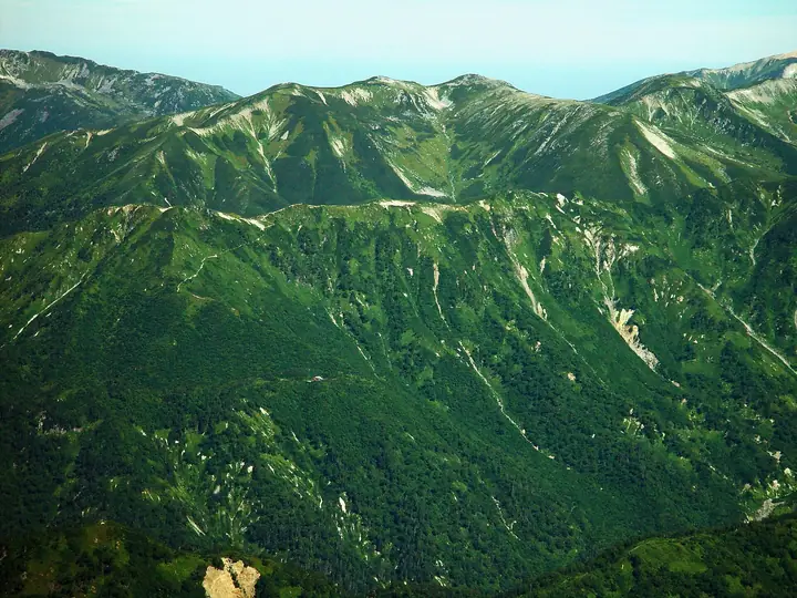
Mount Yumioridake (2,592 m) rises in the southern Hida Mountains (Northern Japanese Alps) in Takayama City, Gifu Prefecture, within Chubu-Sangaku National Park. Its broad, plateau-like summit area offers sweeping views of the Yari–Hotaka range and alpine flower meadows of globeflowers and Hakusan anemones. Listed among the "100 Famous Flower Mountains" (花の百名山) and the "Sequel to the 100 Mountains of Gifu" (続ぎふ百山), it is typically climbed from Shin-Hotaka Onsen via the Koike-shindo trail past Kagamidaira.
Mt. Yumioridake at a glance
- Weather: The most settled day in the next 7 days is Sun, November 8: clear, gusts up to 8 m/s. Sat, Nov 7: strong wind (gusts up to 17 m/s).
- Route: The shortest is Mount Kasa and Kagamidaira Circuit via Kasa-shindo: about 16 h 9 min, 29.4 km, about 2,490 m of climbing.
Mt. Yumioridake weather (hourly, 14 days)
Sunrise today 06:14, sunset 16:53
| Tue, 11/3 | Wed, 11/4 | Thu, 11/5 | Fri, 11/6 | Sat, 11/7 | Sun, 11/8 | Mon, 11/9 | Tue, 11/10 | Wed, 11/11 | Thu, 11/12 | Fri, 11/13 | Sat, 11/14 | Sun, 11/15 | Mon, 11/16 | Tue, 11/17 | |||||||||||||||||||||||||||||||||||||||||||||||||||||||||||||||||||||||
|---|---|---|---|---|---|---|---|---|---|---|---|---|---|---|---|---|---|---|---|---|---|---|---|---|---|---|---|---|---|---|---|---|---|---|---|---|---|---|---|---|---|---|---|---|---|---|---|---|---|---|---|---|---|---|---|---|---|---|---|---|---|---|---|---|---|---|---|---|---|---|---|---|---|---|---|---|---|---|---|---|---|---|---|---|---|
| Japan time | 15 | 17 | 19 | 21 | 23 | 1 | 3 | 5 | 7 | 9 | 11 | 13 | 15 | 18 | 21 | 0 | 3 | 6 | 9 | 12 | 15 | 18 | 21 | 0 | 3 | 6 | 9 | 12 | 15 | 18 | 21 | 0 | 3 | 6 | 9 | 12 | 15 | 18 | 21 | 0 | 3 | 6 | 9 | 12 | 15 | 18 | 21 | 0 | 3 | 6 | 9 | 15 | 21 | 3 | 9 | 15 | 21 | 3 | 9 | 15 | 21 | 3 | 9 | 15 | 21 | 3 | 9 | 15 | 21 | 3 | 9 | 15 | 21 | 3 | 9 | 15 | 21 | 3 | 9 | 15 | 21 | 3 | 9 | 15 | |
  |   |  | | | | | | | |  | |   |   | |   | | |   | | | | | |   | | |   |   | |   | | | |   | | | |   | | |  | | | | |   | | | | |   | | | | | | | | | |  | | | | |   |   | | | | | | | | | | | | | | | | | ||
| Temperature | °C | 2° | -3° | -5° | -5° | -5° | -4° | -3° | -3° | -1° | 4° | 5° | 6° | 5° | 1° | 3° | 2° | 2° | 3° | 4° | 6° | 6° | 3° | 3° | 3° | 2° | 2° | 2° | 3° | 1° | -2° | -4° | -5° | -6° | -7° | -7° | -6° | -7° | -9° | -9° | -9° | -10° | -9° | -1° | 0° | -1° | -5° | -4° | -3° | -3° | -3° | -2° | -1° | -8° | -8° | -2° | -2° | -5° | -10° | -8° | -6° | -9° | -8° | -2° | -2° | -8° | -5° | -5° | -3° | -8° | -7° | 1° | 1° | -5° | -4° | 1° | 1° | 1° | 1° | 2° | -2° | -6° | -4° | -1° | -1° |
| Precipitation | mm | 2.3 | 9 | 8 | 6 | 0.7 | 0.4 | 3.5 | 3.1 | 1.2 | 0.9 | 0.1 | 0.5 | 0.4 | 1.5 | 1.6 | 1.9 | 1.9 | 0.8 | 0.3 | 0.1 | 0.1 | 0.7 | 0.8 | 0.1 | 0.6 | 2.9 | 7 | 4.0 | 0.5 | 1.1 | 3.1 | 0.2 | 0.9 | 10 | 9 | 5.0 | 2.3 | 1.0 | ||||||||||||||||||||||||||||||||||||||||||||||
| New snow | cm | <.1 | <.1 | <.1 | 0.2 | 1.3 | 1.6 | 1.8 | 1.8 | 0.8 | 0.3 | 0.1 | <.1 | <.1 | 0.1 | 0.6 | 0.6 | 0.1 | 0.5 | <.1 | 2.5 | 6.4 | 4.0 | 0.5 | 0.9 | 2.3 | 0.1 | <.1 | <.1 | 0.2 | 0.8 | ||||||||||||||||||||||||||||||||||||||||||||||||||||||
| Snow depth | cm | 0 | 0 | 0 | 0 | 0 | 0 | 0 | 0 | 0 | 0 | 0 | 0 | 0 | 0 | 0 | 0 | 0 | 0 | 0 | 0 | 0 | 0 | 0 | 0 | 0 | 0 | 0 | 0 | 0 | 0 | 0 | 1 | 2 | 3 | 5 | 5 | 5 | 5 | 5 | 5 | 5 | 5 | 5 | 4 | 4 | 4 | 4 | 4 | 5 | 5 | 5 | 5 | 5 | 5 | 4 | 4 | 6 | 11 | 14 | 14 | 13 | 13 | 13 | 12 | 12 | 12 | 14 | 13 | 13 | 13 | 13 | 12 | 11 | 11 | 11 | 9 | 8 | 5 | 4 | 3 | 3 | 3 | 3 | 3 |
| Wind | m/s | 2 | 0 | 0 | 0 | 0 | 1 | 1 | 1 | 1 | 2 | 3 | 3 | 3 | 1 | 2 | 0 | 1 | 1 | 1 | 3 | 3 | 1 | 1 | 1 | 1 | 3 | 3 | 4 | 4 | 4 | 4 | 5 | 4 | 5 | 5 | 5 | 3 | 3 | 2 | 1 | 1 | 1 | 1 | 2 | 0 | 1 | 1 | 1 | 2 | 1 | 1 | 1 | 1 | 1 | 2 | 4 | 2 | 7 | 4 | 3 | 2 | 0 | 2 | 1 | 1 | 2 | 3 | 2 | 1 | 1 | 1 | 1 | 1 | 1 | 2 | 1 | 4 | 2 | 3 | 4 | 2 | 0 | 1 | 2 |
| Wind gusts | m/s | 9 | 8 | 5 | 5 | 4 | 4 | 4 | 3 | 4 | 6 | 8 | 9 | 9 | 8 | 9 | 9 | 7 | 7 | 9 | 11 | 11 | 9 | 7 | 8 | 8 | 9 | 12 | 14 | 14 | 13 | 13 | 14 | 15 | 16 | 16 | 17 | 16 | 13 | 11 | 10 | 9 | 9 | 8 | 8 | 8 | 6 | 6 | 8 | 10 | 10 | 7 | 10 | 6 | 6 | 8 | 14 | 12 | 21 | 22 | 17 | 11 | 7 | 7 | 8 | 5 | 9 | 11 | 11 | 10 | 8 | 5 | 6 | 5 | 6 | 8 | 12 | 17 | 17 | 10 | 14 | 13 | 8 | 4 | 7 |
| Wind dir. | ↓ | ↓ | ↓ | ↓ | ↓ | ↓ | ↓ | ↓ | ↓ | ↓ | ↓ | ↓ | ↓ | ↓ | ↓ | ↓ | ↓ | ↓ | ↓ | ↓ | ↓ | ↓ | ↓ | ↓ | ↓ | ↓ | ↓ | ↓ | ↓ | ↓ | ↓ | ↓ | ↓ | ↓ | ↓ | ↓ | ↓ | ↓ | ↓ | ↓ | ↓ | ↓ | ↓ | ↓ | ↓ | ↓ | ↓ | ↓ | ↓ | ↓ | ↓ | ↓ | ↓ | ↓ | ↓ | ↓ | ↓ | ↓ | ↓ | ↓ | ↓ | ↓ | ↓ | ↓ | ↓ | ↓ | ↓ | ↓ | ↓ | ↓ | ↓ | ↓ | ↓ | ↓ | ↓ | ↓ | ↓ | ↓ | ↓ | ↓ | ↓ | ↓ | ↓ | ↓ | |
Mt. Yumioridake hiking routes
- Mount Kasa and Kagamidaira Circuit via Kasa-shindo 29.4 km · Ascent 2,493 m Shinhotaka Onsen Bus Stop (Bus stop), Shinhotaka Ropeway Bus Stop (Bus stop), 深山荘 登山者用駐車場
- Mount Sugoroku, Mitsumatarenge, and Washiba Out-and-Back from Shinhotaka 38.4 km · Ascent 2,931 m Shinhotaka Onsen Bus Stop (Bus stop), Shinhotaka Ropeway Bus Stop (Bus stop), 深山荘 登山者用駐車場
Hiking times are estimates calculated from the terrain.
Huts, campsites and lodging near Mt. Yumioridake
Mountain huts
- 鏡平山荘 2026: open July 10–October 15 · reservation required · sleeps 110
- Sugoroku Goya 2026: open July 10–October 20 · reservation required · sleeps 150
- Yaridaira Goya 2026: open July 10–October 12 · reservation required · sleeps 80
- Wasabidaira Goya 2026: open July 10–October 20 · reservation required · sleeps 65
- Yarigatake Sanso 2026: open April 27–November 3 · reservation required · sleeps 300
Campsites
- 双六小屋テント場
- 槍平小屋テン場
- わさび平小屋テント場
- 殺生ヒュッテテント場
Lists that include Mt. Yumioridake
100 Famous Mountains of Flowers · Elevations of 1003 Mountains of Japan
Mt. Yumioridake facts
- Elevation
- 2,592 m
- Location
- Takayama, Gifu
36.349520, 137.596523 - National Park
- 中部山岳国立公園
- Website
- www.sugorokugoya.com
- Trail Map
- www.sugorokugoya.com
- Access Information
- www.sugorokugoya.com
- Wikipedia
- ja.wikipedia.org