
Mt. Tarouyama
太郎山
Toyama, Toyama · Elevation 2,373 m
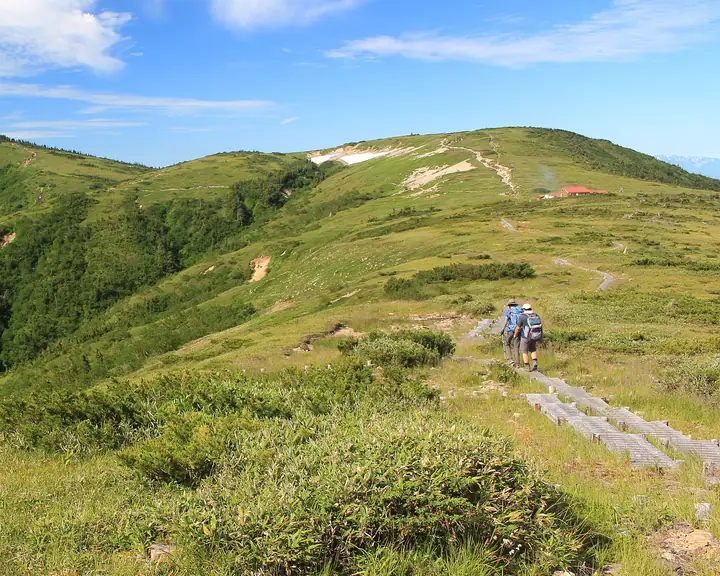
Tarouyama is a 2,372.9-meter peak in Toyama City, Toyama Prefecture, on the southwestern ridge extending from Mount Yakushi in the western Northern Japan Alps. At its base spreads the broad alpine plateau of Taro-bei-daira, where Tarodaira Goya stands at the junction of routes leading to Yakushi-dake, Kumonodaira, and Kurobe-Goro-dake. The peak lies within Chubu Sangaku National Park and is listed in the New Hundred Flower Mountains of Japan.
Mt. Tarouyama at a glance
- Weather: The most settled day in the next 7 days is Sun, November 8: clear, gusts up to 9 m/s. Thu, Nov 5, Sat, Nov 7: strong wind (gusts up to 17 m/s).
Mt. Tarouyama weather (hourly, 14 days)
Sunrise today 06:14, sunset 16:53
| Tue, 11/3 | Wed, 11/4 | Thu, 11/5 | Fri, 11/6 | Sat, 11/7 | Sun, 11/8 | Mon, 11/9 | Tue, 11/10 | Wed, 11/11 | Thu, 11/12 | Fri, 11/13 | Sat, 11/14 | Sun, 11/15 | Mon, 11/16 | Tue, 11/17 | |||||||||||||||||||||||||||||||||||||||||||||||||||||||||||||||||||||||
|---|---|---|---|---|---|---|---|---|---|---|---|---|---|---|---|---|---|---|---|---|---|---|---|---|---|---|---|---|---|---|---|---|---|---|---|---|---|---|---|---|---|---|---|---|---|---|---|---|---|---|---|---|---|---|---|---|---|---|---|---|---|---|---|---|---|---|---|---|---|---|---|---|---|---|---|---|---|---|---|---|---|---|---|---|---|
| Japan time | 15 | 17 | 19 | 21 | 23 | 1 | 3 | 5 | 7 | 9 | 11 | 13 | 15 | 18 | 21 | 0 | 3 | 6 | 9 | 12 | 15 | 18 | 21 | 0 | 3 | 6 | 9 | 12 | 15 | 18 | 21 | 0 | 3 | 6 | 9 | 12 | 15 | 18 | 21 | 0 | 3 | 6 | 9 | 12 | 15 | 18 | 21 | 0 | 3 | 6 | 9 | 15 | 21 | 3 | 9 | 15 | 21 | 3 | 9 | 15 | 21 | 3 | 9 | 15 | 21 | 3 | 9 | 15 | 21 | 3 | 9 | 15 | 21 | 3 | 9 | 15 | 21 | 3 | 9 | 15 | 21 | 3 | 9 | 15 | |
  |  |   | | | | | | | |  | |   |   | |   | | |   | | | | | | | | |   | |   | |   | | |   | | | | |   | |  | | | | |   | | | | |   | | | | | | | | |   |  | | | | |   |   | | | | | | | | | | | | |   | | | | ||
| Temperature | °C | 2° | -2° | -5° | -4° | -3° | -3° | -2° | -2° | -1° | 5° | 7° | 7° | 6° | 2° | 4° | 4° | 3° | 4° | 5° | 7° | 8° | 4° | 4° | 4° | 4° | 3° | 3° | 3° | 1° | -1° | -3° | -4° | -5° | -6° | -6° | -5° | -6° | -8° | -9° | -10° | -10° | -8° | 0° | 0° | 0° | -4° | -3° | -2° | -2° | -2° | -1° | -1° | -9° | -9° | 0° | -1° | -4° | -9° | -7° | -6° | -7° | -9° | -1° | -1° | -8° | -4° | -4° | -3° | -8° | -7° | 2° | 3° | -5° | -4° | 3° | 2° | 3° | 3° | 3° | -1° | -6° | -5° | 0° | 1° |
| Precipitation | mm | 1.8 | 9 | 8 | 6 | 1.0 | 0.7 | 1.9 | 2.8 | 1.5 | 1.5 | 0.7 | 1.5 | 0.8 | 3.3 | 2.9 | 2.7 | 2.8 | 1.3 | 0.5 | 0.1 | 0.1 | 0.3 | 1.2 | 1.4 | 0.1 | 1.2 | 3.6 | 9 | 6 | 1.5 | 2.1 | 4.9 | 0.3 | 0.9 | 9 | 8 | 6 | 6 | 3.1 | |||||||||||||||||||||||||||||||||||||||||||||
| New snow | cm | 0.3 | 0.4 | 2.7 | 2.8 | 2.7 | 2.8 | 1.3 | 0.5 | 0.1 | <.1 | 0.1 | 0.3 | 1.2 | 1.1 | <.1 | 1.1 | <.1 | 3.2 | 8.6 | 6.1 | 1.5 | <.1 | 2.0 | 3.9 | 0.3 | 0.1 | 1.5 | 2.0 | ||||||||||||||||||||||||||||||||||||||||||||||||||||||||
| Snow depth | cm | 0 | 0 | 0 | 0 | 0 | 0 | 0 | 0 | 0 | 0 | 0 | 0 | 0 | 0 | 0 | 0 | 0 | 0 | 0 | 0 | 0 | 0 | 0 | 0 | 0 | 0 | 0 | 0 | 0 | 0 | <1 | 2 | 5 | 7 | 9 | 10 | 10 | 10 | 10 | 10 | 9 | 9 | 9 | 9 | 8 | 8 | 8 | 8 | 9 | 9 | 9 | 9 | 8 | 8 | 8 | 8 | 10 | 17 | 22 | 22 | 21 | 21 | 20 | 19 | 19 | 20 | 23 | 23 | 22 | 22 | 21 | 20 | 20 | 20 | 19 | 17 | 15 | 13 | 11 | 11 | 12 | 12 | 12 | 12 |
| Wind | m/s | 1 | 0 | 1 | 1 | 1 | 1 | 1 | 1 | 1 | 2 | 3 | 3 | 3 | 2 | 3 | 0 | 1 | 1 | 2 | 4 | 3 | 1 | 3 | 3 | 2 | 3 | 3 | 4 | 4 | 4 | 4 | 4 | 4 | 4 | 4 | 4 | 3 | 2 | 0 | 1 | 1 | 1 | 1 | 2 | 0 | 2 | 2 | 2 | 3 | 3 | 2 | 0 | 1 | 1 | 3 | 4 | 3 | 7 | 4 | 3 | 1 | 0 | 1 | 1 | 1 | 2 | 3 | 2 | 1 | 0 | 1 | 1 | 2 | 2 | 3 | 3 | 6 | 3 | 2 | 3 | 1 | 0 | 1 | 2 |
| Wind gusts | m/s | 9 | 7 | 6 | 5 | 5 | 5 | 5 | 5 | 6 | 8 | 10 | 11 | 11 | 11 | 12 | 12 | 7 | 9 | 14 | 17 | 16 | 11 | 11 | 12 | 12 | 11 | 12 | 13 | 15 | 14 | 15 | 14 | 15 | 16 | 16 | 17 | 17 | 14 | 11 | 10 | 9 | 9 | 9 | 9 | 8 | 8 | 10 | 11 | 13 | 13 | 11 | 11 | 6 | 6 | 11 | 16 | 15 | 24 | 25 | 17 | 13 | 7 | 8 | 11 | 6 | 9 | 12 | 11 | 11 | 10 | 6 | 8 | 7 | 10 | 13 | 17 | 22 | 22 | 14 | 13 | 13 | 7 | 5 | 8 |
| Wind dir. | ↓ | ↓ | ↓ | ↓ | ↓ | ↓ | ↓ | ↓ | ↓ | ↓ | ↓ | ↓ | ↓ | ↓ | ↓ | ↓ | ↓ | ↓ | ↓ | ↓ | ↓ | ↓ | ↓ | ↓ | ↓ | ↓ | ↓ | ↓ | ↓ | ↓ | ↓ | ↓ | ↓ | ↓ | ↓ | ↓ | ↓ | ↓ | ↓ | ↓ | ↓ | ↓ | ↓ | ↓ | ↓ | ↓ | ↓ | ↓ | ↓ | ↓ | ↓ | ↓ | ↓ | ↓ | ↓ | ↓ | ↓ | ↓ | ↓ | ↓ | ↓ | ↓ | ↓ | ↓ | ↓ | ↓ | ↓ | ↓ | ↓ | ↓ | ↓ | ↓ | ↓ | ↓ | ↓ | ↓ | ↓ | ↓ | ↓ | ↓ | ↓ | ↓ | ↓ | ↓ | |
Huts, campsites and lodging near Mt. Tarouyama
Mountain huts
- Tarodairakoya 2026: open June 6–October 18 · reservation required · sleeps 150
- Yakushidake Sanso 2026: open July 1–October 4 · reservation required · sleeps 80
- 北ノ俣避難小屋 temporarily closed
- 薬師沢小屋 2026: open July 1–October 8 · reservation required · sleeps 50
Campsites
- Tarodaira Campground
Lists that include Mt. Tarouyama
Mt. Tarouyama facts
- Elevation
- 2,373 m
- Location
- Toyama, Toyama
36.447281, 137.513584 - National Park
- 中部山岳国立公園
- Website
- ltaro.com
- Trail Map
- ltaro.com
- Wikipedia
- ja.wikipedia.org