
Mt. Jiidake
祖父岳
Toyama, Toyama · Elevation 2,825 m
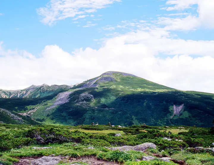
Mt. Jiidake is a 2,825 m peak in Toyama City, Toyama Prefecture, set within Chūbu-Sangaku National Park at the eastern edge of the Kumonodaira lava plateau in the heart of the Hida Mountains' Kurobe headwaters. The summit sits on an old volcanic dome of andesite and dacite whose gentle slopes can be disorienting in poor weather. It is a key junction on the trail network linking the Kumonodaira Sansō hut, Iwatake-norikoshi pass, Suishō hut and Mitsumata Sansō below Mt. Washiba, and is one of the signature summits of the Kumonodaira plateau — the region known as the "last frontier" of the Northern Alps. The peak appears on the Japan Top 100 High Mountains and Toyama 100 Mountains lists.
Mt. Jiidake at a glance
- Weather: The most settled day in the next 7 days is Sun, November 8: clear, gusts up to 9 m/s. Thu, Nov 5, Sat, Nov 7: strong wind (gusts up to 17 m/s).
Mt. Jiidake weather (hourly, 14 days)
Sunrise today 06:14, sunset 16:53
| Tue, 11/3 | Wed, 11/4 | Thu, 11/5 | Fri, 11/6 | Sat, 11/7 | Sun, 11/8 | Mon, 11/9 | Tue, 11/10 | Wed, 11/11 | Thu, 11/12 | Fri, 11/13 | Sat, 11/14 | Sun, 11/15 | Mon, 11/16 | Tue, 11/17 | |||||||||||||||||||||||||||||||||||||||||||||||||||||||||||||||||||||||
|---|---|---|---|---|---|---|---|---|---|---|---|---|---|---|---|---|---|---|---|---|---|---|---|---|---|---|---|---|---|---|---|---|---|---|---|---|---|---|---|---|---|---|---|---|---|---|---|---|---|---|---|---|---|---|---|---|---|---|---|---|---|---|---|---|---|---|---|---|---|---|---|---|---|---|---|---|---|---|---|---|---|---|---|---|---|
| Japan time | 15 | 17 | 19 | 21 | 23 | 1 | 3 | 5 | 7 | 9 | 11 | 13 | 15 | 18 | 21 | 0 | 3 | 6 | 9 | 12 | 15 | 18 | 21 | 0 | 3 | 6 | 9 | 12 | 15 | 18 | 21 | 0 | 3 | 6 | 9 | 12 | 15 | 18 | 21 | 0 | 3 | 6 | 9 | 12 | 15 | 18 | 21 | 0 | 3 | 6 | 9 | 15 | 21 | 3 | 9 | 15 | 21 | 3 | 9 | 15 | 21 | 3 | 9 | 15 | 21 | 3 | 9 | 15 | 21 | 3 | 9 | 15 | 21 | 3 | 9 | 15 | 21 | 3 | 9 | 15 | 21 | 3 | 9 | 15 | |
  |  |   | | | | | | | |  | |   |   | |   | | |   | | | | | | | | |   | |   | |   | | |   | | | | |   | |  | | | | |   | | | | |   | | | | | | | | |   |  | | | | |   |   | | | | | | | | | | | | |   | | | | ||
| Temperature | °C | -1° | -5° | -7° | -7° | -6° | -6° | -5° | -5° | -4° | 2° | 4° | 4° | 3° | -1° | 1° | 1° | 0° | 1° | 2° | 4° | 5° | 1° | 2° | 1° | 1° | 0° | 0° | 0° | -1° | -4° | -6° | -7° | -8° | -9° | -9° | -8° | -8° | -11° | -12° | -12° | -13° | -10° | -3° | -3° | -3° | -7° | -6° | -5° | -5° | -5° | -4° | -4° | -12° | -12° | -3° | -4° | -7° | -12° | -10° | -9° | -10° | -11° | -4° | -4° | -11° | -7° | -7° | -6° | -11° | -10° | -1° | 0° | -8° | -7° | 0° | -1° | 0° | 0° | 0° | -4° | -9° | -8° | -3° | -2° |
| Precipitation | mm | 1.8 | 9 | 8 | 6 | 1.0 | 0.7 | 1.9 | 2.8 | 1.5 | 1.5 | 0.7 | 1.5 | 0.8 | 3.3 | 2.9 | 2.7 | 2.8 | 1.3 | 0.5 | 0.1 | 0.1 | 0.3 | 1.2 | 1.4 | 0.1 | 1.2 | 3.6 | 9 | 6 | 1.5 | 2.1 | 4.9 | 0.3 | 0.9 | 9 | 8 | 6 | 6 | 3.1 | |||||||||||||||||||||||||||||||||||||||||||||
| New snow | cm | 0.3 | 0.4 | 2.7 | 2.8 | 2.7 | 2.8 | 1.3 | 0.5 | 0.1 | <.1 | 0.1 | 0.3 | 1.2 | 1.1 | <.1 | 1.1 | <.1 | 3.2 | 8.6 | 6.1 | 1.5 | <.1 | 2.0 | 3.9 | 0.3 | 0.1 | 1.5 | 2.0 | ||||||||||||||||||||||||||||||||||||||||||||||||||||||||
| Snow depth | cm | 0 | 0 | 0 | 0 | 0 | 0 | 0 | 0 | 0 | 0 | 0 | 0 | 0 | 0 | 0 | 0 | 0 | 0 | 0 | 0 | 0 | 0 | 0 | 0 | 0 | 0 | 0 | 0 | 0 | 0 | <1 | 2 | 5 | 7 | 9 | 10 | 10 | 10 | 10 | 10 | 9 | 9 | 9 | 9 | 8 | 8 | 8 | 8 | 9 | 9 | 9 | 9 | 8 | 8 | 8 | 8 | 10 | 17 | 22 | 22 | 21 | 21 | 20 | 19 | 19 | 20 | 23 | 23 | 22 | 22 | 21 | 20 | 20 | 20 | 19 | 17 | 15 | 13 | 11 | 11 | 12 | 12 | 12 | 12 |
| Wind | m/s | 1 | 0 | 1 | 1 | 1 | 1 | 1 | 1 | 1 | 2 | 3 | 3 | 3 | 2 | 3 | 0 | 1 | 1 | 2 | 4 | 3 | 1 | 3 | 3 | 2 | 3 | 3 | 4 | 4 | 4 | 4 | 4 | 4 | 4 | 4 | 4 | 3 | 2 | 0 | 1 | 1 | 1 | 1 | 2 | 0 | 2 | 2 | 2 | 3 | 3 | 2 | 0 | 1 | 1 | 3 | 4 | 3 | 7 | 4 | 3 | 1 | 0 | 1 | 1 | 1 | 2 | 3 | 2 | 1 | 0 | 1 | 1 | 2 | 2 | 3 | 3 | 6 | 3 | 2 | 3 | 1 | 0 | 1 | 2 |
| Wind gusts | m/s | 9 | 7 | 6 | 5 | 5 | 5 | 5 | 5 | 6 | 8 | 10 | 11 | 11 | 11 | 12 | 12 | 7 | 9 | 14 | 17 | 16 | 11 | 11 | 12 | 12 | 11 | 12 | 13 | 15 | 14 | 15 | 14 | 15 | 16 | 16 | 17 | 17 | 14 | 11 | 10 | 9 | 9 | 9 | 9 | 8 | 8 | 10 | 11 | 13 | 13 | 11 | 11 | 6 | 6 | 11 | 16 | 15 | 24 | 25 | 17 | 13 | 7 | 8 | 11 | 6 | 9 | 12 | 11 | 11 | 10 | 6 | 8 | 7 | 10 | 13 | 17 | 22 | 22 | 14 | 13 | 13 | 7 | 5 | 8 |
| Wind dir. | ↓ | ↓ | ↓ | ↓ | ↓ | ↓ | ↓ | ↓ | ↓ | ↓ | ↓ | ↓ | ↓ | ↓ | ↓ | ↓ | ↓ | ↓ | ↓ | ↓ | ↓ | ↓ | ↓ | ↓ | ↓ | ↓ | ↓ | ↓ | ↓ | ↓ | ↓ | ↓ | ↓ | ↓ | ↓ | ↓ | ↓ | ↓ | ↓ | ↓ | ↓ | ↓ | ↓ | ↓ | ↓ | ↓ | ↓ | ↓ | ↓ | ↓ | ↓ | ↓ | ↓ | ↓ | ↓ | ↓ | ↓ | ↓ | ↓ | ↓ | ↓ | ↓ | ↓ | ↓ | ↓ | ↓ | ↓ | ↓ | ↓ | ↓ | ↓ | ↓ | ↓ | ↓ | ↓ | ↓ | ↓ | ↓ | ↓ | ↓ | ↓ | ↓ | ↓ | ↓ | |
Huts, campsites and lodging near Mt. Jiidake
Mountain huts
- 雲ノ平山荘 2026: open July 1–October 15 · reservation required · sleeps 60
- Suisho Hut 2026: open July 10–September 30 · reservation required · sleeps 38
- Mitsumatasanso 2026: open July 4–October 15 · reservation required
- 高天原山荘 2026: open July 5–September 30 · reservation required · sleeps 45
- Kurobegorogoya 2026: open July 10–October 15 · reservation required · sleeps 60
Campsites
- 雲ノ平キャンプ場
- 三俣蓮華岳テント場
- 黒部五郎キャンプ場
- 双六小屋テント場
Lists that include Mt. Jiidake
Japan's 100 Highest Mountains · 100 Mountains of Toyama · Elevations of 1003 Mountains of Japan · 1000 Mountains of Japan
Mt. Jiidake facts
- Elevation
- 2,825 m
- Location
- Toyama, Toyama
36.411181, 137.591164 - National Park
- 中部山岳国立公園
- Website
- kumonodaira.com
- Wikipedia
- ja.wikipedia.org