
Mount Kongō
金剛山
Gose, Nara · Elevation 1,125 m
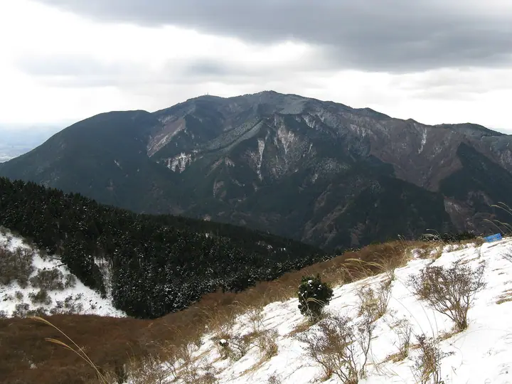
Mount Kongō, 1,125 m, is the main peak of the Kongō Range straddling Gose City (Nara) and Chihaya-Akasaka Village (Osaka). A sacred mountain of the Shugendō tradition, it is said to have been opened by En no Ozunu, who founded Tenporin-ji temple at its summit; today the peak holds Katsuragi Shrine and the Kuni-mi Castle ruins. It lies within Kongō-Ikoma-Kisen Quasi-National Park, anchors the Diamond Trail, and is counted among the 200 Famous Mountains of Japan.
Mount Kongō at a glance
- Weather: The most settled day in the next 7 days is Thu, November 5: clear, gusts up to 4 m/s.
- Route: The shortest is Mount Kongo Loop via Teradani and Monju Ridge from Hyakugatsuji: about 2 h 40 min, 4.4 km, about 470 m of climbing.
Mount Kongō weather (hourly, 14 days)
Sunrise today 06:19, sunset 17:03
| Tue, 11/3 | Wed, 11/4 | Thu, 11/5 | Fri, 11/6 | Sat, 11/7 | Sun, 11/8 | Mon, 11/9 | Tue, 11/10 | Wed, 11/11 | Thu, 11/12 | Fri, 11/13 | Sat, 11/14 | Sun, 11/15 | Mon, 11/16 | Tue, 11/17 | |||||||||||||||||||||||||||||||||||||||||||||||||||||||||||||||||||||||
|---|---|---|---|---|---|---|---|---|---|---|---|---|---|---|---|---|---|---|---|---|---|---|---|---|---|---|---|---|---|---|---|---|---|---|---|---|---|---|---|---|---|---|---|---|---|---|---|---|---|---|---|---|---|---|---|---|---|---|---|---|---|---|---|---|---|---|---|---|---|---|---|---|---|---|---|---|---|---|---|---|---|---|---|---|---|
| Japan time | 21 | 23 | 1 | 3 | 5 | 7 | 9 | 11 | 13 | 15 | 17 | 19 | 21 | 0 | 3 | 6 | 9 | 12 | 15 | 18 | 21 | 0 | 3 | 6 | 9 | 12 | 15 | 18 | 21 | 0 | 3 | 6 | 9 | 12 | 15 | 18 | 21 | 0 | 3 | 6 | 9 | 12 | 15 | 18 | 21 | 0 | 3 | 6 | 9 | 12 | 15 | 21 | 3 | 9 | 15 | 21 | 3 | 9 | 15 | 21 | 3 | 9 | 15 | 21 | 3 | 9 | 15 | 21 | 3 | 9 | 15 | 21 | 3 | 9 | 15 | 21 | 3 | 9 | 15 | 21 | 3 | 9 | 15 | 21 | |
  |   |  | | |   | |   | | |   | | |   | |   |   |   | |   |   | | | | | |  |  | | | | | | | | | | | | | | | | | | | | | | | | |   | | | | | | | |  | | | | | | | | | | | | | |   | | | | | |  | | | | ||
| Temperature | °C | 8° | 7° | 6° | 5° | 5° | 6° | 10° | 11° | 12° | 13° | 11° | 11° | 10° | 9° | 9° | 9° | 11° | 14° | 16° | 13° | 11° | 10° | 12° | 10° | 12° | 14° | 14° | 11° | 8° | 7° | 5° | 4° | 8° | 9° | 9° | 5° | 3° | 2° | 1° | 2° | 5° | 8° | 9° | 6° | 6° | 5° | 4° | 4° | 7° | 10° | 11° | 6° | 2° | 9° | 11° | 6° | 4° | 6° | 8° | 3° | 0° | 6° | 9° | 2° | 3° | 7° | 9° | 3° | -1° | 6° | 11° | 4° | 2° | 10° | 14° | 9° | 8° | 11° | 12° | 6° | 2° | 5° | 9° | 3° |
| Precipitation | mm | 0.8 | 0.2 | 0.4 | 0.2 | 1.4 | 1.5 | 7 | 7 | 0.7 | 1.1 | 0.6 | 0.1 | 0.2 | 0.2 | 0.2 | 0.2 | 1.8 | 25 | 0.5 | 1.3 | 0.2 | |||||||||||||||||||||||||||||||||||||||||||||||||||||||||||||||
| New snow | cm | – | – | – | |||||||||||||||||||||||||||||||||||||||||||||||||||||||||||||||||||||||||||||||||
| Snow depth | cm | 0 | 0 | 0 | 0 | 0 | 0 | 0 | 0 | 0 | 0 | 0 | 0 | 0 | 0 | 0 | 0 | 0 | 0 | 0 | 0 | 0 | 0 | 0 | 0 | 0 | 0 | 0 | 0 | 0 | 0 | 0 | 0 | 0 | 0 | 0 | 0 | 0 | 0 | 0 | 0 | 0 | 0 | 0 | 0 | 0 | 0 | 0 | 0 | 0 | 0 | 0 | 0 | 0 | 0 | 0 | 0 | 0 | 0 | 0 | 0 | 0 | 0 | 0 | 0 | 0 | 0 | 0 | 0 | 0 | 0 | 0 | 0 | 0 | 0 | 0 | 0 | 0 | 0 | 0 | 0 | 0 | 0 | 0 | 0 |
| Wind | m/s | 0 | 0 | 0 | 0 | 1 | 1 | 1 | 1 | 2 | 2 | 2 | 2 | 2 | 1 | 1 | 1 | 0 | 0 | 1 | 1 | 0 | 1 | 3 | 1 | 4 | 5 | 5 | 2 | 2 | 2 | 2 | 1 | 3 | 4 | 5 | 2 | 1 | 1 | 1 | 0 | 1 | 3 | 2 | 1 | 0 | 0 | 1 | 1 | 1 | 1 | 1 | 0 | 1 | 2 | 3 | 2 | 4 | 4 | 5 | 1 | 1 | 1 | 1 | 1 | 2 | 2 | 4 | 1 | 1 | 0 | 1 | 1 | 1 | 1 | 1 | 0 | 1 | 2 | 4 | 2 | 1 | 1 | 1 | 1 |
| Wind gusts | m/s | 4 | 2 | 2 | 3 | 3 | 3 | 5 | 6 | 6 | 6 | 6 | 6 | 6 | 6 | 4 | 3 | 3 | 3 | 4 | 3 | 6 | 7 | 9 | 9 | 10 | 12 | 14 | 13 | 8 | 8 | 7 | 6 | 9 | 11 | 12 | 12 | 8 | 4 | 4 | 4 | 4 | 8 | 8 | 5 | 3 | 2 | 2 | 3 | 3 | 6 | 5 | 6 | 3 | 6 | 9 | 8 | 11 | 11 | 14 | 12 | 4 | 3 | 6 | 4 | 6 | 7 | 11 | 10 | 3 | 4 | 4 | 3 | 4 | 5 | 6 | 6 | 8 | 8 | 12 | 11 | 7 | 4 | 7 | 4 |
| Wind dir. | ↓ | ↓ | ↓ | ↓ | ↓ | ↓ | ↓ | ↓ | ↓ | ↓ | ↓ | ↓ | ↓ | ↓ | ↓ | ↓ | ↓ | ↓ | ↓ | ↓ | ↓ | ↓ | ↓ | ↓ | ↓ | ↓ | ↓ | ↓ | ↓ | ↓ | ↓ | ↓ | ↓ | ↓ | ↓ | ↓ | ↓ | ↓ | ↓ | ↓ | ↓ | ↓ | ↓ | ↓ | ↓ | ↓ | ↓ | ↓ | ↓ | ↓ | ↓ | ↓ | ↓ | ↓ | ↓ | ↓ | ↓ | ↓ | ↓ | ↓ | ↓ | ↓ | ↓ | ↓ | ↓ | ↓ | ↓ | ↓ | ↓ | ↓ | ↓ | ↓ | ↓ | ↓ | ↓ | ↓ | ↓ | ↓ | ↓ | ↓ | ↓ | ↓ | ↓ | ↓ | |
Mount Kongō hiking routes
- Mount Kongo Loop via Teradani and Monju Ridge from Hyakugatsuji 4.4 km · Ascent 472 m 百ヶ辻, Chihaya Ropeway mae (Mt Kongo Ropeway) (Bus station), Ropeway mae (Station) (Bus station), Kongosan Ropeway mae (Mt Kongo Ropeway) (Bus stop)
- Kongōsan via Teratani and Chihaya Hondō 4.8 km · Ascent 472 m 百ヶ辻, Chihaya Ropeway mae (Mt Kongo Ropeway) (Bus station), Ropeway mae (Station) (Bus station), Kongosan Ropeway mae (Mt Kongo Ropeway) (Bus stop) → parking
- Mount Kongo Loop via Kurotogadani and Chihaya Hondo 5.5 km · Ascent 570 m Kongo Tozanguchi (Trailhead) (Bus stop) (parking)
- Mount Kongō Circuit via Chihaya Main Trail and Takahata Valley 5.7 km · Ascent 574 m Kongo Tozanguchi (Trailhead) (Bus stop) (parking)
- Mount Kongo via Chihaya Main Trail 6.1 km · Ascent 592 m Kongo Tozanguchi (Trailhead) (Bus stop) (parking)
- Mount Kongo Wildflower Trail 6.7 km · Ascent 614 m Kongo Tozanguchi (Trailhead) (Bus stop) (parking) → Chihaya Ropeway mae (Mt Kongo Ropeway) (Bus station), Ropeway mae (Station) (Bus station), Kongosan Ropeway mae (Mt Kongo Ropeway) (Bus stop) (parking)
- Mount Kongo Round Trip via Fushimi Pass and Chihaya-enchi from Mogatsuji 8.1 km · Ascent 538 m 百ヶ辻, Chihaya Ropeway mae (Mt Kongo Ropeway) (Bus station), Ropeway mae (Station) (Bus station), Kongosan Ropeway mae (Mt Kongo Ropeway) (Bus stop)
- Momiji Valley, Mount Kongō and Mount Dainichi Circuit from Mizukoshi Pass 8.6 km · Ascent 635 m Mizukoshitoge Pass (Bus) (Bus stop), 水越無料駐車場 (parking)
- Kongōsan via Momijidani and the Taiō Ridge 8.2 km · Ascent 693 m 水越無料駐車場, Mizukoshitoge Pass (Bus) (Bus stop) (parking)
- Mount Kongo Loop from Mizukoshi Pass up Momiji Valley and down via Dainichidake 9.9 km · Ascent 668 m Mizukoshitoge Pass (Bus) (Bus stop), 水越無料駐車場 (parking)
- Mount Kongō Return from Takamahiko Shrine 7.4 km · Ascent 726 m parking
- Mount Kongo Return via Taobi East Ridge and Mount Dainichi 7.1 km · Ascent 699 m 水越無料駐車場, Mizukoshitoge Pass (Bus) (Bus stop) (parking)
- Mount Dainichi and Mount Kongō Circuit from Mizukoshi Pass 9.9 km · Ascent 683 m Mizukoshitoge Pass (Bus) (Bus stop), 水越無料駐車場 (parking)
- Mount Kongō and Katsuragi Shrine Loop from Mizukoshi Pass 10.6 km · Ascent 693 m 水越無料駐車場, Mizukoshitoge Pass (Bus) (Bus stop) (parking)
- Mount Kongo Circuit via Taio Ridge and Aogedori Trail 8.9 km · Ascent 809 m Katsuragi trailhead (Bus) (Bus stop)
- Mount Kongo Loop from Mizukoshi Pass, up the Aokuzure Trail and down the Diamond Trail 11.0 km · Ascent 781 m 水越無料駐車場, Mizukoshitoge Pass (Bus) (Bus stop) (parking)
- Mount Kongo and Yushutsudake via Amagataki Trail 9.5 km · Ascent 779 m
- Kongo Range Loop from the Azalea Highland of Katsuragi by Mizukoshi Pass to Kongo's Summit Shrine 16.0 km · Ascent 1,281 m Katsuragi trailhead (Bus) (Bus stop)
- Diamond Trail: Amami Station to Mount Kongo Return 32.4 km · Ascent 1,960 m 天見駅 (Station), Amami (Station) (parking)
Hiking times are estimates calculated from the terrain.
Huts, campsites and lodging near Mount Kongō
Mountain huts
- Konan-sou (CLOSED)
Campsites
- Chihayaenchi Kongosan Campground
- 葛城高原キャンプ場
Lists that include Mount Kongō
Japan 200 Famous Mountains · Japan's 300 Famous Mountains · Illustrated Collection of Japan's Famous Mountains · Kansai 100 Famous Mountains · Kinki 100 Famous Mountains · Osaka 50 Mountains · Nara 100 Mountains to Explore · Diamond Trail · Elevations of 1003 Mountains of Japan · 1000 Mountains of Japan
Mount Kongō facts
- Also known as
- 国見城跡 · 山頂広場 · 葛城山 · 高天山
- Elevation
- 1,125 m
- Location
- Gose, Nara
34.420894, 135.670681 - National Park
- 金剛生駒紀泉国定公園
- Website
- www.city.gose.nara.jp
- Trail Map
- www.city.gose.nara.jp
- Access Information
- www.city.gose.nara.jp
- Wikipedia
- ja.wikipedia.org