
Yūshutsudake
湧出岳
Gose, Nara · Elevation 1,112 m
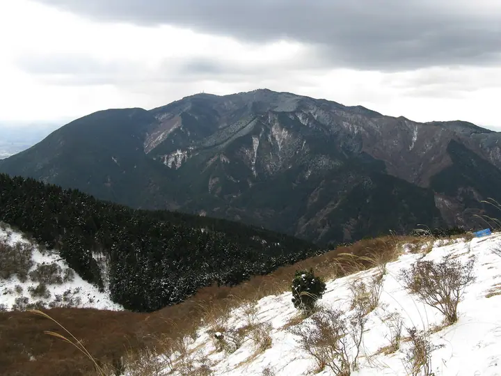
Yūshutsudake (1,112 m) lies in Gose City, Nara Prefecture, just south-east of Mount Katsuragi-dake (1,125 m)—the highest summit of the Kongō range. It hosts the Class-I triangulation point named 'Kongōsan' from which it takes both its rank as one of the Ichitō-sankakuten Hyakumeizan (100 mountains with first-order survey points) and its alternate name. The peak lies within Kongō-Ikoma-Kisen Quasi-National Park and is a key stop on the Diamond Trail linking Mounts Nijō, Katsuragi and Kongō.
Yūshutsudake at a glance
- Weather: The most settled day in the next 7 days is Thu, November 5: cloudy, gusts up to 4 m/s.
- Route: The shortest is Mount Kongo Wildflower Trail: about 3 h 35 min, 6.7 km, about 610 m of climbing.
Yūshutsudake weather (hourly, 14 days)
Sunrise today 06:18, sunset 17:03
| Tue, 11/3 | Wed, 11/4 | Thu, 11/5 | Fri, 11/6 | Sat, 11/7 | Sun, 11/8 | Mon, 11/9 | Tue, 11/10 | Wed, 11/11 | Thu, 11/12 | Fri, 11/13 | Sat, 11/14 | Sun, 11/15 | Mon, 11/16 | Tue, 11/17 | |||||||||||||||||||||||||||||||||||||||||||||||||||||||||||||||||||||||
|---|---|---|---|---|---|---|---|---|---|---|---|---|---|---|---|---|---|---|---|---|---|---|---|---|---|---|---|---|---|---|---|---|---|---|---|---|---|---|---|---|---|---|---|---|---|---|---|---|---|---|---|---|---|---|---|---|---|---|---|---|---|---|---|---|---|---|---|---|---|---|---|---|---|---|---|---|---|---|---|---|---|---|---|---|---|
| Japan time | 15 | 17 | 19 | 21 | 23 | 1 | 3 | 5 | 7 | 9 | 11 | 13 | 15 | 18 | 21 | 0 | 3 | 6 | 9 | 12 | 15 | 18 | 21 | 0 | 3 | 6 | 9 | 12 | 15 | 18 | 21 | 0 | 3 | 6 | 9 | 12 | 15 | 18 | 21 | 0 | 3 | 6 | 9 | 12 | 15 | 18 | 21 | 0 | 3 | 6 | 9 | 15 | 21 | 3 | 9 | 15 | 21 | 3 | 9 | 15 | 21 | 3 | 9 | 15 | 21 | 3 | 9 | 15 | 21 | 3 | 9 | 15 | 21 | 3 | 9 | 15 | 21 | 3 | 9 | 15 | 21 | 3 | 9 | 15 | |
  | |   |   | | | | | |   | | | | |   |   |   | | |   |  | | | | | |   | | |  | | | | | |   | | | | | | | | | | | | | | | | |   |   | | | | | | | |  | | | | | | | | | | | | | |   | | | | | |  | | | ||
| Temperature | °C | 14° | 11° | 9° | 8° | 8° | 6° | 5° | 4° | 5° | 9° | 11° | 14° | 14° | 10° | 10° | 10° | 9° | 9° | 12° | 14° | 15° | 12° | 11° | 9° | 12° | 11° | 12° | 14° | 14° | 11° | 8° | 7° | 5° | 5° | 8° | 9° | 9° | 5° | 3° | 2° | 1° | 0° | 7° | 10° | 9° | 6° | 6° | 5° | 4° | 4° | 9° | 11° | 6° | 2° | 9° | 11° | 6° | 4° | 6° | 8° | 3° | 0° | 6° | 9° | 2° | 3° | 7° | 9° | 3° | -1° | 6° | 11° | 4° | 2° | 10° | 14° | 9° | 9° | 11° | 12° | 7° | 2° | 5° | 9° |
| Precipitation | mm | 0.7 | 0.2 | 0.3 | 6 | 0.4 | 0.5 | 0.3 | 0.3 | 0.1 | 0.2 | 0.2 | 0.2 | 0.2 | 1.8 | 25 | 0.5 | 1.3 | 0.2 | ||||||||||||||||||||||||||||||||||||||||||||||||||||||||||||||||||
| New snow | cm | ||||||||||||||||||||||||||||||||||||||||||||||||||||||||||||||||||||||||||||||||||||
| Snow depth | cm | 0 | 0 | 0 | 0 | 0 | 0 | 0 | 0 | 0 | 0 | 0 | 0 | 0 | 0 | 0 | 0 | 0 | 0 | 0 | 0 | 0 | 0 | 0 | 0 | 0 | 0 | 0 | 0 | 0 | 0 | 0 | 0 | 0 | 0 | 0 | 0 | 0 | 0 | 0 | 0 | 0 | 0 | 0 | 0 | 0 | 0 | 0 | 0 | 0 | 0 | 0 | 0 | 0 | 0 | 0 | 0 | 0 | 0 | 0 | 0 | 0 | 0 | 0 | 0 | 0 | 0 | 0 | 0 | 0 | 0 | 0 | 0 | 0 | 0 | 0 | 0 | 0 | 0 | 0 | 0 | 0 | 0 | 0 | 0 |
| Wind | m/s | 2 | 1 | 1 | 0 | 0 | 0 | 1 | 1 | 1 | 1 | 2 | 2 | 3 | 2 | 2 | 0 | 1 | 1 | 1 | 1 | 1 | 0 | 1 | 1 | 3 | 1 | 3 | 4 | 5 | 3 | 2 | 3 | 1 | 1 | 4 | 4 | 4 | 2 | 1 | 1 | 1 | 1 | 0 | 2 | 2 | 1 | 0 | 0 | 0 | 1 | 0 | 2 | 0 | 1 | 2 | 3 | 2 | 4 | 4 | 5 | 1 | 1 | 1 | 1 | 1 | 2 | 2 | 4 | 1 | 1 | 0 | 1 | 1 | 1 | 1 | 1 | 0 | 1 | 2 | 4 | 2 | 1 | 1 | 1 |
| Wind gusts | m/s | 6 | 5 | 5 | 3 | 2 | 2 | 3 | 3 | 3 | 4 | 6 | 7 | 7 | 7 | 7 | 7 | 5 | 3 | 3 | 4 | 4 | 3 | 3 | 5 | 10 | 9 | 8 | 12 | 13 | 12 | 8 | 8 | 8 | 5 | 11 | 11 | 12 | 11 | 7 | 4 | 4 | 4 | 4 | 7 | 8 | 7 | 3 | 1 | 2 | 3 | 3 | 7 | 6 | 3 | 6 | 9 | 8 | 11 | 11 | 14 | 12 | 4 | 3 | 6 | 4 | 6 | 7 | 11 | 10 | 3 | 4 | 4 | 3 | 4 | 5 | 6 | 6 | 8 | 8 | 12 | 11 | 7 | 4 | 7 |
| Wind dir. | ↓ | ↓ | ↓ | ↓ | ↓ | ↓ | ↓ | ↓ | ↓ | ↓ | ↓ | ↓ | ↓ | ↓ | ↓ | ↓ | ↓ | ↓ | ↓ | ↓ | ↓ | ↓ | ↓ | ↓ | ↓ | ↓ | ↓ | ↓ | ↓ | ↓ | ↓ | ↓ | ↓ | ↓ | ↓ | ↓ | ↓ | ↓ | ↓ | ↓ | ↓ | ↓ | ↓ | ↓ | ↓ | ↓ | ↓ | ↓ | ↓ | ↓ | ↓ | ↓ | ↓ | ↓ | ↓ | ↓ | ↓ | ↓ | ↓ | ↓ | ↓ | ↓ | ↓ | ↓ | ↓ | ↓ | ↓ | ↓ | ↓ | ↓ | ↓ | ↓ | ↓ | ↓ | ↓ | ↓ | ↓ | ↓ | ↓ | ↓ | ↓ | ↓ | ↓ | ↓ | |
Yūshutsudake hiking routes
- Mount Kongo Wildflower Trail 6.7 km · Ascent 614 m Kongo Tozanguchi (Trailhead) (Bus stop) (parking) → Chihaya Ropeway mae (Mt Kongo Ropeway) (Bus station), Ropeway mae (Station) (Bus station), Kongosan Ropeway mae (Mt Kongo Ropeway) (Bus stop) (parking)
- Mount Kongo Round Trip via Fushimi Pass and Chihaya-enchi from Mogatsuji 8.1 km · Ascent 538 m 百ヶ辻, Chihaya Ropeway mae (Mt Kongo Ropeway) (Bus station), Ropeway mae (Station) (Bus station), Kongosan Ropeway mae (Mt Kongo Ropeway) (Bus stop)
- Mount Kongo and Yushutsudake via Amagataki Trail 9.5 km · Ascent 779 m
- Diamond Trail: Amami Station to Mount Kongo Return 32.4 km · Ascent 1,960 m 天見駅 (Station), Amami (Station) (parking)
- Diamond Trail Traverse from Iwaya Pass to Kimitōge Station 33.4 km · Ascent 2,313 m parking → Kimitōge (Station), 紀見峠駅 (Station) (parking)
Hiking times are estimates calculated from the terrain.
Huts, campsites and lodging near Yūshutsudake
Mountain huts
- Konan-sou (CLOSED)
Campsites
- Chihayaenchi Kongosan Campground
- 葛城高原キャンプ場
Lists that include Yūshutsudake
100 Famous Mountains with First-order Triangulation Points · Diamond Trail
Yūshutsudake facts
- Elevation
- 1,112 m
- Location
- Gose, Nara
34.417027, 135.677317 - National Park
- 金剛生駒紀泉国定公園
- Website
- www.pref.osaka.lg.jp
- Trail Map
- www.pref.osaka.lg.jp (PDF)
- Wikipedia
- ja.wikipedia.org