
Mount Kongo
金剛山
Gose, Nara · Elevation 1,125 m
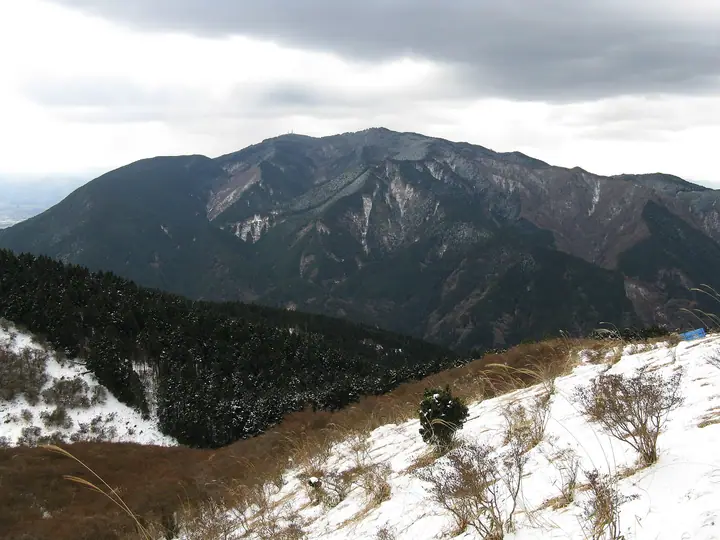
The highest point, Katsuragidake, is sacred ground behind Katsuragi Shrine and normally closed to entry; hikers use the Kunimi Castle ruins plaza as the summit. Katsuragi Shrine and Tenporinji Temple, traditionally founded by En no Gyoja, stand near the top. Routes include Chihaya Hondo, Fushimimichi and Yubinmichi. Winter draws hikers to its snow and rime ice.
Mount Kongo at a glance
- Weather: The most settled day in the next 7 days is Thu, November 5: clear, gusts up to 4 m/s.
- Route: The shortest is Mount Kongo Loop via Teradani and Monju Ridge from Hyakugatsuji: about 2 h 40 min, 4.4 km, about 470 m of climbing.
Mount Kongo weather (hourly, 14 days)
Sunrise today 06:19, sunset 17:03
| Tue, 11/3 | Wed, 11/4 | Thu, 11/5 | Fri, 11/6 | Sat, 11/7 | Sun, 11/8 | Mon, 11/9 | Tue, 11/10 | Wed, 11/11 | Thu, 11/12 | Fri, 11/13 | Sat, 11/14 | Sun, 11/15 | Mon, 11/16 | Tue, 11/17 | |||||||||||||||||||||||||||||||||||||||||||||||||||||||||||||||||||||||
|---|---|---|---|---|---|---|---|---|---|---|---|---|---|---|---|---|---|---|---|---|---|---|---|---|---|---|---|---|---|---|---|---|---|---|---|---|---|---|---|---|---|---|---|---|---|---|---|---|---|---|---|---|---|---|---|---|---|---|---|---|---|---|---|---|---|---|---|---|---|---|---|---|---|---|---|---|---|---|---|---|---|---|---|---|---|
| Japan time | 21 | 23 | 1 | 3 | 5 | 7 | 9 | 11 | 13 | 15 | 17 | 19 | 21 | 0 | 3 | 6 | 9 | 12 | 15 | 18 | 21 | 0 | 3 | 6 | 9 | 12 | 15 | 18 | 21 | 0 | 3 | 6 | 9 | 12 | 15 | 18 | 21 | 0 | 3 | 6 | 9 | 12 | 15 | 18 | 21 | 0 | 3 | 6 | 9 | 12 | 15 | 21 | 3 | 9 | 15 | 21 | 3 | 9 | 15 | 21 | 3 | 9 | 15 | 21 | 3 | 9 | 15 | 21 | 3 | 9 | 15 | 21 | 3 | 9 | 15 | 21 | 3 | 9 | 15 | 21 | 3 | 9 | 15 | 21 | |
  |   |  | | |   | |   | | |   | | |   | |   |   |   | |   |   | | | | | |  |  | | | | | | | | | | | | | | | | | | | | | | | | |   | | | | | | | |  | | | | | | | | | | | | | |   | | | | | |  | | | | ||
| Temperature | °C | 8° | 7° | 6° | 5° | 5° | 6° | 10° | 11° | 12° | 13° | 11° | 11° | 10° | 9° | 9° | 9° | 11° | 14° | 16° | 13° | 11° | 10° | 12° | 10° | 12° | 14° | 14° | 11° | 8° | 7° | 5° | 4° | 8° | 9° | 9° | 5° | 3° | 2° | 1° | 2° | 5° | 8° | 9° | 6° | 6° | 5° | 4° | 4° | 7° | 10° | 11° | 6° | 2° | 9° | 11° | 6° | 4° | 6° | 8° | 3° | 0° | 6° | 9° | 2° | 3° | 7° | 9° | 3° | -1° | 6° | 11° | 4° | 2° | 10° | 14° | 9° | 8° | 11° | 12° | 6° | 2° | 5° | 9° | 3° |
| Precipitation | mm | 0.8 | 0.2 | 0.4 | 0.2 | 1.4 | 1.5 | 7 | 7 | 0.7 | 1.1 | 0.6 | 0.1 | 0.2 | 0.2 | 0.2 | 0.2 | 1.8 | 25 | 0.5 | 1.3 | 0.2 | |||||||||||||||||||||||||||||||||||||||||||||||||||||||||||||||
| New snow | cm | ||||||||||||||||||||||||||||||||||||||||||||||||||||||||||||||||||||||||||||||||||||
| Snow depth | cm | 0 | 0 | 0 | 0 | 0 | 0 | 0 | 0 | 0 | 0 | 0 | 0 | 0 | 0 | 0 | 0 | 0 | 0 | 0 | 0 | 0 | 0 | 0 | 0 | 0 | 0 | 0 | 0 | 0 | 0 | 0 | 0 | 0 | 0 | 0 | 0 | 0 | 0 | 0 | 0 | 0 | 0 | 0 | 0 | 0 | 0 | 0 | 0 | 0 | 0 | 0 | 0 | 0 | 0 | 0 | 0 | 0 | 0 | 0 | 0 | 0 | 0 | 0 | 0 | 0 | 0 | 0 | 0 | 0 | 0 | 0 | 0 | 0 | 0 | 0 | 0 | 0 | 0 | 0 | 0 | 0 | 0 | 0 | 0 |
| Wind | m/s | 0 | 0 | 0 | 0 | 1 | 1 | 1 | 1 | 2 | 2 | 2 | 2 | 2 | 1 | 1 | 1 | 0 | 0 | 1 | 1 | 0 | 1 | 3 | 1 | 4 | 5 | 5 | 2 | 2 | 2 | 2 | 1 | 3 | 4 | 5 | 2 | 1 | 1 | 1 | 0 | 1 | 3 | 2 | 1 | 0 | 0 | 1 | 1 | 1 | 1 | 1 | 0 | 1 | 2 | 3 | 2 | 4 | 4 | 5 | 1 | 1 | 1 | 1 | 1 | 2 | 2 | 4 | 1 | 1 | 0 | 1 | 1 | 1 | 1 | 1 | 0 | 1 | 2 | 4 | 2 | 1 | 1 | 1 | 1 |
| Wind gusts | m/s | 4 | 2 | 2 | 3 | 3 | 3 | 5 | 6 | 6 | 6 | 6 | 6 | 6 | 6 | 4 | 3 | 3 | 3 | 4 | 3 | 6 | 7 | 9 | 9 | 10 | 12 | 14 | 13 | 8 | 8 | 7 | 6 | 9 | 11 | 12 | 12 | 8 | 4 | 4 | 4 | 4 | 8 | 8 | 5 | 3 | 2 | 2 | 3 | 3 | 6 | 5 | 6 | 3 | 6 | 9 | 8 | 11 | 11 | 14 | 12 | 4 | 3 | 6 | 4 | 6 | 7 | 11 | 10 | 3 | 4 | 4 | 3 | 4 | 5 | 6 | 6 | 8 | 8 | 12 | 11 | 7 | 4 | 7 | 4 |
| Wind dir. | ↓ | ↓ | ↓ | ↓ | ↓ | ↓ | ↓ | ↓ | ↓ | ↓ | ↓ | ↓ | ↓ | ↓ | ↓ | ↓ | ↓ | ↓ | ↓ | ↓ | ↓ | ↓ | ↓ | ↓ | ↓ | ↓ | ↓ | ↓ | ↓ | ↓ | ↓ | ↓ | ↓ | ↓ | ↓ | ↓ | ↓ | ↓ | ↓ | ↓ | ↓ | ↓ | ↓ | ↓ | ↓ | ↓ | ↓ | ↓ | ↓ | ↓ | ↓ | ↓ | ↓ | ↓ | ↓ | ↓ | ↓ | ↓ | ↓ | ↓ | ↓ | ↓ | ↓ | ↓ | ↓ | ↓ | ↓ | ↓ | ↓ | ↓ | ↓ | ↓ | ↓ | ↓ | ↓ | ↓ | ↓ | ↓ | ↓ | ↓ | ↓ | ↓ | ↓ | ↓ | |
Mount Kongo live cameras
Mount Kongo hiking routes
- Mount Kongo Loop via Teradani and Monju Ridge from Hyakugatsuji 4.4 km · Ascent 472 m 百ヶ辻, Chihaya Ropeway mae (Mt Kongo Ropeway) (Bus station), Ropeway mae (Station) (Bus station), Kongosan Ropeway mae (Mt Kongo Ropeway) (Bus stop)
- Kongōsan via Teratani and Chihaya Hondō 4.8 km · Ascent 472 m 百ヶ辻, Chihaya Ropeway mae (Mt Kongo Ropeway) (Bus station), Ropeway mae (Station) (Bus station), Kongosan Ropeway mae (Mt Kongo Ropeway) (Bus stop) → parking
- Mount Kongo Loop via Kurotogadani and Chihaya Hondo 5.5 km · Ascent 570 m Kongo Tozanguchi (Trailhead) (Bus stop) (parking)
- Mount Kongō Circuit via Chihaya Main Trail and Takahata Valley 5.7 km · Ascent 574 m Kongo Tozanguchi (Trailhead) (Bus stop) (parking)
- Mount Kongo via Chihaya Main Trail 6.1 km · Ascent 592 m Kongo Tozanguchi (Trailhead) (Bus stop) (parking)
- Mount Kongo Wildflower Trail 6.7 km · Ascent 614 m Kongo Tozanguchi (Trailhead) (Bus stop) (parking) → Chihaya Ropeway mae (Mt Kongo Ropeway) (Bus station), Ropeway mae (Station) (Bus station), Kongosan Ropeway mae (Mt Kongo Ropeway) (Bus stop) (parking)
- Mount Kongo Round Trip via Fushimi Pass and Chihaya-enchi from Mogatsuji 8.1 km · Ascent 538 m 百ヶ辻, Chihaya Ropeway mae (Mt Kongo Ropeway) (Bus station), Ropeway mae (Station) (Bus station), Kongosan Ropeway mae (Mt Kongo Ropeway) (Bus stop)
- Momiji Valley, Mount Kongō and Mount Dainichi Circuit from Mizukoshi Pass 8.6 km · Ascent 635 m Mizukoshitoge Pass (Bus) (Bus stop), 水越無料駐車場 (parking)
- Kongōsan via Momijidani and the Taiō Ridge 8.2 km · Ascent 693 m 水越無料駐車場, Mizukoshitoge Pass (Bus) (Bus stop) (parking)
- Mount Kongo Loop from Mizukoshi Pass up Momiji Valley and down via Dainichidake 9.9 km · Ascent 668 m Mizukoshitoge Pass (Bus) (Bus stop), 水越無料駐車場 (parking)
- Mount Kongō Return from Takamahiko Shrine 7.4 km · Ascent 726 m parking
- Mount Kongo Return via Taobi East Ridge and Mount Dainichi 7.1 km · Ascent 699 m 水越無料駐車場, Mizukoshitoge Pass (Bus) (Bus stop) (parking)
- Mount Dainichi and Mount Kongō Circuit from Mizukoshi Pass 9.9 km · Ascent 683 m Mizukoshitoge Pass (Bus) (Bus stop), 水越無料駐車場 (parking)
- Mount Kongō and Katsuragi Shrine Loop from Mizukoshi Pass 10.6 km · Ascent 693 m 水越無料駐車場, Mizukoshitoge Pass (Bus) (Bus stop) (parking)
- Mount Kongo Circuit via Taio Ridge and Aogedori Trail 8.9 km · Ascent 809 m Katsuragi trailhead (Bus) (Bus stop)
- Mount Kongo Loop from Mizukoshi Pass, up the Aokuzure Trail and down the Diamond Trail 11.0 km · Ascent 781 m 水越無料駐車場, Mizukoshitoge Pass (Bus) (Bus stop) (parking)
- Mount Kongo and Yushutsudake via Amagataki Trail 9.5 km · Ascent 779 m
- Kongo Range Loop from the Azalea Highland of Katsuragi by Mizukoshi Pass to Kongo's Summit Shrine 16.0 km · Ascent 1,281 m Katsuragi trailhead (Bus) (Bus stop)
- Diamond Trail: Amami Station to Mount Kongo Return 32.4 km · Ascent 1,960 m 天見駅 (Station), Amami (Station) (parking)
Hiking times are estimates calculated from the terrain.
Huts, campsites and lodging near Mount Kongo
Mountain huts
- Konan-sou (CLOSED)
Campsites
- Chihayaenchi Kongosan Campground
- 葛城高原キャンプ場
Mount Kongo facts
- Elevation
- 1,125 m
- Location
- Gose, Nara
34.419430, 135.672934 - Website
- www.vill.chihayaakasaka.osaka.jp
- Trail Map
- www.city.gose.nara.jp
- Access Information
- osaka-info.jp
- Wikipedia
- ja.wikipedia.org