
Mount Nijō
二上山
Katsuragi, Nara / Taishi, Osaka · Elevation 517 m
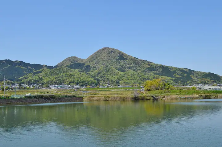
Mount Nijō (Odake, 517 m) is a twin-peak ridge straddling Taishi Town in Osaka and Katsuragi / Kashiba in Nara Prefecture, consisting of the northern Odake (517 m) and the southern Medake (474 m). Within Kongō-Ikoma-Kisen Quasi-National Park, it forms the northern terminus of the Diamond Trail long-distance footpath. The summit of Odake is traditionally the burial site of Prince Ōtsu, and the mountain — called Futakami-yama in the Manyōshū — has been a sacred landmark since antiquity, with Taima-dera at its foot. The peak is listed in the Hundred Flowering Mountains and the Kansai 100.
Mount Nijō at a glance
- Weather: The most settled day in the next 7 days is Thu, November 5: cloudy, gusts up to 4 m/s.
- Route: The shortest is Mount Nijō Medake and Iwaya Pass Loop from Manyō-no-Mori: about 1 h 20 min, 2.4 km, about 250 m of climbing.
Mount Nijō weather (hourly, 14 days)
Sunrise today 06:19, sunset 17:03
| Tue, 11/3 | Wed, 11/4 | Thu, 11/5 | Fri, 11/6 | Sat, 11/7 | Sun, 11/8 | Mon, 11/9 | Tue, 11/10 | Wed, 11/11 | Thu, 11/12 | Fri, 11/13 | Sat, 11/14 | Sun, 11/15 | Mon, 11/16 | Tue, 11/17 | |||||||||||||||||||||||||||||||||||||||||||||||||||||||||||||||||||||||
|---|---|---|---|---|---|---|---|---|---|---|---|---|---|---|---|---|---|---|---|---|---|---|---|---|---|---|---|---|---|---|---|---|---|---|---|---|---|---|---|---|---|---|---|---|---|---|---|---|---|---|---|---|---|---|---|---|---|---|---|---|---|---|---|---|---|---|---|---|---|---|---|---|---|---|---|---|---|---|---|---|---|---|---|---|---|
| Japan time | 15 | 17 | 19 | 21 | 23 | 1 | 3 | 5 | 7 | 9 | 11 | 13 | 15 | 18 | 21 | 0 | 3 | 6 | 9 | 12 | 15 | 18 | 21 | 0 | 3 | 6 | 9 | 12 | 15 | 18 | 21 | 0 | 3 | 6 | 9 | 12 | 15 | 18 | 21 | 0 | 3 | 6 | 9 | 12 | 15 | 18 | 21 | 0 | 3 | 6 | 9 | 15 | 21 | 3 | 9 | 15 | 21 | 3 | 9 | 15 | 21 | 3 | 9 | 15 | 21 | 3 | 9 | 15 | 21 | 3 | 9 | 15 | 21 | 3 | 9 | 15 | 21 | 3 | 9 | 15 | 21 | 3 | 9 | 15 | |
  | |   | | | | | | |   | | |   |   |   |   | | |   | | | | |   | | | |   | | |  | | | |  | | | | | | | | | | | | | | | | | |   | | | | | | | |   |  | | | | | | | | | | | | | | | | | | | |  | | | ||
| Temperature | °C | 16° | 14° | 11° | 11° | 10° | 9° | 7° | 6° | 7° | 11° | 13° | 16° | 16° | 14° | 13° | 12° | 12° | 12° | 14° | 15° | 18° | 15° | 14° | 13° | 14° | 13° | 15° | 17° | 17° | 14° | 11° | 9° | 8° | 7° | 10° | 12° | 11° | 8° | 6° | 5° | 3° | 3° | 9° | 11° | 12° | 9° | 9° | 8° | 7° | 7° | 11° | 13° | 9° | 5° | 11° | 14° | 9° | 7° | 8° | 10° | 6° | 3° | 8° | 11° | 5° | 6° | 9° | 11° | 6° | 2° | 7° | 13° | 7° | 5° | 11° | 16° | 11° | 11° | 14° | 15° | 9° | 5° | 7° | 12° |
| Precipitation | mm | 7 | 1.9 | 0.5 | 0.1 | 0.5 | 11 | 0.3 | 0.1 | 0.2 | 0.3 | 0.2 | 2.3 | 17 | 0.3 | 1.0 | |||||||||||||||||||||||||||||||||||||||||||||||||||||||||||||||||||||
| New snow | cm | ||||||||||||||||||||||||||||||||||||||||||||||||||||||||||||||||||||||||||||||||||||
| Snow depth | cm | 0 | 0 | 0 | 0 | 0 | 0 | 0 | 0 | 0 | 0 | 0 | 0 | 0 | 0 | 0 | 0 | 0 | 0 | 0 | 0 | 0 | 0 | 0 | 0 | 0 | 0 | 0 | 0 | 0 | 0 | 0 | 0 | 0 | 0 | 0 | 0 | 0 | 0 | 0 | 0 | 0 | 0 | 0 | 0 | 0 | 0 | 0 | 0 | 0 | 0 | 0 | 0 | 0 | 0 | 0 | 0 | 0 | 0 | 0 | 0 | 0 | 0 | 0 | 0 | 0 | 0 | 0 | 0 | 0 | 0 | 0 | 0 | 0 | 0 | 0 | 0 | 0 | 0 | 0 | 0 | 0 | 0 | 0 | 0 |
| Wind | m/s | 2 | 2 | 1 | 1 | 0 | 0 | 1 | 1 | 1 | 0 | 2 | 3 | 3 | 4 | 4 | 3 | 2 | 1 | 1 | 1 | 1 | 0 | 1 | 1 | 4 | 2 | 3 | 4 | 4 | 3 | 2 | 2 | 2 | 2 | 3 | 4 | 4 | 3 | 1 | 1 | 1 | 1 | 1 | 2 | 2 | 1 | 0 | 0 | 0 | 1 | 0 | 2 | 0 | 1 | 1 | 4 | 2 | 4 | 3 | 5 | 1 | 1 | 1 | 2 | 2 | 1 | 1 | 4 | 1 | 1 | 0 | 2 | 1 | 2 | 1 | 1 | 1 | 2 | 2 | 4 | 2 | 2 | 1 | 1 |
| Wind gusts | m/s | 6 | 6 | 4 | 3 | 1 | 1 | 1 | 2 | 2 | 3 | 5 | 7 | 7 | 8 | 9 | 8 | 7 | 4 | 3 | 3 | 4 | 4 | 3 | 4 | 9 | 9 | 8 | 10 | 11 | 11 | 7 | 5 | 5 | 4 | 9 | 11 | 11 | 10 | 6 | 2 | 2 | 3 | 3 | 6 | 6 | 6 | 2 | 1 | 2 | 3 | 3 | 6 | 5 | 2 | 4 | 10 | 9 | 9 | 9 | 13 | 12 | 3 | 4 | 6 | 5 | 5 | 4 | 11 | 9 | 3 | 4 | 5 | 4 | 4 | 5 | 5 | 4 | 7 | 7 | 12 | 12 | 5 | 4 | 5 |
| Wind dir. | ↓ | ↓ | ↓ | ↓ | ↓ | ↓ | ↓ | ↓ | ↓ | ↓ | ↓ | ↓ | ↓ | ↓ | ↓ | ↓ | ↓ | ↓ | ↓ | ↓ | ↓ | ↓ | ↓ | ↓ | ↓ | ↓ | ↓ | ↓ | ↓ | ↓ | ↓ | ↓ | ↓ | ↓ | ↓ | ↓ | ↓ | ↓ | ↓ | ↓ | ↓ | ↓ | ↓ | ↓ | ↓ | ↓ | ↓ | ↓ | ↓ | ↓ | ↓ | ↓ | ↓ | ↓ | ↓ | ↓ | ↓ | ↓ | ↓ | ↓ | ↓ | ↓ | ↓ | ↓ | ↓ | ↓ | ↓ | ↓ | ↓ | ↓ | ↓ | ↓ | ↓ | ↓ | ↓ | ↓ | ↓ | ↓ | ↓ | ↓ | ↓ | ↓ | ↓ | ||
Mount Nijō hiking routes
- Mount Nijō Medake and Iwaya Pass Loop from Manyō-no-Mori 2.4 km · Ascent 251 m parking
- Mount Nijō Twin-Summit Hike from Manyō-no-Mori 3.8 km · Ascent 337 m parking
- Katsuragi Loop from Taima via Yusenji to Mount Nijo's Female Peak and Back via Iwaya Pass 4.7 km · Ascent 367 m parking
- Mount Nijo Odake–Medake–Iwaya Pass Circuit 7.2 km · Ascent 479 m Nijō-Jinjaguchi (Station)
Hiking times are estimates calculated from the terrain.
Huts, campsites and lodging near Mount Nijō
Lodging
- かつらぎの森
Lists that include Mount Nijō
100 Famous Mountains of Flowers · 100 Low Mountains of Japan · Illustrated Collection of Japan's Famous Mountains · Kansai 100 Famous Mountains · Kinki 100 Famous Mountains · Osaka 50 Mountains · Nara 100 Mountains to Explore · Diamond Trail · Elevations of 1003 Mountains of Japan · 1000 Mountains of Japan
Mount Nijō facts
- Also known as
- 雄岳 · ふたかみやま
- Elevation
- 517 m
- Location
- Katsuragi, Nara / Taishi, Osaka
34.525731, 135.677526 - National Park
- 金剛生駒紀泉国定公園
- Website
- www.city.katsuragi.nara.jp
- Trail Map
- www.town.taishi.osaka.jp (PDF)
- Wikipedia
- ja.wikipedia.org