
Mt. Amidadake
阿弥陀岳
Hara, Nagano · Elevation 2,805 m
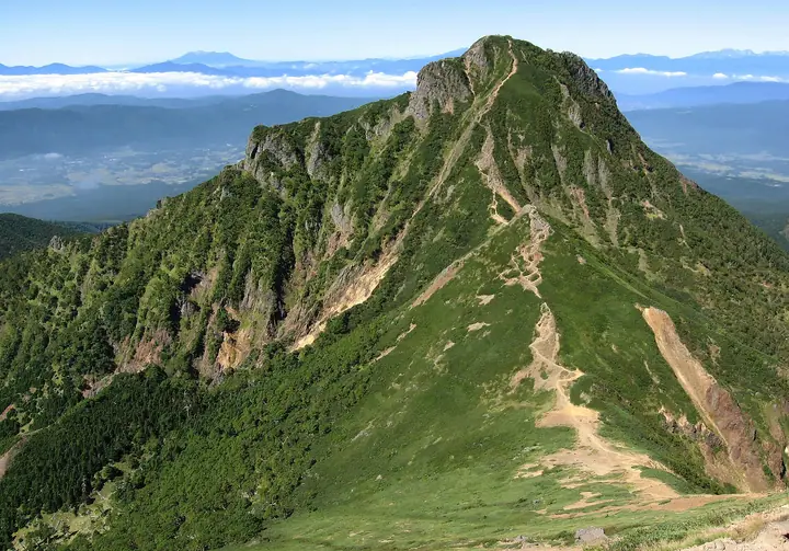
Mt. Amidadake is a 2,805 m peak straddling Hara Village and Chino City in Suwa District of Nagano Prefecture, the third-highest summit of the Yatsugatake Range, lying about 1 km west of the main peak Mt. Akadake. Its summit hosts a statue of Amida Nyorai and stone monuments left by mountain-worship groups, and an annual kaizan-sai (mountain-opening rite) is held in early June along the Funayama-jūjiro route. Within Yatsugatake-Chūshin-Kōgen Quasi-National Park, the peak appears in Nihon Hyaku-Kōzan, Nihon 2500-Meter Peaks, Shinshū Furusato 120-zan, and Shirahata Shirō's Hyaku-ichi Meizan.
Mt. Amidadake at a glance
- Weather: The most settled day in the next 7 days is Sun, November 8: clear, gusts up to 8 m/s. Fri, Nov 6, Sat, Nov 7: strong wind (gusts up to 18 m/s).
- Route: The shortest is Mount Amidadake Out-and-Back via Okoya Ridge and Mount Okoya from Funayama Crossroads: about 6 h 56 min, 11.4 km, about 1,240 m of climbing.
Mt. Amidadake weather (hourly, 14 days)
Sunrise today 06:10, sunset 16:50
| Tue, 11/3 | Wed, 11/4 | Thu, 11/5 | Fri, 11/6 | Sat, 11/7 | Sun, 11/8 | Mon, 11/9 | Tue, 11/10 | Wed, 11/11 | Thu, 11/12 | Fri, 11/13 | Sat, 11/14 | Sun, 11/15 | Mon, 11/16 | Tue, 11/17 | |||||||||||||||||||||||||||||||||||||||||||||||||||||||||||||||||||||||
|---|---|---|---|---|---|---|---|---|---|---|---|---|---|---|---|---|---|---|---|---|---|---|---|---|---|---|---|---|---|---|---|---|---|---|---|---|---|---|---|---|---|---|---|---|---|---|---|---|---|---|---|---|---|---|---|---|---|---|---|---|---|---|---|---|---|---|---|---|---|---|---|---|---|---|---|---|---|---|---|---|---|---|---|---|---|
| Japan time | 21 | 23 | 1 | 3 | 5 | 7 | 9 | 11 | 13 | 15 | 17 | 19 | 21 | 0 | 3 | 6 | 9 | 12 | 15 | 18 | 21 | 0 | 3 | 6 | 9 | 12 | 15 | 18 | 21 | 0 | 3 | 6 | 9 | 12 | 15 | 18 | 21 | 0 | 3 | 6 | 9 | 12 | 15 | 18 | 21 | 0 | 3 | 6 | 9 | 12 | 15 | 21 | 3 | 9 | 15 | 21 | 3 | 9 | 15 | 21 | 3 | 9 | 15 | 21 | 3 | 9 | 15 | 21 | 3 | 9 | 15 | 21 | 3 | 9 | 15 | 21 | 3 | 9 | 15 | 21 | 3 | 9 | 15 | 21 | |
  | | | | |   | | |   |   |   | |   | | |   |   | | |   | | |   | |  | | |  | | | | | | | | | | | | | | | | | | | | |   |   | | | | | | |   |   | | |  | | | | | | | | | | | | | | | | | | | | | | | | ||
| Temperature | °C | -3° | -4° | -3° | -4° | -4° | -4° | 3° | 5° | 5° | 3° | 0° | 0° | 0° | 0° | 0° | 0° | 5° | 10° | 8° | 3° | 2° | 1° | 1° | 1° | 5° | 8° | 7° | 1° | -1° | -5° | -7° | -8° | -2° | 0° | -1° | -6° | -8° | -8° | -8° | -9° | -1° | 4° | 4° | -2° | -3° | -3° | -3° | -2° | 0° | 6° | 6° | -2° | -3° | 1° | 3° | -3° | -5° | -4° | -2° | -8° | -10° | -1° | 2° | -6° | -7° | -1° | 1° | -8° | -8° | 0° | 4° | -5° | -6° | 1° | 4° | 0° | 0° | 5° | 6° | -3° | -7° | -1° | 2° | -2° |
| Precipitation | mm | 1.0 | 6 | 7 | 3.9 | 0.6 | 0.6 | 1.6 | 0.3 | 0.5 | 0.1 | 0.1 | 0.2 | 8 | 11 | 0.3 | 0.2 | ||||||||||||||||||||||||||||||||||||||||||||||||||||||||||||||||||||
| New snow | cm | <.1 | 0.2 | ||||||||||||||||||||||||||||||||||||||||||||||||||||||||||||||||||||||||||||||||||
| Snow depth | cm | 0 | 0 | 0 | 0 | 0 | 0 | 0 | 0 | 0 | 0 | 0 | 0 | 0 | 0 | 0 | 0 | 0 | 0 | 0 | 0 | 0 | 0 | 0 | 0 | 0 | 0 | 0 | 0 | 0 | 0 | 0 | 0 | 0 | 0 | 0 | 0 | 0 | 0 | 0 | 0 | 0 | 0 | 0 | 0 | 0 | 0 | 0 | 0 | 0 | 0 | 0 | 0 | 0 | 0 | 0 | 0 | 0 | 0 | 0 | 0 | 0 | 0 | 0 | 0 | 0 | 0 | 0 | 0 | 0 | 0 | 0 | 0 | 0 | 0 | 0 | 0 | 0 | 0 | 0 | 0 | 0 | 0 | 0 | 0 |
| Wind | m/s | 1 | 1 | 1 | 1 | 1 | 1 | 1 | 2 | 2 | 2 | 2 | 2 | 2 | 2 | 1 | 1 | 2 | 2 | 1 | 1 | 0 | 1 | 1 | 2 | 3 | 4 | 4 | 2 | 2 | 2 | 2 | 2 | 3 | 4 | 4 | 2 | 2 | 2 | 2 | 2 | 1 | 2 | 1 | 0 | 1 | 0 | 1 | 1 | 1 | 3 | 3 | 2 | 2 | 2 | 4 | 2 | 3 | 5 | 3 | 1 | 2 | 2 | 3 | 1 | 2 | 2 | 2 | 1 | 2 | 2 | 2 | 1 | 1 | 1 | 1 | 1 | 1 | 2 | 4 | 2 | 2 | 1 | 2 | 1 |
| Wind gusts | m/s | 5 | 5 | 5 | 5 | 5 | 4 | 5 | 8 | 9 | 9 | 8 | 9 | 11 | 11 | 10 | 7 | 7 | 8 | 8 | 7 | 6 | 9 | 10 | 11 | 13 | 16 | 16 | 15 | 11 | 12 | 12 | 13 | 16 | 18 | 18 | 15 | 11 | 10 | 9 | 9 | 7 | 8 | 8 | 6 | 7 | 8 | 8 | 8 | 9 | 12 | 12 | 8 | 6 | 8 | 14 | 13 | 16 | 22 | 21 | 14 | 7 | 8 | 12 | 10 | 10 | 11 | 12 | 10 | 8 | 7 | 8 | 6 | 7 | 7 | 10 | 9 | 12 | 11 | 16 | 15 | 9 | 6 | 7 | 7 |
| Wind dir. | ↓ | ↓ | ↓ | ↓ | ↓ | ↓ | ↓ | ↓ | ↓ | ↓ | ↓ | ↓ | ↓ | ↓ | ↓ | ↓ | ↓ | ↓ | ↓ | ↓ | ↓ | ↓ | ↓ | ↓ | ↓ | ↓ | ↓ | ↓ | ↓ | ↓ | ↓ | ↓ | ↓ | ↓ | ↓ | ↓ | ↓ | ↓ | ↓ | ↓ | ↓ | ↓ | ↓ | ↓ | ↓ | ↓ | ↓ | ↓ | ↓ | ↓ | ↓ | ↓ | ↓ | ↓ | ↓ | ↓ | ↓ | ↓ | ↓ | ↓ | ↓ | ↓ | ↓ | ↓ | ↓ | ↓ | ↓ | ↓ | ↓ | ↓ | ↓ | ↓ | ↓ | ↓ | ↓ | ↓ | ↓ | ↓ | ↓ | ↓ | ↓ | ↓ | ↓ | ↓ | |
Mt. Amidadake hiking routes
- Mount Amidadake Out-and-Back via Okoya Ridge and Mount Okoya from Funayama Crossroads 11.4 km · Ascent 1,239 m parking
- Mount Akadake and Amidadake Loop via Jizo Ridge 18.5 km · Ascent 1,648 m 美濃戸口 (Bus stop) (parking)
- Southern Yatsugatake Main-Ridge Circuit 20.7 km · Ascent 1,934 m 美濃戸口 (Bus stop) (parking)
Hiking times are estimates calculated from the terrain.
Huts, campsites and lodging near Mt. Amidadake
Mountain huts
- Gyoja Goya 2026: open May 30–October 31 · reservation required · sleeps 80
- 赤岳頂上山荘 2026: open June 19–October 25 · reservation required · sleeps 100
- Kiretto Hut temporarily closed
- 赤岳展望荘 2026: open April 24–November 3 · reservation required · sleeps 138
- Akadake Kosen 2026: open all year · reservation required
Campsites
- 行者小屋テント場
- 赤岳鉱泉テント場
- 青年小屋テントサイト
- 夏沢だけかんばキャンプ場
- 本沢温泉テント場
Lists that include Mt. Amidadake
Japan's 100 Highest Mountains · Shinshu Mountain Cards · Elevations of 1003 Mountains of Japan · 1000 Mountains of Japan
Mt. Amidadake facts
- Elevation
- 2,805 m
- Location
- Hara, Nagano
35.972397, 138.358753 - National Park
- 八ヶ岳中信高原国定公園
- Website
- www.vill.hara.lg.jp
- Trail Map
- www.vill.hara.lg.jp (PDF)
- Wikipedia
- ja.wikipedia.org