
Akaiwa-no-Atama
赤岩ノ頭
Chino, Nagano · Elevation 2,656 m
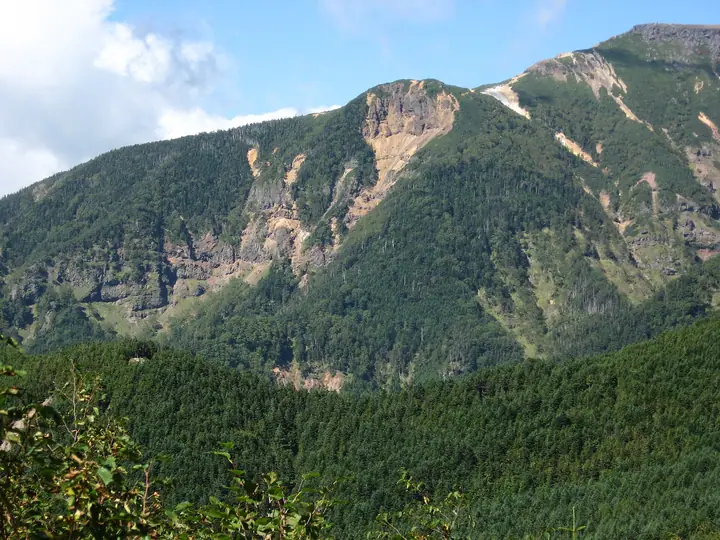
Akaiwa-no-Atama (2,656 m) lies in Chino City, Nagano Prefecture, on the ridge that extends about 660 m west from Mount Iō in the southern Yatsugatake, within the Yatsugatake-Chūshin-Kōgen Quasi-National Park. The point is where the trail up from Akadake-Kōsen mountain hut meets the ridge en route to Mount Iō, and although the summit itself bears little signage, it is a quiet vantage with sweeping views over Mount Aka, Mount Yoko, and Mount Iō.
Akaiwa-no-Atama at a glance
- Weather: The most settled day in the next 7 days is Sun, November 8: clear, gusts up to 8 m/s. Fri, Nov 6, Sat, Nov 7: strong wind (gusts up to 18 m/s).
- Route: The shortest is Mount Iodake and Akaiwa-no-Atama Loop from Sakuradaira: about 6 h 25 min, 10.7 km, about 940 m of climbing.
Akaiwa-no-Atama weather (hourly, 14 days)
Sunrise today 06:10, sunset 16:50
| Tue, 11/3 | Wed, 11/4 | Thu, 11/5 | Fri, 11/6 | Sat, 11/7 | Sun, 11/8 | Mon, 11/9 | Tue, 11/10 | Wed, 11/11 | Thu, 11/12 | Fri, 11/13 | Sat, 11/14 | Sun, 11/15 | Mon, 11/16 | Tue, 11/17 | |||||||||||||||||||||||||||||||||||||||||||||||||||||||||||||||||||||||
|---|---|---|---|---|---|---|---|---|---|---|---|---|---|---|---|---|---|---|---|---|---|---|---|---|---|---|---|---|---|---|---|---|---|---|---|---|---|---|---|---|---|---|---|---|---|---|---|---|---|---|---|---|---|---|---|---|---|---|---|---|---|---|---|---|---|---|---|---|---|---|---|---|---|---|---|---|---|---|---|---|---|---|---|---|---|
| Japan time | 15 | 17 | 19 | 21 | 23 | 1 | 3 | 5 | 7 | 9 | 11 | 13 | 15 | 18 | 21 | 0 | 3 | 6 | 9 | 12 | 15 | 18 | 21 | 0 | 3 | 6 | 9 | 12 | 15 | 18 | 21 | 0 | 3 | 6 | 9 | 12 | 15 | 18 | 21 | 0 | 3 | 6 | 9 | 12 | 15 | 18 | 21 | 0 | 3 | 6 | 9 | 15 | 21 | 3 | 9 | 15 | 21 | 3 | 9 | 15 | 21 | 3 | 9 | 15 | 21 | 3 | 9 | 15 | 21 | 3 | 9 | 15 | 21 | 3 | 9 | 15 | 21 | 3 | 9 | 15 | 21 | 3 | 9 | 15 | |
 |   | | | | | | |   | | | |   |   | | | |   |   |   |   | | |  |   |   | | | | | | | | | | | | | | | | | | | | | | | | | |   | | | | | |   |   | | |  | | | | | | | | | | | | | | | | | | | |   | | | ||
| Temperature | °C | 7° | 2° | 0° | -1° | -2° | -2° | -2° | -3° | -3° | 3° | 6° | 6° | 4° | 1° | 1° | 1° | 2° | 1° | 5° | 9° | 6° | 4° | 3° | 2° | 2° | 2° | 6° | 10° | 9° | 3° | -1° | -3° | -6° | -7° | -1° | 1° | 0° | -5° | -6° | -6° | -7° | -7° | 1° | 6° | 5° | -1° | -1° | -3° | -2° | -2° | 2° | 5° | -1° | -2° | 1° | 3° | -2° | -4° | -3° | -1° | -7° | -9° | 0° | 3° | -5° | -6° | 0° | 2° | -7° | -7° | 1° | 5° | -4° | -5° | 2° | 4° | 1° | 1° | 6° | 7° | -2° | -6° | 0° | 3° |
| Precipitation | mm | 0.1 | 0.1 | 2.9 | 9 | 4.5 | 0.1 | 0.1 | 1.2 | 0.1 | 0.1 | 0.2 | 8 | 11 | 0.3 | 0.2 | |||||||||||||||||||||||||||||||||||||||||||||||||||||||||||||||||||||
| New snow | cm | <.1 | 0.2 | ||||||||||||||||||||||||||||||||||||||||||||||||||||||||||||||||||||||||||||||||||
| Snow depth | cm | 0 | 0 | 0 | 0 | 0 | 0 | 0 | 0 | 0 | 0 | 0 | 0 | 0 | 0 | 0 | 0 | 0 | 0 | 0 | 0 | 0 | 0 | 0 | 0 | 0 | 0 | 0 | 0 | 0 | 0 | 0 | 0 | 0 | 0 | 0 | 0 | 0 | 0 | 0 | 0 | 0 | 0 | 0 | 0 | 0 | 0 | 0 | 0 | 0 | 0 | 0 | 0 | 0 | 0 | 0 | 0 | 0 | 0 | 0 | 0 | 0 | 0 | 0 | 0 | 0 | 0 | 0 | 0 | 0 | 0 | 0 | 0 | 0 | 0 | 0 | 0 | 0 | 0 | 0 | 0 | 0 | 0 | 0 | 0 |
| Wind | m/s | 1 | 0 | 0 | 1 | 1 | 1 | 1 | 1 | 1 | 1 | 2 | 3 | 2 | 2 | 2 | 2 | 1 | 1 | 2 | 1 | 1 | 0 | 1 | 1 | 1 | 2 | 3 | 4 | 4 | 2 | 2 | 2 | 2 | 3 | 4 | 4 | 3 | 2 | 2 | 2 | 2 | 1 | 2 | 1 | 1 | 0 | 0 | 1 | 1 | 2 | 1 | 2 | 2 | 2 | 2 | 4 | 2 | 3 | 5 | 3 | 1 | 2 | 2 | 3 | 1 | 2 | 2 | 2 | 1 | 2 | 2 | 2 | 1 | 1 | 1 | 1 | 1 | 1 | 2 | 4 | 2 | 2 | 1 | 2 |
| Wind gusts | m/s | 8 | 5 | 4 | 5 | 5 | 5 | 5 | 5 | 4 | 6 | 8 | 9 | 9 | 9 | 10 | 11 | 11 | 9 | 7 | 7 | 9 | 8 | 6 | 8 | 9 | 10 | 12 | 15 | 16 | 14 | 12 | 11 | 12 | 14 | 17 | 18 | 17 | 14 | 10 | 9 | 9 | 9 | 8 | 7 | 8 | 6 | 6 | 7 | 7 | 8 | 8 | 13 | 8 | 6 | 8 | 14 | 13 | 16 | 22 | 21 | 14 | 7 | 8 | 12 | 10 | 10 | 11 | 12 | 10 | 8 | 7 | 8 | 6 | 7 | 7 | 10 | 9 | 12 | 11 | 16 | 15 | 9 | 6 | 7 |
| Wind dir. | ↓ | ↓ | ↓ | ↓ | ↓ | ↓ | ↓ | ↓ | ↓ | ↓ | ↓ | ↓ | ↓ | ↓ | ↓ | ↓ | ↓ | ↓ | ↓ | ↓ | ↓ | ↓ | ↓ | ↓ | ↓ | ↓ | ↓ | ↓ | ↓ | ↓ | ↓ | ↓ | ↓ | ↓ | ↓ | ↓ | ↓ | ↓ | ↓ | ↓ | ↓ | ↓ | ↓ | ↓ | ↓ | ↓ | ↓ | ↓ | ↓ | ↓ | ↓ | ↓ | ↓ | ↓ | ↓ | ↓ | ↓ | ↓ | ↓ | ↓ | ↓ | ↓ | ↓ | ↓ | ↓ | ↓ | ↓ | ↓ | ↓ | ↓ | ↓ | ↓ | ↓ | ↓ | ↓ | ↓ | ↓ | ↓ | ↓ | ↓ | ↓ | ↓ | ↓ | ↓ | |
Akaiwa-no-Atama hiking routes
- Mount Iodake and Akaiwa-no-Atama Loop from Sakuradaira 10.7 km · Ascent 944 m parking
- Mount Akadake, Yokodake and Iodake Circuit from Minotoguchi 21.5 km · Ascent 1,718 m 美濃戸口 (Bus stop) (parking)
- Southern Yatsugatake Main-Ridge Circuit 20.7 km · Ascent 1,934 m 美濃戸口 (Bus stop) (parking)
Hiking times are estimates calculated from the terrain.
Huts, campsites and lodging near Akaiwa-no-Atama
Mountain huts
- Iodake Sanso 2026: open April 25–November 5 · reservation required · sleeps 80
- Akadake Kosen 2026: open all year · reservation required
- Oren hut 2026: open April 25–November 1 · reservation required · sleeps 80
- Yamabikoso temporarily closed
- Hutte Natsuzawa 2026: open July 1–August 31 · reservation required
Campsites
- 赤岳鉱泉テント場
- 夏沢だけかんばキャンプ場
- 行者小屋テント場
- 本沢温泉テント場
- 黒百合ヒュッテ テント場
Lodging
- Karasawa Kousen
Akaiwa-no-Atama facts
- Elevation
- 2,656 m
- Location
- Chino, Nagano
35.995408, 138.363887 - National Park
- 八ヶ岳中信高原国定公園
- Website
- www.city.chino.lg.jp
- Access Information
- www.city.chino.lg.jp
- Wikipedia
- ja.wikipedia.org