
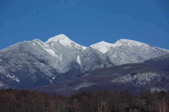
Mt. Higashitengudake
東天狗岳
Chino, Nagano · Elevation 2,645 m
The Tengudake peaks form the high point of the northern Yatsugatake range on the border of Chino and Koumi in Nagano. The summit splits into Higashi-Tengudake (about 2,640 m) and Nishi-Tengudake (2,646 m); the eastern peak rises sharply on the ridge and bears a rock tower called Tengu-iwa. Within the Yatsugatake-Chushin Kogen Quasi-National Park, it is a popular introductory climb reached from Shibunoyu via Kuroyuri-daira and the Kuroyuri Hut.
Mt. Higashitengudake at a glance
- Weather: The most settled day in the next 7 days is Wed, November 4: clear, gusts up to 7 m/s.
- Route: The shortest is West and East Tengudake Loop from Karasawa Onsen: about 5 h 34 min, 8.6 km, about 870 m of climbing.
Mt. Higashitengudake weather (hourly, 14 days)
Sunrise today 06:10, sunset 16:50
| Tue, 11/3 | Wed, 11/4 | Thu, 11/5 | Fri, 11/6 | Sat, 11/7 | Sun, 11/8 | Mon, 11/9 | Tue, 11/10 | Wed, 11/11 | Thu, 11/12 | Fri, 11/13 | Sat, 11/14 | Sun, 11/15 | Mon, 11/16 | Tue, 11/17 | |||||||||||||||||||||||||||||||||||||||||||||||||||||||||||||||||||||||
|---|---|---|---|---|---|---|---|---|---|---|---|---|---|---|---|---|---|---|---|---|---|---|---|---|---|---|---|---|---|---|---|---|---|---|---|---|---|---|---|---|---|---|---|---|---|---|---|---|---|---|---|---|---|---|---|---|---|---|---|---|---|---|---|---|---|---|---|---|---|---|---|---|---|---|---|---|---|---|---|---|---|---|---|---|---|
| Japan time | 15 | 17 | 19 | 21 | 23 | 1 | 3 | 5 | 7 | 9 | 11 | 13 | 15 | 18 | 21 | 0 | 3 | 6 | 9 | 12 | 15 | 18 | 21 | 0 | 3 | 6 | 9 | 12 | 15 | 18 | 21 | 0 | 3 | 6 | 9 | 12 | 15 | 18 | 21 | 0 | 3 | 6 | 9 | 12 | 15 | 18 | 21 | 0 | 3 | 6 | 9 | 15 | 21 | 3 | 9 | 15 | 21 | 3 | 9 | 15 | 21 | 3 | 9 | 15 | 21 | 3 | 9 | 15 | 21 | 3 | 9 | 15 | 21 | 3 | 9 | 15 | 21 | 3 | 9 | 15 | 21 | 3 | 9 | 15 | |
  |   |  | | | | | | | | | |   |   | |   | | |   |   |   |  | | |   | |  | | | | |   | | | | | | | | | | | | | | | | | | | | | | | | | |   |   | | |  | | | | | |   | | | | | | | | | | | |   | | | | | ||
| Temperature | °C | 5° | 0° | -1° | -2° | -3° | -2° | -2° | -3° | -2° | 3° | 6° | 7° | 5° | 1° | 1° | 1° | 2° | 1° | 5° | 8° | 7° | 4° | 3° | 2° | 2° | 3° | 7° | 9° | 8° | 2° | -2° | -4° | -6° | -7° | -2° | 1° | 0° | -6° | -7° | -6° | -6° | -6° | 1° | 5° | 3° | -3° | -3° | -3° | -3° | -3° | 1° | 2° | -3° | -4° | 0° | 3° | -2° | -4° | -3° | -3° | -7° | -8° | 0° | 3° | -6° | -5° | -1° | 0° | -7° | -6° | 2° | 5° | -4° | -4° | 4° | 4° | 1° | 1° | 6° | 4° | -3° | -6° | 0° | 3° |
| Precipitation | mm | 2.3 | 8 | 3.9 | 0.4 | 0.7 | 0.1 | 0.1 | 0.3 | 0.3 | 0.2 | 9 | 11 | 1.4 | 0.8 | ||||||||||||||||||||||||||||||||||||||||||||||||||||||||||||||||||||||
| New snow | cm | 0.2 | 0.2 | <.1 | |||||||||||||||||||||||||||||||||||||||||||||||||||||||||||||||||||||||||||||||||
| Snow depth | cm | 0 | 0 | 0 | 0 | 0 | 0 | 0 | 0 | 0 | 0 | 0 | 0 | 0 | 0 | 0 | 0 | 0 | 0 | 0 | 0 | 0 | 0 | 0 | 0 | 0 | 0 | 0 | 0 | 0 | 0 | 0 | 0 | 0 | 0 | 0 | 0 | 0 | 0 | 0 | 0 | 0 | 0 | 0 | 0 | 0 | 0 | 0 | 0 | 0 | 0 | 0 | 0 | 0 | 0 | 0 | 0 | 0 | 0 | 0 | 0 | 0 | 0 | 0 | 0 | 0 | 0 | 0 | 0 | 0 | 0 | 0 | 0 | 0 | 0 | 0 | 0 | 0 | 0 | 0 | 0 | 0 | 0 | 0 | 0 |
| Wind | m/s | 1 | 0 | 0 | 0 | 0 | 0 | 0 | 0 | 0 | 1 | 1 | 1 | 1 | 2 | 2 | 2 | 1 | 0 | 1 | 0 | 1 | 1 | 1 | 1 | 2 | 1 | 2 | 3 | 3 | 1 | 1 | 2 | 2 | 2 | 3 | 4 | 3 | 1 | 1 | 1 | 1 | 1 | 1 | 1 | 1 | 0 | 1 | 0 | 1 | 1 | 1 | 2 | 1 | 1 | 2 | 4 | 2 | 3 | 5 | 4 | 1 | 1 | 2 | 2 | 0 | 1 | 3 | 2 | 1 | 1 | 1 | 2 | 1 | 2 | 3 | 2 | 2 | 2 | 2 | 3 | 2 | 1 | 1 | 1 |
| Wind gusts | m/s | 7 | 6 | 4 | 4 | 5 | 5 | 4 | 4 | 4 | 5 | 6 | 7 | 7 | 10 | 11 | 11 | 11 | 10 | 7 | 6 | 10 | 9 | 8 | 9 | 10 | 10 | 11 | 12 | 13 | 11 | 10 | 11 | 12 | 12 | 14 | 15 | 14 | 11 | 8 | 8 | 8 | 8 | 7 | 7 | 8 | 6 | 7 | 8 | 9 | 9 | 9 | 11 | 7 | 5 | 8 | 17 | 14 | 15 | 21 | 23 | 17 | 8 | 8 | 11 | 9 | 8 | 11 | 13 | 10 | 7 | 6 | 7 | 7 | 8 | 10 | 14 | 12 | 16 | 13 | 13 | 13 | 8 | 5 | 7 |
| Wind dir. | ↓ | ↓ | ↓ | ↓ | ↓ | ↓ | ↓ | ↓ | ↓ | ↓ | ↓ | ↓ | ↓ | ↓ | ↓ | ↓ | ↓ | ↓ | ↓ | ↓ | ↓ | ↓ | ↓ | ↓ | ↓ | ↓ | ↓ | ↓ | ↓ | ↓ | ↓ | ↓ | ↓ | ↓ | ↓ | ↓ | ↓ | ↓ | ↓ | ↓ | ↓ | ↓ | ↓ | ↓ | ↓ | ↓ | ↓ | ↓ | ↓ | ↓ | ↓ | ↓ | ↓ | ↓ | ↓ | ↓ | ↓ | ↓ | ↓ | ↓ | ↓ | ↓ | ↓ | ↓ | ↓ | ↓ | ↓ | ↓ | ↓ | ↓ | ↓ | ↓ | ↓ | ↓ | ↓ | ↓ | ↓ | ↓ | ↓ | ↓ | ↓ | ↓ | ↓ | ↓ | |
Mt. Higashitengudake hiking routes
- West and East Tengudake Loop from Karasawa Onsen 8.6 km · Ascent 869 m 唐沢鉱泉登山口 (parking)
- Mount Higashi-Tengu Out-and-Back via Kuroyuri Hütte from Shibu-no-Yu 9.9 km · Ascent 831 m parking
Hiking times are estimates calculated from the terrain.
Huts, campsites and lodging near Mt. Higashitengudake
Mountain huts
- 根石岳山荘 2026: open April 25–November 25 · reservation required · sleeps 30
- Kuroyuri Hutte 2026: open all year · reservation required · sleeps 60
- 本沢温泉 2026: open all year · reservation required · sleeps 100
- Hutte Natsuzawa 2026: open July 1–August 31 · reservation required
- Yamabikoso temporarily closed
Campsites
- 黒百合ヒュッテ テント場
- 本沢温泉テント場
- ミドリ池キャンプ場
- 夏沢だけかんばキャンプ場
- 高見石小屋 テント場
Lodging
- Karasawa Kousen
- 稲子湯
Mt. Higashitengudake facts
- Elevation
- 2,645 m
- Location
- Chino, Nagano
36.019809, 138.359408 - National Park
- 八ヶ岳中信高原国定公園
- Website
- www.kuroyurihyutte.com
- Access Information
- www.kuroyurihyutte.com
- Wikipedia
- ja.wikipedia.org