
Mount Tengu
天狗岳
Chino, Nagano · Elevation 2,646 m
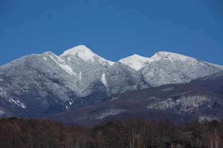
Mount Tengu is a 2,646 m peak straddling Chino City and Sakuho Town in Nagano Prefecture, the highest summit of the northern Yatsugatake within Yatsugatake-Chūshin Kōgen Quasi-National Park. The summit splits into two peaks about 300 m apart: the rounded, hai-matsu-clad West Tengu — nicknamed the "Blue Tengu" — and the rocky, exposed East Tengu, the "Red Tengu." Within the otherwise gentle forested terrain of the northern Yatsugatake, Mount Tengu alone shows the rugged character of the southern half, and its ridge offers wide views of Iō-dake and Aka-dake, the Northern and Southern Alps, and Mount Fuji. Listed in the Nihon Nihyaku Meizan, the Shinshū Hyakumeizan, and the Onsen Hyakumeizan, it is most often climbed from the Karasawa-kōsen, Shibu-no-yu, or Inago-yu trailheads, all of which converge at Kuroyuri-hütte before the final ridge — a well-maintained beginner-to-intermediate ascent.
Mount Tengu at a glance
- Weather: The most settled day in the next 7 days is Wed, November 4: clear, gusts up to 7 m/s.
- Route: The shortest is West and East Tengudake Loop from Karasawa Onsen: about 5 h 34 min, 8.6 km, about 870 m of climbing.
Mount Tengu weather (hourly, 14 days)
Sunrise today 06:10, sunset 16:50
| Tue, 11/3 | Wed, 11/4 | Thu, 11/5 | Fri, 11/6 | Sat, 11/7 | Sun, 11/8 | Mon, 11/9 | Tue, 11/10 | Wed, 11/11 | Thu, 11/12 | Fri, 11/13 | Sat, 11/14 | Sun, 11/15 | Mon, 11/16 | Tue, 11/17 | |||||||||||||||||||||||||||||||||||||||||||||||||||||||||||||||||||||||
|---|---|---|---|---|---|---|---|---|---|---|---|---|---|---|---|---|---|---|---|---|---|---|---|---|---|---|---|---|---|---|---|---|---|---|---|---|---|---|---|---|---|---|---|---|---|---|---|---|---|---|---|---|---|---|---|---|---|---|---|---|---|---|---|---|---|---|---|---|---|---|---|---|---|---|---|---|---|---|---|---|---|---|---|---|---|
| Japan time | 15 | 17 | 19 | 21 | 23 | 1 | 3 | 5 | 7 | 9 | 11 | 13 | 15 | 18 | 21 | 0 | 3 | 6 | 9 | 12 | 15 | 18 | 21 | 0 | 3 | 6 | 9 | 12 | 15 | 18 | 21 | 0 | 3 | 6 | 9 | 12 | 15 | 18 | 21 | 0 | 3 | 6 | 9 | 12 | 15 | 18 | 21 | 0 | 3 | 6 | 9 | 15 | 21 | 3 | 9 | 15 | 21 | 3 | 9 | 15 | 21 | 3 | 9 | 15 | 21 | 3 | 9 | 15 | 21 | 3 | 9 | 15 | 21 | 3 | 9 | 15 | 21 | 3 | 9 | 15 | 21 | 3 | 9 | 15 | |
  |   |  | | | | | | | | | |   |   | |   | | |   |   |   |  | | |   | |  | | | | |   | | | | | | | | | | | | | | | | | | | | | | | | | |   |   | | |  | | | | | |   | | | | | | | | | | | |   | | | | | ||
| Temperature | °C | 5° | 0° | -1° | -2° | -3° | -2° | -2° | -3° | -2° | 3° | 6° | 7° | 5° | 1° | 1° | 1° | 2° | 1° | 5° | 8° | 7° | 4° | 3° | 2° | 2° | 3° | 7° | 9° | 8° | 1° | -2° | -4° | -6° | -7° | -2° | 1° | 0° | -6° | -7° | -6° | -6° | -6° | 1° | 5° | 3° | -3° | -3° | -3° | -3° | -3° | 1° | 2° | -3° | -4° | 0° | 3° | -2° | -4° | -3° | -3° | -7° | -8° | 0° | 3° | -6° | -5° | -1° | 0° | -7° | -6° | 2° | 5° | -4° | -4° | 4° | 4° | 1° | 1° | 6° | 4° | -3° | -6° | 0° | 3° |
| Precipitation | mm | 2.3 | 8 | 3.9 | 0.4 | 0.7 | 0.1 | 0.1 | 0.3 | 0.3 | 0.2 | 9 | 11 | 1.4 | 0.8 | ||||||||||||||||||||||||||||||||||||||||||||||||||||||||||||||||||||||
| New snow | cm | 0.2 | 0.2 | <.1 | |||||||||||||||||||||||||||||||||||||||||||||||||||||||||||||||||||||||||||||||||
| Snow depth | cm | 0 | 0 | 0 | 0 | 0 | 0 | 0 | 0 | 0 | 0 | 0 | 0 | 0 | 0 | 0 | 0 | 0 | 0 | 0 | 0 | 0 | 0 | 0 | 0 | 0 | 0 | 0 | 0 | 0 | 0 | 0 | 0 | 0 | 0 | 0 | 0 | 0 | 0 | 0 | 0 | 0 | 0 | 0 | 0 | 0 | 0 | 0 | 0 | 0 | 0 | 0 | 0 | 0 | 0 | 0 | 0 | 0 | 0 | 0 | 0 | 0 | 0 | 0 | 0 | 0 | 0 | 0 | 0 | 0 | 0 | 0 | 0 | 0 | 0 | 0 | 0 | 0 | 0 | 0 | 0 | 0 | 0 | 0 | 0 |
| Wind | m/s | 1 | 0 | 0 | 0 | 0 | 0 | 0 | 0 | 0 | 1 | 1 | 1 | 1 | 2 | 2 | 2 | 1 | 0 | 1 | 0 | 1 | 1 | 1 | 1 | 2 | 1 | 2 | 3 | 3 | 1 | 1 | 2 | 2 | 2 | 3 | 4 | 3 | 1 | 1 | 1 | 1 | 1 | 1 | 1 | 1 | 0 | 1 | 0 | 1 | 1 | 1 | 2 | 1 | 1 | 2 | 4 | 2 | 3 | 5 | 4 | 1 | 1 | 2 | 2 | 0 | 1 | 3 | 2 | 1 | 1 | 1 | 2 | 1 | 2 | 3 | 2 | 2 | 2 | 2 | 3 | 2 | 1 | 1 | 1 |
| Wind gusts | m/s | 7 | 6 | 4 | 4 | 5 | 5 | 4 | 4 | 4 | 5 | 6 | 7 | 7 | 10 | 11 | 11 | 11 | 10 | 7 | 6 | 10 | 9 | 8 | 9 | 10 | 10 | 11 | 12 | 13 | 11 | 10 | 11 | 12 | 12 | 14 | 15 | 14 | 11 | 8 | 8 | 8 | 8 | 7 | 7 | 8 | 6 | 7 | 8 | 9 | 9 | 9 | 11 | 7 | 5 | 8 | 17 | 14 | 15 | 21 | 23 | 17 | 8 | 8 | 11 | 9 | 8 | 11 | 13 | 10 | 7 | 6 | 7 | 7 | 8 | 10 | 14 | 12 | 16 | 13 | 13 | 13 | 8 | 5 | 7 |
| Wind dir. | ↓ | ↓ | ↓ | ↓ | ↓ | ↓ | ↓ | ↓ | ↓ | ↓ | ↓ | ↓ | ↓ | ↓ | ↓ | ↓ | ↓ | ↓ | ↓ | ↓ | ↓ | ↓ | ↓ | ↓ | ↓ | ↓ | ↓ | ↓ | ↓ | ↓ | ↓ | ↓ | ↓ | ↓ | ↓ | ↓ | ↓ | ↓ | ↓ | ↓ | ↓ | ↓ | ↓ | ↓ | ↓ | ↓ | ↓ | ↓ | ↓ | ↓ | ↓ | ↓ | ↓ | ↓ | ↓ | ↓ | ↓ | ↓ | ↓ | ↓ | ↓ | ↓ | ↓ | ↓ | ↓ | ↓ | ↓ | ↓ | ↓ | ↓ | ↓ | ↓ | ↓ | ↓ | ↓ | ↓ | ↓ | ↓ | ↓ | ↓ | ↓ | ↓ | ↓ | ↓ | |
Mount Tengu hiking routes
Hiking times are estimates calculated from the terrain.
Huts, campsites and lodging near Mount Tengu
Mountain huts
- 根石岳山荘 2026: open April 25–November 25 · reservation required · sleeps 30
- Kuroyuri Hutte 2026: open all year · reservation required · sleeps 60
- Hutte Natsuzawa 2026: open July 1–August 31 · reservation required
- Yamabikoso temporarily closed
- 本沢温泉 2026: open all year · reservation required · sleeps 100
Campsites
- 黒百合ヒュッテ テント場
- 本沢温泉テント場
- 夏沢だけかんばキャンプ場
- ミドリ池キャンプ場
- 高見石小屋 テント場
Lodging
- Karasawa Kousen
- 稲子湯
Lists that include Mount Tengu
Japan 200 Famous Mountains · Japan's 300 Famous Mountains · 100 Famous Hot Spring Mountains · Koshinetsu 100 Famous Mountains · Shinshu 100 Famous Mountains · Shinshu Mountain Cards · Elevations of 1003 Mountains of Japan · 1000 Mountains of Japan
Mount Tengu facts
- Also known as
- 西天狗岳
- Elevation
- 2,646 m
- Location
- Chino, Nagano
36.019184, 138.355454 - National Park
- 八ヶ岳中信高原国定公園
- Website
- www.kuroyurihyutte.com
- Trail Map
- www.kuroyurihyutte.com
- Access Information
- www.kuroyurihyutte.com
- Wikipedia
- ja.wikipedia.org