
Mount Amigasa
編笠山
Fujimi, Nagano · Elevation 2,524 m
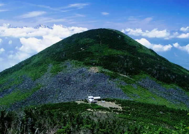
Mount Amigasa rises to 2,524 m on the border between Hokuto City's Kobuchisawa district in Yamanashi and Fujimi Town in Nagano, anchoring the southern end of the Yatsugatake range and falling within Yatsugatake-Chūshin-Kōgen Quasi-National Park, designated in 1964. The name evokes the rounded silhouette of an inverted bamboo travelling hat. The standard ascent leaves the Kannondaira trailhead and climbs via the Unkai (Sea of Clouds) viewpoint and Oshite-gawa for a round trip of about seven hours, finishing on a broad open summit. The view sweeps from Yatsugatake's principal peaks Aka, Amida, and Gongen to the Southern Alps, Mount Fuji, and Mount Ontake. The peak features in Yamanashi Hyakumeizan, Kōshū Hyakuzan, and Nagano's Meihō Hyakusen.
Mount Amigasa at a glance
- Weather: The most settled day in the next 7 days is Sun, November 8: clear, gusts up to 8 m/s. Fri, Nov 6, Sat, Nov 7: strong wind (gusts up to 18 m/s).
- Route: The shortest is Mount Amigasa and Seinen-goya Loop from Kannon-daira: about 5 h 30 min, 8.0 km, about 970 m of climbing.
Mount Amigasa weather (hourly, 14 days)
Sunrise today 06:10, sunset 16:50
| Tue, 11/3 | Wed, 11/4 | Thu, 11/5 | Fri, 11/6 | Sat, 11/7 | Sun, 11/8 | Mon, 11/9 | Tue, 11/10 | Wed, 11/11 | Thu, 11/12 | Fri, 11/13 | Sat, 11/14 | Sun, 11/15 | Mon, 11/16 | Tue, 11/17 | |||||||||||||||||||||||||||||||||||||||||||||||||||||||||||||||||||||||
|---|---|---|---|---|---|---|---|---|---|---|---|---|---|---|---|---|---|---|---|---|---|---|---|---|---|---|---|---|---|---|---|---|---|---|---|---|---|---|---|---|---|---|---|---|---|---|---|---|---|---|---|---|---|---|---|---|---|---|---|---|---|---|---|---|---|---|---|---|---|---|---|---|---|---|---|---|---|---|---|---|---|---|---|---|---|
| Japan time | 15 | 17 | 19 | 21 | 23 | 1 | 3 | 5 | 7 | 9 | 11 | 13 | 15 | 18 | 21 | 0 | 3 | 6 | 9 | 12 | 15 | 18 | 21 | 0 | 3 | 6 | 9 | 12 | 15 | 18 | 21 | 0 | 3 | 6 | 9 | 12 | 15 | 18 | 21 | 0 | 3 | 6 | 9 | 12 | 15 | 18 | 21 | 0 | 3 | 6 | 9 | 15 | 21 | 3 | 9 | 15 | 21 | 3 | 9 | 15 | 21 | 3 | 9 | 15 | 21 | 3 | 9 | 15 | 21 | 3 | 9 | 15 | 21 | 3 | 9 | 15 | 21 | 3 | 9 | 15 | 21 | 3 | 9 | 15 | |
 |   | | | | | | |   | | | |   |   | | | |   |   |   |   | | |  |   |   | | | | | | | | | | | | | | | | | | | | | | | | | |   | | | | | |   |   | | |  | | | | | | | | | | | | | | | | | | | |   | | | ||
| Temperature | °C | 8° | 3° | 1° | -1° | -1° | -1° | -2° | -3° | -2° | 4° | 7° | 7° | 5° | 2° | 1° | 2° | 2° | 2° | 6° | 10° | 7° | 4° | 4° | 2° | 2° | 3° | 7° | 10° | 10° | 3° | 0° | -2° | -5° | -6° | 0° | 2° | 1° | -4° | -6° | -6° | -6° | -6° | 2° | 7° | 6° | 0° | -1° | -2° | -1° | -1° | 3° | 6° | 0° | -2° | 2° | 4° | -1° | -4° | -3° | 0° | -7° | -8° | 1° | 4° | -4° | -5° | 1° | 3° | -6° | -7° | 2° | 6° | -3° | -4° | 3° | 5° | 2° | 2° | 7° | 8° | -1° | -5° | 0° | 4° |
| Precipitation | mm | 0.1 | 0.1 | 2.9 | 9 | 4.5 | 0.1 | 0.1 | 1.2 | 0.1 | 0.1 | 0.2 | 8 | 11 | 0.3 | 0.2 | |||||||||||||||||||||||||||||||||||||||||||||||||||||||||||||||||||||
| New snow | cm | <.1 | 0.2 | ||||||||||||||||||||||||||||||||||||||||||||||||||||||||||||||||||||||||||||||||||
| Snow depth | cm | 0 | 0 | 0 | 0 | 0 | 0 | 0 | 0 | 0 | 0 | 0 | 0 | 0 | 0 | 0 | 0 | 0 | 0 | 0 | 0 | 0 | 0 | 0 | 0 | 0 | 0 | 0 | 0 | 0 | 0 | 0 | 0 | 0 | 0 | 0 | 0 | 0 | 0 | 0 | 0 | 0 | 0 | 0 | 0 | 0 | 0 | 0 | 0 | 0 | 0 | 0 | 0 | 0 | 0 | 0 | 0 | 0 | 0 | 0 | 0 | 0 | 0 | 0 | 0 | 0 | 0 | 0 | 0 | 0 | 0 | 0 | 0 | 0 | 0 | 0 | 0 | 0 | 0 | 0 | 0 | 0 | 0 | 0 | 0 |
| Wind | m/s | 1 | 0 | 0 | 1 | 1 | 1 | 1 | 1 | 1 | 1 | 2 | 3 | 2 | 2 | 2 | 2 | 1 | 1 | 2 | 1 | 1 | 0 | 1 | 1 | 1 | 2 | 3 | 4 | 4 | 2 | 2 | 2 | 2 | 3 | 4 | 4 | 3 | 2 | 2 | 2 | 2 | 1 | 2 | 1 | 1 | 0 | 0 | 1 | 1 | 2 | 1 | 2 | 2 | 2 | 2 | 4 | 2 | 3 | 5 | 3 | 1 | 2 | 2 | 3 | 1 | 2 | 2 | 2 | 1 | 2 | 2 | 2 | 1 | 1 | 1 | 1 | 1 | 1 | 2 | 4 | 2 | 2 | 1 | 2 |
| Wind gusts | m/s | 8 | 5 | 4 | 5 | 5 | 5 | 5 | 5 | 4 | 6 | 8 | 9 | 9 | 9 | 10 | 11 | 11 | 9 | 7 | 7 | 9 | 8 | 6 | 8 | 9 | 10 | 12 | 15 | 16 | 14 | 12 | 11 | 12 | 14 | 17 | 18 | 17 | 14 | 10 | 9 | 9 | 9 | 8 | 7 | 8 | 6 | 6 | 7 | 7 | 8 | 8 | 13 | 8 | 6 | 8 | 14 | 13 | 16 | 22 | 21 | 14 | 7 | 8 | 12 | 10 | 10 | 11 | 12 | 10 | 8 | 7 | 8 | 6 | 7 | 7 | 10 | 9 | 12 | 11 | 16 | 15 | 9 | 6 | 7 |
| Wind dir. | ↓ | ↓ | ↓ | ↓ | ↓ | ↓ | ↓ | ↓ | ↓ | ↓ | ↓ | ↓ | ↓ | ↓ | ↓ | ↓ | ↓ | ↓ | ↓ | ↓ | ↓ | ↓ | ↓ | ↓ | ↓ | ↓ | ↓ | ↓ | ↓ | ↓ | ↓ | ↓ | ↓ | ↓ | ↓ | ↓ | ↓ | ↓ | ↓ | ↓ | ↓ | ↓ | ↓ | ↓ | ↓ | ↓ | ↓ | ↓ | ↓ | ↓ | ↓ | ↓ | ↓ | ↓ | ↓ | ↓ | ↓ | ↓ | ↓ | ↓ | ↓ | ↓ | ↓ | ↓ | ↓ | ↓ | ↓ | ↓ | ↓ | ↓ | ↓ | ↓ | ↓ | ↓ | ↓ | ↓ | ↓ | ↓ | ↓ | ↓ | ↓ | ↓ | ↓ | ↓ | |
Mount Amigasa hiking routes
- Mount Amigasa and Seinen-goya Loop from Kannon-daira 8.0 km · Ascent 972 m parking
- Mount Amigasa and Mount Nishidake Loop from Fujimi Kogen 11.7 km · Ascent 1,302 m parking
- Mount Amigasa, Mount Gongen and Mount Mitsugashira Circuit from Kannon-daira 11.4 km · Ascent 1,431 m parking
Hiking times are estimates calculated from the terrain.
Huts, campsites and lodging near Mount Amigasa
Mountain huts
- 青年小屋 2026: open April 25–November 5 · reservation required · sleeps 90
- 権現小屋 temporarily closed
- Kiretto Hut temporarily closed
- 出合小屋
- 赤岳頂上山荘 2026: open June 19–October 25 · reservation required · sleeps 100
Campsites
- 青年小屋テントサイト
- 行者小屋テント場
Lodging
- HAPPOU-EN "SHIKANO-YU"
- 川崎市八ヶ岳少年自然の家
- RYOZO
- Polar Star
Lists that include Mount Amigasa
Yamanashi 100 Famous Mountains · Mountains of Hokuto · Elevations of 1003 Mountains of Japan · 1000 Mountains of Japan
Mount Amigasa facts
- Elevation
- 2,524 m
- Location
- Fujimi, Nagano
35.941728, 138.345069 - National Park
- 八ヶ岳中信高原国定公園
- Website
- www.city.hokuto.yamanashi.jp
- Wikipedia
- ja.wikipedia.org