
Mount Tateshina
蓼科山
Chino, Nagano · Elevation 2,531 m
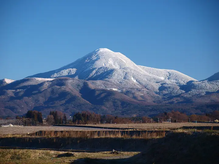
Mount Tateshina is a 2,531 m stratovolcano on the boundary between Chino City and Tateshina Town in Nagano Prefecture, marking the northern end of the Yatsugatake range. Its symmetrical conical profile has earned it the nickname Suwa-Fuji, and it lies within Yatsugatake-Chūshin-Kōgen Quasi-National Park. The broad summit is a boulder-strewn plateau with a 360-degree panorama over the Northern Alps, Mount Asama, Kirigamine, and the rest of Yatsugatake. Standard routes climb from the Shichigōme trailhead (the shortest), the Megami-jaya / Tateshinayama trailhead, Ōkawara-tōge, and Ryūgenbashi by Lake Shirakaba; the Tateshina-Sanchō Hütte and the Tateshina-Sansō hut serve climbers near the top.
Mount Tateshina at a glance
- Weather: The most settled day in the next 7 days is Wed, November 4: clear, gusts up to 6 m/s.
- Route: The shortest is Mount Tateshina Return from the Seventh Station: about 3 h 25 min, 4.8 km, about 630 m of climbing.
Mount Tateshina weather (hourly, 14 days)
Sunrise today 06:11, sunset 16:50
| Tue, 11/3 | Wed, 11/4 | Thu, 11/5 | Fri, 11/6 | Sat, 11/7 | Sun, 11/8 | Mon, 11/9 | Tue, 11/10 | Wed, 11/11 | Thu, 11/12 | Fri, 11/13 | Sat, 11/14 | Sun, 11/15 | Mon, 11/16 | Tue, 11/17 | |||||||||||||||||||||||||||||||||||||||||||||||||||||||||||||||||||||||
|---|---|---|---|---|---|---|---|---|---|---|---|---|---|---|---|---|---|---|---|---|---|---|---|---|---|---|---|---|---|---|---|---|---|---|---|---|---|---|---|---|---|---|---|---|---|---|---|---|---|---|---|---|---|---|---|---|---|---|---|---|---|---|---|---|---|---|---|---|---|---|---|---|---|---|---|---|---|---|---|---|---|---|---|---|---|
| Japan time | 15 | 17 | 19 | 21 | 23 | 1 | 3 | 5 | 7 | 9 | 11 | 13 | 15 | 18 | 21 | 0 | 3 | 6 | 9 | 12 | 15 | 18 | 21 | 0 | 3 | 6 | 9 | 12 | 15 | 18 | 21 | 0 | 3 | 6 | 9 | 12 | 15 | 18 | 21 | 0 | 3 | 6 | 9 | 12 | 15 | 18 | 21 | 0 | 3 | 6 | 9 | 15 | 21 | 3 | 9 | 15 | 21 | 3 | 9 | 15 | 21 | 3 | 9 | 15 | 21 | 3 | 9 | 15 | 21 | 3 | 9 | 15 | 21 | 3 | 9 | 15 | 21 | 3 | 9 | 15 | 21 | 3 | 9 | 15 | |
  |   |  | | | | | | | | | |   |   | |   | |   |   | |   |  |   | | | |  | | | | | | | | | | | | | | | | | | | | | | | | | | | | | | |   |   | | |  | | | | |   | | | | | | | | | | | | |   | | | | | ||
| Temperature | °C | 1° | -3° | -5° | -5° | -5° | -5° | -4° | -6° | -5° | 0° | 3° | 5° | 3° | -1° | -2° | -2° | -1° | -1° | 1° | 5° | 4° | 2° | 1° | 0° | 0° | 1° | 5° | 7° | 6° | -1° | -3° | -5° | -6° | -7° | -4° | -1° | -3° | -8° | -9° | -9° | -10° | -10° | -3° | 1° | -2° | -6° | -6° | -6° | -5° | -5° | -1° | -1° | -6° | -6° | -2° | 1° | -4° | -6° | -5° | -5° | -9° | -9° | -2° | 1° | -8° | -6° | -3° | -4° | -9° | -9° | -1° | 3° | -5° | -5° | 2° | 2° | 0° | 0° | 5° | 0° | -6° | -9° | -3° | 1° |
| Precipitation | mm | 1.6 | 9 | 3.7 | 1.2 | 0.1 | 0.3 | 0.2 | 0.1 | 0.6 | 0.3 | 0.3 | 10 | 10 | 2.5 | 0.7 | |||||||||||||||||||||||||||||||||||||||||||||||||||||||||||||||||||||
| New snow | cm | 0.2 | 0.1 | <.1 | |||||||||||||||||||||||||||||||||||||||||||||||||||||||||||||||||||||||||||||||||
| Snow depth | cm | 0 | 0 | 0 | 0 | 0 | 0 | 0 | 0 | 0 | 0 | 0 | 0 | 0 | 0 | 0 | 0 | 0 | 0 | 0 | 0 | 0 | 0 | 0 | 0 | 0 | 0 | 0 | 0 | 0 | 0 | 0 | 0 | 0 | 0 | 0 | 0 | 0 | 0 | 0 | 0 | 0 | 0 | 0 | 0 | 0 | 0 | 0 | 0 | 0 | 0 | 0 | 0 | 0 | 0 | 0 | 0 | 0 | 0 | 0 | 0 | 0 | 0 | 0 | 0 | 0 | 0 | 0 | 0 | 0 | 0 | 0 | 0 | 0 | 0 | 0 | 0 | 0 | 0 | 0 | 0 | 0 | 0 | 0 | 0 |
| Wind | m/s | 2 | 0 | 1 | 1 | 0 | 0 | 0 | 0 | 0 | 1 | 1 | 0 | 2 | 2 | 2 | 1 | 1 | 1 | 0 | 1 | 2 | 1 | 1 | 2 | 3 | 3 | 3 | 4 | 4 | 3 | 3 | 4 | 4 | 4 | 3 | 5 | 4 | 2 | 1 | 1 | 1 | 0 | 1 | 2 | 2 | 1 | 1 | 1 | 1 | 2 | 1 | 2 | 1 | 1 | 1 | 4 | 3 | 6 | 4 | 4 | 0 | 1 | 2 | 2 | 0 | 3 | 3 | 3 | 0 | 1 | 1 | 1 | 2 | 3 | 3 | 2 | 2 | 4 | 3 | 4 | 2 | 1 | 1 | 1 |
| Wind gusts | m/s | 6 | 6 | 3 | 3 | 3 | 3 | 3 | 2 | 3 | 4 | 5 | 5 | 6 | 7 | 6 | 6 | 6 | 7 | 6 | 6 | 7 | 7 | 5 | 8 | 9 | 9 | 11 | 13 | 13 | 12 | 9 | 10 | 12 | 12 | 12 | 15 | 14 | 11 | 6 | 5 | 5 | 5 | 5 | 7 | 8 | 7 | 5 | 6 | 6 | 7 | 7 | 9 | 5 | 4 | 6 | 13 | 13 | 16 | 17 | 17 | 12 | 4 | 6 | 10 | 8 | 7 | 8 | 10 | 8 | 4 | 4 | 6 | 6 | 9 | 10 | 15 | 8 | 15 | 12 | 12 | 11 | 6 | 4 | 6 |
| Wind dir. | ↓ | ↓ | ↓ | ↓ | ↓ | ↓ | ↓ | ↓ | ↓ | ↓ | ↓ | ↓ | ↓ | ↓ | ↓ | ↓ | ↓ | ↓ | ↓ | ↓ | ↓ | ↓ | ↓ | ↓ | ↓ | ↓ | ↓ | ↓ | ↓ | ↓ | ↓ | ↓ | ↓ | ↓ | ↓ | ↓ | ↓ | ↓ | ↓ | ↓ | ↓ | ↓ | ↓ | ↓ | ↓ | ↓ | ↓ | ↓ | ↓ | ↓ | ↓ | ↓ | ↓ | ↓ | ↓ | ↓ | ↓ | ↓ | ↓ | ↓ | ↓ | ↓ | ↓ | ↓ | ↓ | ↓ | ↓ | ↓ | ↓ | ↓ | ↓ | ↓ | ↓ | ↓ | ↓ | ↓ | ↓ | ↓ | ↓ | ↓ | ↓ | ↓ | ↓ | ||
Mount Tateshina hiking routes
- Mount Tateshina Return from the Seventh Station 4.8 km · Ascent 634 m 蓼科山七合目登山口 (parking)
- Mount Tateshina Loop via Suzuran Pass and Ryugen Bridge 9.7 km · Ascent 909 m すずらん峠園地駐車場
- Mount Tateshina, Futago Ponds and Mount Futago Loop from Ogawara Pass 9.9 km · Ascent 807 m parking
Hiking times are estimates calculated from the terrain.
Huts, campsites and lodging near Mount Tateshina
Mountain huts
- Tateshinasancho Hutte 2026: open April 25–October 31 · reservation required · sleeps 33
- Tateshinasanso 2026: open April 25–October 31 · reservation required · sleeps 18
- Ogawara Hutte temporarily closed
- Kita-Yokodake Hut 2024: open all year · reservation required · sleeps 20
- Futagoike Hutte 2026: open April 25–November 7 · reservation required · sleeps 40
Campsites
- 双子池キャンプ場
- 夢の平キャンプ場
Lodging
- ペンション ラクーン
- Colosseum Inn
- アルペンドルフ
- ブルーベリー
- The Colonial House
Lists that include Mount Tateshina
100 Famous Japanese Mountains · Japan 200 Famous Mountains · Japan's 300 Famous Mountains · New 100 Famous Flower Mountains · 100 Famous Mountains with First-order Triangulation Points · 100 Fujis of Japan · Koshinetsu 100 Famous Mountains · Shinshu 100 Famous Mountains · Shinshu Mountain Cards · Elevations of 1003 Mountains of Japan · 1000 Mountains of Japan
Mount Tateshina facts
- Also known as
- 諏訪富士 · 高井山 · 飯盛山 · 黒斑山 · 女ノ神山
- Elevation
- 2,531 m
- Location
- Chino, Nagano
36.103733, 138.295094 - National Park
- 八ヶ岳中信高原国定公園
- Website
- www.city.chino.lg.jp
- Trail Map
- www.tateshinayama.com
- Wikipedia
- ja.wikipedia.org