
Mt. Sanshahō
三叉峰
Chino, Nagano · Elevation 2,825 m
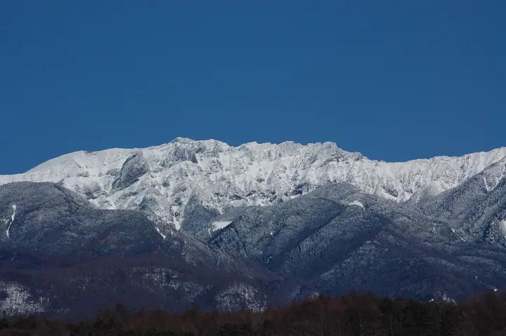
Mt. Sanshahō is a 2,825 m rocky peak on the main ridge of the Yatsugatake Range, straddling Chino and Hara in Nagano Prefecture, and one of several minor summits making up Mt. Yokodake (high point 2,830 m). It rises where the Somazo Ridge merges with the main ridge and serves as a key waypoint on the Yokodake traverse. Set within Yatsugatake-Chūshin-Kōgen Quasi-National Park, the peak appears in Tōkyō Shūhen no Yama 350 and Shizuka-naru One-aruki.
Mt. Sanshahō at a glance
- Weather: The most settled day in the next 7 days is Sun, November 8: clear, gusts up to 8 m/s. Fri, Nov 6, Sat, Nov 7: strong wind (gusts up to 18 m/s).
- Route: The shortest is Yokodake’s Okunoin via Somazoe Ridge: about 6 h 28 min, 9.4 km, about 1,130 m of climbing.
Mt. Sanshahō weather (hourly, 14 days)
Sunrise today 06:10, sunset 16:50
| Tue, 11/3 | Wed, 11/4 | Thu, 11/5 | Fri, 11/6 | Sat, 11/7 | Sun, 11/8 | Mon, 11/9 | Tue, 11/10 | Wed, 11/11 | Thu, 11/12 | Fri, 11/13 | Sat, 11/14 | Sun, 11/15 | Mon, 11/16 | Tue, 11/17 | |||||||||||||||||||||||||||||||||||||||||||||||||||||||||||||||||||||||
|---|---|---|---|---|---|---|---|---|---|---|---|---|---|---|---|---|---|---|---|---|---|---|---|---|---|---|---|---|---|---|---|---|---|---|---|---|---|---|---|---|---|---|---|---|---|---|---|---|---|---|---|---|---|---|---|---|---|---|---|---|---|---|---|---|---|---|---|---|---|---|---|---|---|---|---|---|---|---|---|---|---|---|---|---|---|
| Japan time | 15 | 17 | 19 | 21 | 23 | 1 | 3 | 5 | 7 | 9 | 11 | 13 | 15 | 18 | 21 | 0 | 3 | 6 | 9 | 12 | 15 | 18 | 21 | 0 | 3 | 6 | 9 | 12 | 15 | 18 | 21 | 0 | 3 | 6 | 9 | 12 | 15 | 18 | 21 | 0 | 3 | 6 | 9 | 12 | 15 | 18 | 21 | 0 | 3 | 6 | 9 | 15 | 21 | 3 | 9 | 15 | 21 | 3 | 9 | 15 | 21 | 3 | 9 | 15 | 21 | 3 | 9 | 15 | 21 | 3 | 9 | 15 | 21 | 3 | 9 | 15 | 21 | 3 | 9 | 15 | 21 | 3 | 9 | 15 | |
 |   | | | | | | |   | | | |   |   | | | |   |   |   |   | | |  |   |   | | | | | | | | | | | | | | | | | | | | | | | | | |   | | | | | |   |   | | |  | | | | | | | | | | | | | | | | | | | |   | | | ||
| Temperature | °C | 6° | 1° | -1° | -3° | -3° | -3° | -4° | -5° | -4° | 2° | 5° | 5° | 3° | 0° | -1° | 0° | 0° | 0° | 4° | 8° | 5° | 2° | 2° | 1° | 0° | 1° | 5° | 9° | 8° | 1° | -2° | -4° | -7° | -8° | -2° | 0° | -1° | -6° | -8° | -8° | -8° | -8° | 0° | 5° | 4° | -2° | -2° | -4° | -3° | -3° | 1° | 4° | -2° | -4° | 0° | 2° | -3° | -6° | -4° | -2° | -9° | -10° | -1° | 2° | -6° | -7° | -1° | 1° | -8° | -9° | 0° | 4° | -5° | -6° | 1° | 3° | 0° | 0° | 5° | 6° | -3° | -7° | -1° | 2° |
| Precipitation | mm | 0.1 | 0.1 | 2.9 | 9 | 4.5 | 0.1 | 0.1 | 1.2 | 0.1 | 0.1 | 0.2 | 8 | 11 | 0.3 | 0.2 | |||||||||||||||||||||||||||||||||||||||||||||||||||||||||||||||||||||
| New snow | cm | <.1 | 0.2 | ||||||||||||||||||||||||||||||||||||||||||||||||||||||||||||||||||||||||||||||||||
| Snow depth | cm | 0 | 0 | 0 | 0 | 0 | 0 | 0 | 0 | 0 | 0 | 0 | 0 | 0 | 0 | 0 | 0 | 0 | 0 | 0 | 0 | 0 | 0 | 0 | 0 | 0 | 0 | 0 | 0 | 0 | 0 | 0 | 0 | 0 | 0 | 0 | 0 | 0 | 0 | 0 | 0 | 0 | 0 | 0 | 0 | 0 | 0 | 0 | 0 | 0 | 0 | 0 | 0 | 0 | 0 | 0 | 0 | 0 | 0 | 0 | 0 | 0 | 0 | 0 | 0 | 0 | 0 | 0 | 0 | 0 | 0 | 0 | 0 | 0 | 0 | 0 | 0 | 0 | 0 | 0 | 0 | 0 | 0 | 0 | 0 |
| Wind | m/s | 1 | 0 | 0 | 1 | 1 | 1 | 1 | 1 | 1 | 1 | 2 | 3 | 2 | 2 | 2 | 2 | 1 | 1 | 2 | 1 | 1 | 0 | 1 | 1 | 1 | 2 | 3 | 4 | 4 | 2 | 2 | 2 | 2 | 3 | 4 | 4 | 3 | 2 | 2 | 2 | 2 | 1 | 2 | 1 | 1 | 0 | 0 | 1 | 1 | 2 | 1 | 2 | 2 | 2 | 2 | 4 | 2 | 3 | 5 | 3 | 1 | 2 | 2 | 3 | 1 | 2 | 2 | 2 | 1 | 2 | 2 | 2 | 1 | 1 | 1 | 1 | 1 | 1 | 2 | 4 | 2 | 2 | 1 | 2 |
| Wind gusts | m/s | 8 | 5 | 4 | 5 | 5 | 5 | 5 | 5 | 4 | 6 | 8 | 9 | 9 | 9 | 10 | 11 | 11 | 9 | 7 | 7 | 9 | 8 | 6 | 8 | 9 | 10 | 12 | 15 | 16 | 14 | 12 | 11 | 12 | 14 | 17 | 18 | 17 | 14 | 10 | 9 | 9 | 9 | 8 | 7 | 8 | 6 | 6 | 7 | 7 | 8 | 8 | 13 | 8 | 6 | 8 | 14 | 13 | 16 | 22 | 21 | 14 | 7 | 8 | 12 | 10 | 10 | 11 | 12 | 10 | 8 | 7 | 8 | 6 | 7 | 7 | 10 | 9 | 12 | 11 | 16 | 15 | 9 | 6 | 7 |
| Wind dir. | ↓ | ↓ | ↓ | ↓ | ↓ | ↓ | ↓ | ↓ | ↓ | ↓ | ↓ | ↓ | ↓ | ↓ | ↓ | ↓ | ↓ | ↓ | ↓ | ↓ | ↓ | ↓ | ↓ | ↓ | ↓ | ↓ | ↓ | ↓ | ↓ | ↓ | ↓ | ↓ | ↓ | ↓ | ↓ | ↓ | ↓ | ↓ | ↓ | ↓ | ↓ | ↓ | ↓ | ↓ | ↓ | ↓ | ↓ | ↓ | ↓ | ↓ | ↓ | ↓ | ↓ | ↓ | ↓ | ↓ | ↓ | ↓ | ↓ | ↓ | ↓ | ↓ | ↓ | ↓ | ↓ | ↓ | ↓ | ↓ | ↓ | ↓ | ↓ | ↓ | ↓ | ↓ | ↓ | ↓ | ↓ | ↓ | ↓ | ↓ | ↓ | ↓ | ↓ | ↓ | |
Mt. Sanshahō hiking routes
- Yokodake’s Okunoin via Somazoe Ridge 9.4 km · Ascent 1,129 m 横岳登山口 (parking)
- Mount Akadake, Yokodake and Iodake Circuit from Minotoguchi 21.5 km · Ascent 1,718 m 美濃戸口 (Bus stop) (parking)
- Southern Yatsugatake Main-Ridge Circuit 20.7 km · Ascent 1,934 m 美濃戸口 (Bus stop) (parking)
Hiking times are estimates calculated from the terrain.
Huts, campsites and lodging near Mt. Sanshahō
Mountain huts
- 赤岳展望荘 2026: open April 24–November 3 · reservation required · sleeps 138
- Gyoja Goya 2026: open May 30–October 31 · reservation required · sleeps 80
- Iodake Sanso 2026: open April 25–November 5 · reservation required · sleeps 80
- Akadake Kosen 2026: open all year · reservation required
- 赤岳頂上山荘 2026: open June 19–October 25 · reservation required · sleeps 100
Campsites
- 行者小屋テント場
- 赤岳鉱泉テント場
- 夏沢だけかんばキャンプ場
- 本沢温泉テント場
- 青年小屋テントサイト
Mt. Sanshahō facts
- Also known as
- 横岳
- Elevation
- 2,825 m
- Location
- Chino, Nagano
35.983098, 138.374273 - National Park
- 八ヶ岳中信高原国定公園
- Trail Map
- www.vill.hara.lg.jp (PDF)
- Access Information
- www.vill.hara.lg.jp
- Wikipedia
- ja.wikipedia.org