
Mt. Karasugasen
烏ヶ山
Kōfu-chō, Tottori / Kotoura, Tottori · Elevation 1,448 m
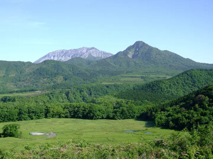
Mt. Karasugasen is a sharp 1,448 m peak on the border of Kotoura Town (Tohaku District) and Kofu Town (Hino District) in Tottori Prefecture, rising independently southeast of Mt. Daisen. Nicknamed the "Matterhorn of San'in" for its pyramidal shape, it lies within the Oku-Daisen sector of Daisen-Oki National Park. As the third-highest peak in the Chugoku region, it is included in the 100 Famous Mountains of Chugoku, the 1003 Mountains of Japan, and the 100 Mountains of the Chugoku Region. Trails were heavily damaged by the 2000 Western Tottori and 2016 Central Tottori earthquakes; the Kagamiganaru route reopened in 2016, while the northern Torigoe ridge route remains closed.
Mt. Karasugasen at a glance
- Weather: The most settled day in the next 7 days is Wed, November 4: clear, gusts up to 7 m/s. Fri, Nov 6, Sat, Nov 7: strong wind (gusts up to 16 m/s).
- Route: The shortest is Mount Karasugasen and Shingoya Pass Loop from Kagamiganaru: about 3 h 28 min, 5.7 km, about 610 m of climbing.
Mt. Karasugasen weather (hourly, 14 days)
Sunrise today 06:28, sunset 17:10
| Tue, 11/3 | Wed, 11/4 | Thu, 11/5 | Fri, 11/6 | Sat, 11/7 | Sun, 11/8 | Mon, 11/9 | Tue, 11/10 | Wed, 11/11 | Thu, 11/12 | Fri, 11/13 | Sat, 11/14 | Sun, 11/15 | Mon, 11/16 | Tue, 11/17 | |||||||||||||||||||||||||||||||||||||||||||||||||||||||||||||||||||||||
|---|---|---|---|---|---|---|---|---|---|---|---|---|---|---|---|---|---|---|---|---|---|---|---|---|---|---|---|---|---|---|---|---|---|---|---|---|---|---|---|---|---|---|---|---|---|---|---|---|---|---|---|---|---|---|---|---|---|---|---|---|---|---|---|---|---|---|---|---|---|---|---|---|---|---|---|---|---|---|---|---|---|---|---|---|---|
| Japan time | 15 | 17 | 19 | 21 | 23 | 1 | 3 | 5 | 7 | 9 | 11 | 13 | 15 | 18 | 21 | 0 | 3 | 6 | 9 | 12 | 15 | 18 | 21 | 0 | 3 | 6 | 9 | 12 | 15 | 18 | 21 | 0 | 3 | 6 | 9 | 12 | 15 | 18 | 21 | 0 | 3 | 6 | 9 | 12 | 15 | 18 | 21 | 0 | 3 | 6 | 9 | 15 | 21 | 3 | 9 | 15 | 21 | 3 | 9 | 15 | 21 | 3 | 9 | 15 | 21 | 3 | 9 | 15 | 21 | 3 | 9 | 15 | 21 | 3 | 9 | 15 | 21 | 3 | 9 | 15 | 21 | 3 | 9 | 15 | |
  | |   | | |   |   | |   |   | | | | | | |   |   | |   | | | | | | | | | | | | | | |   | | | | |  | | | | | | | | | | | | |   | | | | | | | | | |  | | | | | | |  | | | | | | | | | | | | | | | ||
| Temperature | °C | 8° | 6° | 5° | 5° | 5° | 4° | 4° | 3° | 3° | 8° | 10° | 10° | 10° | 6° | 6° | 6° | 6° | 7° | 10° | 11° | 10° | 9° | 9° | 8° | 8° | 7° | 9° | 10° | 8° | 5° | 4° | 4° | 3° | 2° | 4° | 5° | 5° | 3° | 2° | 0° | 0° | 0° | 5° | 7° | 6° | 4° | 3° | 3° | 3° | 3° | 5° | 6° | 2° | 1° | 4° | 5° | 2° | 0° | 3° | 3° | 2° | 1° | 4° | 8° | 3° | 3° | 4° | 5° | 1° | -1° | 6° | 10° | 4° | 5° | 8° | 8° | 8° | 8° | 8° | 5° | 3° | 1° | 3° | 4° |
| Precipitation | mm | 0.8 | 0.5 | 0.4 | 0.2 | 0.1 | 0.4 | 1.0 | 3.5 | 3.7 | 3.5 | 12 | 0.8 | 0.4 | 0.4 | 0.8 | 0.9 | 0.6 | 0.2 | 2.2 | 0.3 | 1.1 | 2.1 | 0.9 | 1.6 | 0.5 | 1.8 | 0.8 | 1.5 | 3.1 | 0.5 | 6 | 17 | 1.6 | 7 | 9 | 6 | 0.3 | 0.1 | ||||||||||||||||||||||||||||||||||||||||||||||
| New snow | cm | ||||||||||||||||||||||||||||||||||||||||||||||||||||||||||||||||||||||||||||||||||||
| Snow depth | cm | 0 | 0 | 0 | 0 | 0 | 0 | 0 | 0 | 0 | 0 | 0 | 0 | 0 | 0 | 0 | 0 | 0 | 0 | 0 | 0 | 0 | 0 | 0 | 0 | 0 | 0 | 0 | 0 | 0 | 0 | 0 | 0 | 0 | 0 | 0 | 0 | 0 | 0 | 0 | 0 | 0 | 0 | 0 | 0 | 0 | 0 | 0 | 0 | 0 | 0 | 0 | 0 | 0 | 0 | 0 | 0 | 0 | 0 | 0 | 0 | 0 | 0 | 0 | 0 | 0 | 0 | 0 | 0 | 0 | 0 | 0 | 0 | 0 | 0 | 0 | 0 | 0 | 0 | 0 | 0 | 0 | 0 | 0 | 0 |
| Wind | m/s | 2 | 0 | 0 | 0 | 1 | 0 | 1 | 1 | 2 | 2 | 2 | 2 | 2 | 1 | 2 | 1 | 1 | 0 | 1 | 1 | 1 | 1 | 1 | 1 | 2 | 3 | 3 | 6 | 5 | 4 | 5 | 4 | 5 | 5 | 6 | 5 | 5 | 2 | 1 | 1 | 0 | 0 | 1 | 3 | 2 | 1 | 0 | 1 | 1 | 1 | 2 | 2 | 2 | 1 | 4 | 5 | 5 | 5 | 4 | 3 | 1 | 1 | 1 | 4 | 2 | 2 | 3 | 3 | 1 | 1 | 1 | 1 | 3 | 3 | 4 | 6 | 1 | 2 | 3 | 4 | 3 | 2 | 2 | 1 |
| Wind gusts | m/s | 7 | 7 | 3 | 3 | 3 | 3 | 4 | 5 | 5 | 6 | 7 | 7 | 7 | 7 | 6 | 8 | 5 | 5 | 4 | 5 | 5 | 7 | 7 | 8 | 8 | 11 | 12 | 16 | 16 | 15 | 15 | 15 | 15 | 15 | 16 | 16 | 15 | 14 | 7 | 5 | 4 | 4 | 5 | 9 | 10 | 6 | 3 | 4 | 4 | 5 | 8 | 10 | 9 | 6 | 11 | 15 | 15 | 18 | 15 | 12 | 9 | 4 | 5 | 12 | 11 | 8 | 10 | 11 | 10 | 5 | 5 | 6 | 8 | 10 | 12 | 20 | 20 | 12 | 10 | 13 | 13 | 9 | 7 | 7 |
| Wind dir. | ↓ | ↓ | ↓ | ↓ | ↓ | ↓ | ↓ | ↓ | ↓ | ↓ | ↓ | ↓ | ↓ | ↓ | ↓ | ↓ | ↓ | ↓ | ↓ | ↓ | ↓ | ↓ | ↓ | ↓ | ↓ | ↓ | ↓ | ↓ | ↓ | ↓ | ↓ | ↓ | ↓ | ↓ | ↓ | ↓ | ↓ | ↓ | ↓ | ↓ | ↓ | ↓ | ↓ | ↓ | ↓ | ↓ | ↓ | ↓ | ↓ | ↓ | ↓ | ↓ | ↓ | ↓ | ↓ | ↓ | ↓ | ↓ | ↓ | ↓ | ↓ | ↓ | ↓ | ↓ | ↓ | ↓ | ↓ | ↓ | ↓ | ↓ | ↓ | ↓ | ↓ | ↓ | ↓ | ↓ | ↓ | ↓ | ↓ | ↓ | ↓ | ↓ | ↓ | ↓ | |
Mt. Karasugasen hiking routes
Hiking times are estimates calculated from the terrain.
Huts, campsites and lodging near Mt. Karasugasen
Mountain huts
Campsites
- 休暇村鏡ケ成キャンプ場
- 一向平キャンプ場
Lodging
- 休暇村奥大山
Lists that include Mt. Karasugasen
Chugoku 100 Famous Mountains · Elevations of 1003 Mountains of Japan · 1000 Mountains of Japan
Mt. Karasugasen facts
- Elevation
- 1,448 m
- Location
- Kōfu-chō, Tottori / Kotoura, Tottori
35.355819, 133.570463 - National Park
- 大山隠岐国立公園
- Website
- chushikoku.env.go.jp
- Trail Map
- www.pref.tottori.lg.jp (PDF)
- Wikipedia
- ja.wikipedia.org