
Mount Daisen
大山
Daisen, Tottori · Elevation 1,709 m
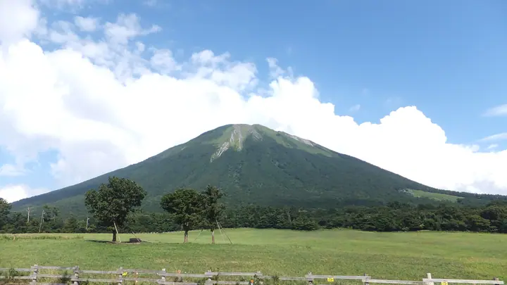
Mount Daisen (Misen, 1,709.4 m) is a freestanding peak in Daisen Town, Tottori Prefecture, the highest mountain in the Chūgoku region and nicknamed "Hōki Fuji." The true summit is Kengamine (1,729 m), but its traverse is officially discouraged due to severe erosion, so general hikers regard Misen as the de-facto top. Forming the heart of Daisen-Oki National Park, the mountain is known for its primeval beech forests, the largest grove of Daisen Japanese yew, and the religious cultural landscape around Daisen-ji. It is listed in the 100 Famous Japanese Mountains and the Hundred Flowering Mountains.
Mount Daisen at a glance
- Weather: The most settled day in the next 7 days is Wed, November 4: clear, gusts up to 7 m/s. Fri, Nov 6, Sat, Nov 7: strong wind (gusts up to 16 m/s).
- Route: The shortest is Mount Daisen (Misen) Circuit via Natsuyama and Gyojadani Trails: about 5 h 7 min, 7.8 km, about 960 m of climbing.
Mount Daisen weather (hourly, 14 days)
Sunrise today 06:29, sunset 17:10
| Tue, 11/3 | Wed, 11/4 | Thu, 11/5 | Fri, 11/6 | Sat, 11/7 | Sun, 11/8 | Mon, 11/9 | Tue, 11/10 | Wed, 11/11 | Thu, 11/12 | Fri, 11/13 | Sat, 11/14 | Sun, 11/15 | Mon, 11/16 | Tue, 11/17 | |||||||||||||||||||||||||||||||||||||||||||||||||||||||||||||||||||||||
|---|---|---|---|---|---|---|---|---|---|---|---|---|---|---|---|---|---|---|---|---|---|---|---|---|---|---|---|---|---|---|---|---|---|---|---|---|---|---|---|---|---|---|---|---|---|---|---|---|---|---|---|---|---|---|---|---|---|---|---|---|---|---|---|---|---|---|---|---|---|---|---|---|---|---|---|---|---|---|---|---|---|---|---|---|---|
| Japan time | 15 | 17 | 19 | 21 | 23 | 1 | 3 | 5 | 7 | 9 | 11 | 13 | 15 | 18 | 21 | 0 | 3 | 6 | 9 | 12 | 15 | 18 | 21 | 0 | 3 | 6 | 9 | 12 | 15 | 18 | 21 | 0 | 3 | 6 | 9 | 12 | 15 | 18 | 21 | 0 | 3 | 6 | 9 | 12 | 15 | 18 | 21 | 0 | 3 | 6 | 9 | 15 | 21 | 3 | 9 | 15 | 21 | 3 | 9 | 15 | 21 | 3 | 9 | 15 | 21 | 3 | 9 | 15 | 21 | 3 | 9 | 15 | 21 | 3 | 9 | 15 | 21 | 3 | 9 | 15 | 21 | 3 | 9 | 15 | |
  | |   | | |   |   | |   |   | | | | | | |   |   | |   | | | | | | | | | | | | | | |   | | | | |  | | | | | | | | | | | | |   | | | | | | | | | |  | | | | | | |  | | | | | | | | | | | | | | | ||
| Temperature | °C | 6° | 4° | 3° | 3° | 3° | 3° | 2° | 1° | 1° | 6° | 8° | 9° | 8° | 4° | 5° | 5° | 4° | 6° | 9° | 9° | 8° | 8° | 7° | 6° | 6° | 5° | 7° | 8° | 7° | 3° | 2° | 3° | 1° | 1° | 2° | 4° | 4° | 1° | 0° | -1° | -2° | -2° | 4° | 6° | 4° | 2° | 2° | 2° | 2° | 1° | 4° | 5° | 0° | 0° | 3° | 4° | 0° | -1° | 1° | 1° | 0° | -1° | 3° | 6° | 2° | 1° | 2° | 3° | 0° | -3° | 4° | 9° | 2° | 3° | 6° | 6° | 7° | 7° | 6° | 3° | 1° | 0° | 2° | 2° |
| Precipitation | mm | 0.8 | 0.5 | 0.4 | 0.2 | 0.1 | 0.4 | 1.0 | 3.5 | 3.7 | 3.5 | 12 | 0.8 | 0.4 | 0.4 | 0.8 | 0.9 | 0.6 | 0.2 | 2.2 | 0.3 | 1.1 | 2.1 | 0.9 | 1.6 | 0.5 | 1.8 | 0.8 | 1.5 | 3.1 | 0.5 | 6 | 17 | 1.6 | 7 | 9 | 6 | 0.3 | 0.1 | ||||||||||||||||||||||||||||||||||||||||||||||
| New snow | cm | ||||||||||||||||||||||||||||||||||||||||||||||||||||||||||||||||||||||||||||||||||||
| Snow depth | cm | 0 | 0 | 0 | 0 | 0 | 0 | 0 | 0 | 0 | 0 | 0 | 0 | 0 | 0 | 0 | 0 | 0 | 0 | 0 | 0 | 0 | 0 | 0 | 0 | 0 | 0 | 0 | 0 | 0 | 0 | 0 | 0 | 0 | 0 | 0 | 0 | 0 | 0 | 0 | 0 | 0 | 0 | 0 | 0 | 0 | 0 | 0 | 0 | 0 | 0 | 0 | 0 | 0 | 0 | 0 | 0 | 0 | 0 | 0 | 0 | 0 | 0 | 0 | 0 | 0 | 0 | 0 | 0 | 0 | 0 | 0 | 0 | 0 | 0 | 0 | 0 | 0 | 0 | 0 | 0 | 0 | 0 | 0 | 0 |
| Wind | m/s | 2 | 0 | 0 | 0 | 1 | 0 | 1 | 1 | 2 | 2 | 2 | 2 | 2 | 1 | 2 | 1 | 1 | 0 | 1 | 1 | 1 | 1 | 1 | 1 | 2 | 3 | 3 | 6 | 5 | 4 | 5 | 4 | 5 | 5 | 6 | 5 | 5 | 2 | 1 | 1 | 0 | 0 | 1 | 3 | 2 | 1 | 0 | 1 | 1 | 1 | 2 | 2 | 2 | 1 | 4 | 5 | 5 | 5 | 4 | 3 | 1 | 1 | 1 | 4 | 2 | 2 | 3 | 3 | 1 | 1 | 1 | 1 | 3 | 3 | 4 | 6 | 1 | 2 | 3 | 4 | 3 | 2 | 2 | 1 |
| Wind gusts | m/s | 7 | 7 | 3 | 3 | 3 | 3 | 4 | 5 | 5 | 6 | 7 | 7 | 7 | 7 | 6 | 8 | 5 | 5 | 4 | 5 | 5 | 7 | 7 | 8 | 8 | 11 | 12 | 16 | 16 | 15 | 15 | 15 | 15 | 15 | 16 | 16 | 15 | 14 | 7 | 5 | 4 | 4 | 5 | 9 | 10 | 6 | 3 | 4 | 4 | 5 | 8 | 10 | 9 | 6 | 11 | 15 | 15 | 18 | 15 | 12 | 9 | 4 | 5 | 12 | 11 | 8 | 10 | 11 | 10 | 5 | 5 | 6 | 8 | 10 | 12 | 20 | 20 | 12 | 10 | 13 | 13 | 9 | 7 | 7 |
| Wind dir. | ↓ | ↓ | ↓ | ↓ | ↓ | ↓ | ↓ | ↓ | ↓ | ↓ | ↓ | ↓ | ↓ | ↓ | ↓ | ↓ | ↓ | ↓ | ↓ | ↓ | ↓ | ↓ | ↓ | ↓ | ↓ | ↓ | ↓ | ↓ | ↓ | ↓ | ↓ | ↓ | ↓ | ↓ | ↓ | ↓ | ↓ | ↓ | ↓ | ↓ | ↓ | ↓ | ↓ | ↓ | ↓ | ↓ | ↓ | ↓ | ↓ | ↓ | ↓ | ↓ | ↓ | ↓ | ↓ | ↓ | ↓ | ↓ | ↓ | ↓ | ↓ | ↓ | ↓ | ↓ | ↓ | ↓ | ↓ | ↓ | ↓ | ↓ | ↓ | ↓ | ↓ | ↓ | ↓ | ↓ | ↓ | ↓ | ↓ | ↓ | ↓ | ↓ | ↓ | ↓ | |
Mount Daisen hiking routes
Hiking times are estimates calculated from the terrain.
Huts, campsites and lodging near Mount Daisen
Mountain huts
Campsites
- 下山キャンプ場
- 休暇村鏡ケ成キャンプ場
Lodging
- 山の宿 中の原ぎんれい
Lists that include Mount Daisen
100 Famous Japanese Mountains · Japan 200 Famous Mountains · Japan's 300 Famous Mountains · 100 Famous Mountains of Flowers · New 100 Famous Flower Mountains · New Japan 100 Famous Mountains · Illustrated Collection of Japan's Famous Mountains · 100 Fujis of Japan · Chugoku 100 Famous Mountains
Mount Daisen facts
- Also known as
- 角盤山 · 伯耆大山 · 伯耆富士 · 出雲富士 · 弥山
- Elevation
- 1,709 m
- Location
- Daisen, Tottori
35.371188, 133.543169 - National Park
- 大山隠岐国立公園
- Website
- www.env.go.jp
- Access Information
- tourismdaisen.com
- Wikipedia
- ja.wikipedia.org