
Mt. Nakahiruzen
中蒜山
Maniwa, Okayama / Kurayoshi, Tottori · Elevation 1,123 m
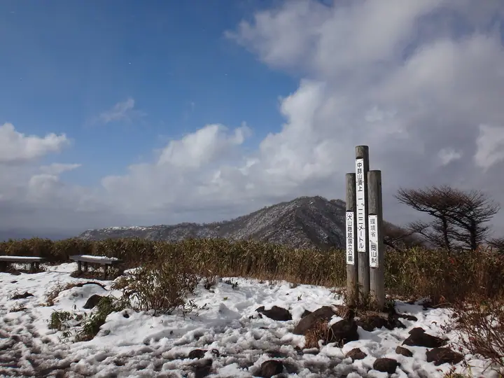
Nakahiruzen is a 1,123.3 m peak straddling Kurayoshi City (Tottori) and Maniwa City (Okayama)—the central summit of the 'Hiruzen Sanza' trio together with Kami- and Shimo-Hiruzen. Its slopes lie within Daisen-Oki National Park, and the peak serves as the middle waypoint on the popular 11 km traverse linking the three Hiruzen summits. Its open grassy ridge looks south over the bucolic Hiruzen Highlands and north to Mt. Daisen. The peak appears in the Okayama Prefecture Hyakumeizan, the Okayama prefectural climbing guide and the Chūgoku Region 100 Mountains.
Mt. Nakahiruzen at a glance
- Weather: The most settled day in the next 7 days is Wed, November 4: clear, gusts up to 7 m/s.
- Route: The shortest is Shimo-Hiruzen to Kami-Hiruzen Three-Peak Ridge Traverse: about 7 h 20 min, 11.3 km, about 1,160 m of climbing.
Mt. Nakahiruzen weather (hourly, 14 days)
Sunrise today 06:28, sunset 17:10
| Tue, 11/3 | Wed, 11/4 | Thu, 11/5 | Fri, 11/6 | Sat, 11/7 | Sun, 11/8 | Mon, 11/9 | Tue, 11/10 | Wed, 11/11 | Thu, 11/12 | Fri, 11/13 | Sat, 11/14 | Sun, 11/15 | Mon, 11/16 | Tue, 11/17 | |||||||||||||||||||||||||||||||||||||||||||||||||||||||||||||||||||||||
|---|---|---|---|---|---|---|---|---|---|---|---|---|---|---|---|---|---|---|---|---|---|---|---|---|---|---|---|---|---|---|---|---|---|---|---|---|---|---|---|---|---|---|---|---|---|---|---|---|---|---|---|---|---|---|---|---|---|---|---|---|---|---|---|---|---|---|---|---|---|---|---|---|---|---|---|---|---|---|---|---|---|---|---|---|---|
| Japan time | 15 | 17 | 19 | 21 | 23 | 1 | 3 | 5 | 7 | 9 | 11 | 13 | 15 | 18 | 21 | 0 | 3 | 6 | 9 | 12 | 15 | 18 | 21 | 0 | 3 | 6 | 9 | 12 | 15 | 18 | 21 | 0 | 3 | 6 | 9 | 12 | 15 | 18 | 21 | 0 | 3 | 6 | 9 | 12 | 15 | 18 | 21 | 0 | 3 | 6 | 9 | 15 | 21 | 3 | 9 | 15 | 21 | 3 | 9 | 15 | 21 | 3 | 9 | 15 | 21 | 3 | 9 | 15 | 21 | 3 | 9 | 15 | 21 | 3 | 9 | 15 | 21 | 3 | 9 | 15 | 21 | 3 | 9 | 15 | |
  | |   | | |   | |   |   |   | | | | | | |   |   | |   | | | | | | |   | | | | | | | |   | | | | | | | | | | | | | | | | | |   | | | | | | | | | |  | | | | | | | | | | | | | | | | | | | | | | ||
| Temperature | °C | 9° | 7° | 6° | 6° | 6° | 5° | 5° | 4° | 4° | 8° | 11° | 11° | 10° | 6° | 7° | 7° | 7° | 8° | 11° | 12° | 11° | 10° | 9° | 9° | 9° | 8° | 10° | 11° | 9° | 6° | 5° | 5° | 4° | 3° | 5° | 6° | 6° | 4° | 3° | 1° | 0° | 0° | 7° | 8° | 7° | 5° | 4° | 4° | 4° | 3° | 7° | 7° | 2° | 1° | 6° | 6° | 3° | 1° | 3° | 4° | 3° | 1° | 5° | 9° | 3° | 4° | 4° | 5° | 2° | 1° | 7° | 11° | 4° | 6° | 9° | 9° | 9° | 9° | 9° | 6° | 3° | 2° | 4° | 4° |
| Precipitation | mm | 1.3 | 0.7 | 0.5 | 0.4 | 0.2 | 0.6 | 0.9 | 3.9 | 3.7 | 3.2 | 10 | 0.7 | 0.2 | 0.3 | 0.6 | 0.7 | 0.4 | 0.2 | 2.5 | 0.3 | 0.6 | 2.2 | 0.7 | 1.7 | 0.7 | 1.7 | 0.9 | 1.2 | 3.9 | 1.0 | 6 | 18 | 0.8 | 8 | 14 | 10 | 0.5 | 0.1 | ||||||||||||||||||||||||||||||||||||||||||||||
| New snow | cm | ||||||||||||||||||||||||||||||||||||||||||||||||||||||||||||||||||||||||||||||||||||
| Snow depth | cm | 0 | 0 | 0 | 0 | 0 | 0 | 0 | 0 | 0 | 0 | 0 | 0 | 0 | 0 | 0 | 0 | 0 | 0 | 0 | 0 | 0 | 0 | 0 | 0 | 0 | 0 | 0 | 0 | 0 | 0 | 0 | 0 | 0 | 0 | 0 | 0 | 0 | 0 | 0 | 0 | 0 | 0 | 0 | 0 | 0 | 0 | 0 | 0 | 0 | 0 | 0 | 0 | 0 | 0 | 0 | 0 | 0 | 0 | 0 | 0 | 0 | 0 | 0 | 0 | 0 | 0 | 0 | 0 | 0 | 0 | 0 | 0 | 0 | 0 | 0 | 0 | 0 | 0 | 0 | 0 | 0 | 0 | 0 | 0 |
| Wind | m/s | 2 | 0 | 1 | 1 | 1 | 1 | 1 | 1 | 1 | 2 | 2 | 2 | 2 | 1 | 2 | 1 | 2 | 1 | 1 | 1 | 1 | 2 | 1 | 1 | 1 | 1 | 2 | 5 | 5 | 3 | 4 | 4 | 5 | 5 | 6 | 5 | 5 | 2 | 1 | 1 | 1 | 1 | 1 | 3 | 3 | 1 | 1 | 1 | 1 | 1 | 2 | 2 | 2 | 1 | 2 | 4 | 5 | 6 | 4 | 3 | 1 | 1 | 1 | 4 | 1 | 2 | 3 | 3 | 1 | 1 | 1 | 1 | 3 | 3 | 4 | 7 | 2 | 2 | 3 | 4 | 3 | 2 | 2 | 1 |
| Wind gusts | m/s | 7 | 6 | 3 | 3 | 2 | 3 | 3 | 3 | 3 | 5 | 7 | 7 | 7 | 6 | 6 | 8 | 6 | 5 | 4 | 4 | 5 | 6 | 6 | 7 | 6 | 7 | 8 | 14 | 14 | 12 | 12 | 12 | 12 | 13 | 15 | 15 | 14 | 13 | 6 | 4 | 4 | 4 | 5 | 9 | 9 | 6 | 3 | 3 | 4 | 4 | 6 | 9 | 8 | 5 | 8 | 13 | 13 | 17 | 14 | 11 | 9 | 4 | 5 | 10 | 10 | 7 | 9 | 10 | 9 | 4 | 4 | 6 | 7 | 9 | 11 | 18 | 18 | 10 | 9 | 11 | 11 | 8 | 6 | 6 |
| Wind dir. | ↓ | ↓ | ↓ | ↓ | ↓ | ↓ | ↓ | ↓ | ↓ | ↓ | ↓ | ↓ | ↓ | ↓ | ↓ | ↓ | ↓ | ↓ | ↓ | ↓ | ↓ | ↓ | ↓ | ↓ | ↓ | ↓ | ↓ | ↓ | ↓ | ↓ | ↓ | ↓ | ↓ | ↓ | ↓ | ↓ | ↓ | ↓ | ↓ | ↓ | ↓ | ↓ | ↓ | ↓ | ↓ | ↓ | ↓ | ↓ | ↓ | ↓ | ↓ | ↓ | ↓ | ↓ | ↓ | ↓ | ↓ | ↓ | ↓ | ↓ | ↓ | ↓ | ↓ | ↓ | ↓ | ↓ | ↓ | ↓ | ↓ | ↓ | ↓ | ↓ | ↓ | ↓ | ↓ | ↓ | ↓ | ↓ | ↓ | ↓ | ↓ | ↓ | ↓ | ↓ | |
Mt. Nakahiruzen hiking routes
- Shimo-Hiruzen to Kami-Hiruzen Three-Peak Ridge Traverse 11.3 km · Ascent 1,159 m parking → 上蒜山登山口駐車場
Hiking times are estimates calculated from the terrain.
Huts, campsites and lodging near Mt. Nakahiruzen
Mountain huts
- 中蒜山避難小屋
- だんだん村
Campsites
- ひるぜん塩釜キャンプ場
- 中蒜山オートキャンプ場
- 蒜山高原キャンプ場
Lodging
- ひるぜん塩釜キャンピングヴィレッジ
- 蒜山倶楽部 Nadja
Lists that include Mt. Nakahiruzen
Mt. Nakahiruzen facts
- Elevation
- 1,123 m
- Location
- Maniwa, Okayama / Kurayoshi, Tottori
35.319892, 133.675568 - National Park
- 大山隠岐国立公園
- Website
- www.env.go.jp
- Trail Map
- www.env.go.jp (PDF)
- Access Information
- www.maniwa.or.jp
- Wikipedia
- ja.wikipedia.org