
Mt. Jizō
地蔵ヶ岳
Hokuto, Yamanashi · Elevation 2,764 m
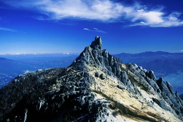
Mt. Jizō is the northernmost of the three Hōō Sanzan peaks in the northern Akaishi Mountains (Southern Alps), at 2,764 m. An 18-metre granite "Obelisk" pinnacle crowns the summit, a long-revered symbol of mountain worship. Below it lies the "Sai-no-Kawara" sand-and-stones plateau bearing carved Jizō figures, and local legend says that carrying a Jizō home, praying for a child and later returning two figures will bring a healthy birth. Within South Alps National Park, the summit is reached in about an hour from Hōō-goya hut, with bus access from Nirasaki Station via Aoki or Gozaishi Onsen. The peak forms part of the Nihon Hyaku-meizan "Hōō-san" and is also listed among the Hyaku-kōzan.
Mt. Jizō at a glance
- Weather: The most settled day in the next 7 days is Sun, November 8: clear, gusts up to 9 m/s. Sat, Nov 7: strong wind (gusts up to 17 m/s).
- Route: The shortest is Phoenix Mountains: Mount Yakushi, Mount Kannon, and Mount Jizō from Yashajin Pass Out-and-Back: about 15 h 33 min, 24.4 km, about 2,320 m of climbing.
Mt. Jizō weather (hourly, 14 days)
Sunrise today 06:10, sunset 16:51
| Tue, 11/3 | Wed, 11/4 | Thu, 11/5 | Fri, 11/6 | Sat, 11/7 | Sun, 11/8 | Mon, 11/9 | Tue, 11/10 | Wed, 11/11 | Thu, 11/12 | Fri, 11/13 | Sat, 11/14 | Sun, 11/15 | Mon, 11/16 | Tue, 11/17 | |||||||||||||||||||||||||||||||||||||||||||||||||||||||||||||||||||||||
|---|---|---|---|---|---|---|---|---|---|---|---|---|---|---|---|---|---|---|---|---|---|---|---|---|---|---|---|---|---|---|---|---|---|---|---|---|---|---|---|---|---|---|---|---|---|---|---|---|---|---|---|---|---|---|---|---|---|---|---|---|---|---|---|---|---|---|---|---|---|---|---|---|---|---|---|---|---|---|---|---|---|---|---|---|---|
| Japan time | 15 | 17 | 19 | 21 | 23 | 1 | 3 | 5 | 7 | 9 | 11 | 13 | 15 | 18 | 21 | 0 | 3 | 6 | 9 | 12 | 15 | 18 | 21 | 0 | 3 | 6 | 9 | 12 | 15 | 18 | 21 | 0 | 3 | 6 | 9 | 12 | 15 | 18 | 21 | 0 | 3 | 6 | 9 | 12 | 15 | 18 | 21 | 0 | 3 | 6 | 9 | 15 | 21 | 3 | 9 | 15 | 21 | 3 | 9 | 15 | 21 | 3 | 9 | 15 | 21 | 3 | 9 | 15 | 21 | 3 | 9 | 15 | 21 | 3 | 9 | 15 | 21 | 3 | 9 | 15 | 21 | 3 | 9 | 15 | |
  |   | | |   | |  | | | | |   |   |   | | | | | | |   | | |  | |   | |  | | | | | |   | | | | | | | | | | | | | | | | | | |   |   | | | | |   | | |  | | | | | | | | | | | | | | | | | |   | | | | | ||
| Temperature | °C | 4° | -2° | -4° | -5° | -6° | -6° | -6° | -6° | -4° | 2° | 4° | 5° | 3° | 0° | -1° | -1° | -1° | 0° | 4° | 7° | 4° | 2° | 0° | -1° | 1° | 1° | 4° | 8° | 7° | -1° | -3° | -5° | -7° | -8° | -2° | 1° | 0° | -7° | -9° | -8° | -7° | -7° | 1° | 3° | 2° | -5° | -4° | -3° | -4° | -4° | -1° | 2° | -5° | -8° | -2° | -1° | -5° | -7° | -6° | -3° | -8° | -7° | -1° | 0° | -6° | -6° | -2° | 0° | -7° | -6° | 1° | 2° | -7° | -7° | 2° | 2° | 0° | 0° | 5° | 4° | -5° | -6° | -1° | 1° |
| Precipitation | mm | 0.4 | 0.1 | 5 | 10 | 6 | 1.6 | 0.4 | 0.2 | 0.1 | 8 | 14 | 0.1 | ||||||||||||||||||||||||||||||||||||||||||||||||||||||||||||||||||||||||
| New snow | cm | 0.1 | |||||||||||||||||||||||||||||||||||||||||||||||||||||||||||||||||||||||||||||||||||
| Snow depth | cm | 0 | 0 | 0 | 0 | 0 | 0 | 0 | 0 | 0 | 0 | 0 | 0 | 0 | 0 | 0 | 0 | 0 | 0 | 0 | 0 | 0 | 0 | 0 | 0 | 0 | 0 | 0 | 0 | 0 | 0 | 0 | 0 | 0 | 0 | 0 | 0 | 0 | 0 | 0 | 0 | 0 | 0 | 0 | 0 | 0 | 0 | 0 | 0 | 0 | 0 | 0 | 0 | 0 | 0 | 0 | 0 | 0 | 0 | 0 | 0 | 0 | 0 | 0 | 0 | 0 | 0 | 0 | 0 | 0 | 0 | 0 | 0 | 0 | 0 | 0 | 0 | 0 | 0 | 0 | 0 | 0 | 0 | 0 | 0 |
| Wind | m/s | 1 | 0 | 1 | 2 | 1 | 1 | 1 | 1 | 1 | 1 | 1 | 0 | 1 | 2 | 2 | 3 | 2 | 1 | 1 | 1 | 2 | 1 | 2 | 2 | 3 | 2 | 2 | 3 | 3 | 3 | 2 | 2 | 3 | 3 | 3 | 4 | 3 | 2 | 2 | 2 | 2 | 1 | 0 | 1 | 1 | 1 | 2 | 2 | 2 | 2 | 2 | 1 | 2 | 2 | 1 | 3 | 3 | 4 | 4 | 2 | 1 | 1 | 2 | 2 | 1 | 2 | 2 | 1 | 1 | 1 | 1 | 1 | 2 | 2 | 2 | 1 | 2 | 2 | 2 | 4 | 1 | 1 | 0 | 1 |
| Wind gusts | m/s | 8 | 7 | 8 | 9 | 9 | 9 | 9 | 8 | 8 | 7 | 7 | 6 | 6 | 10 | 11 | 13 | 16 | 14 | 8 | 9 | 13 | 12 | 11 | 12 | 15 | 15 | 13 | 14 | 14 | 14 | 15 | 15 | 16 | 15 | 16 | 17 | 17 | 13 | 12 | 11 | 11 | 10 | 9 | 8 | 9 | 8 | 11 | 13 | 13 | 13 | 13 | 14 | 8 | 10 | 11 | 14 | 14 | 19 | 20 | 18 | 12 | 8 | 10 | 13 | 11 | 9 | 11 | 11 | 8 | 7 | 7 | 8 | 9 | 11 | 11 | 14 | 16 | 19 | 15 | 15 | 14 | 8 | 6 | 8 |
| Wind dir. | ↓ | ↓ | ↓ | ↓ | ↓ | ↓ | ↓ | ↓ | ↓ | ↓ | ↓ | ↓ | ↓ | ↓ | ↓ | ↓ | ↓ | ↓ | ↓ | ↓ | ↓ | ↓ | ↓ | ↓ | ↓ | ↓ | ↓ | ↓ | ↓ | ↓ | ↓ | ↓ | ↓ | ↓ | ↓ | ↓ | ↓ | ↓ | ↓ | ↓ | ↓ | ↓ | ↓ | ↓ | ↓ | ↓ | ↓ | ↓ | ↓ | ↓ | ↓ | ↓ | ↓ | ↓ | ↓ | ↓ | ↓ | ↓ | ↓ | ↓ | ↓ | ↓ | ↓ | ↓ | ↓ | ↓ | ↓ | ↓ | ↓ | ↓ | ↓ | ↓ | ↓ | ↓ | ↓ | ↓ | ↓ | ↓ | ↓ | ↓ | ↓ | ↓ | ↓ | ↓ | |
Mt. Jizō hiking routes
Hiking times are estimates calculated from the terrain.
Huts, campsites and lodging near Mt. Jizō
Mountain huts
- Houou Hut 2026: open May 29–November 7 · reservation required
- Winter Hut
- Yakushi-dake Goya 2026: open June 6–November 2 · reservation required · sleeps 20
- 広河原山荘 2026: open June 26–November 3 · reservation required · sleeps 101
- 早川尾根小屋 2026: open July 15–October 5 · reservation required · sleeps 20
Campsites
- 鳳凰小屋テント場
- 青木鉱泉キャンプ場
Lodging
- Aoki Kosen
Lists that include Mt. Jizō
Japan's 100 Highest Mountains · Hōō Sanzan · Elevations of 1003 Mountains of Japan · 1000 Mountains of Japan
Mt. Jizō facts
- Also known as
- 地蔵岳
- Elevation
- 2,764 m
- Location
- Hokuto, Yamanashi
35.712092, 138.298715 - National Park
- 南アルプス国立公園
- Website
- www.city.nirasaki.lg.jp
- Trail Map
- www.nirasaki-kankou.jp (PDF)
- Access Information
- www.nirasaki-kankou.jp
- Wikipedia
- ja.wikipedia.org