
Mount Aino
間ノ岳
Minami-Alps, Yamanashi · Elevation 3,190 m
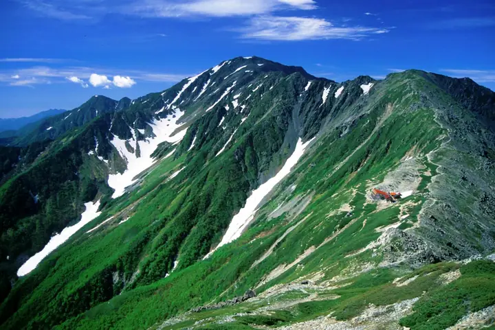
Mount Aino is a 3,190 m peak on the boundary between Minami-Alps City and Hayakawa Town in Yamanashi and Shizuoka City, tied with Mount Okuhotaka as Japan's third-highest summit. As the central peak of the Shirane Sanzan in the Akaishi Mountains (Southern Alps), it lies between Mount Kita and Mount Nōtori, and is listed in Fukada Kyūya's Hyakumeizan, the Yamanashi Hyakumeizan, and the Hyakkōzan. Within Minami-Alps National Park, the mountain is distinguished by its broad, gently rolling summit ridge, with east-facing cirques and multi-tiered ridges at the headwaters of the Ōi River that record the region's geological history. The standard route ascends from Hirogawara via Mount Kita and the Kitadake-Sansō hut, and the classic Shirane Sanzan traverse continues south over Mount Nōtori before descending to Naradah via the Daimon-zawa.
Mount Aino at a glance
- Weather: The most settled day in the next 7 days is Sun, November 8: clear, gusts up to 10 m/s. Sat, Nov 7: strong wind (gusts up to 16 m/s).
- Route: The shortest is Mount Kita and Mount Aino from Hirogawara: about 14 h 4 min, 20.1 km, about 2,490 m of climbing.
Mount Aino weather (hourly, 14 days)
Sunrise today 06:10, sunset 16:51
| Tue, 11/3 | Wed, 11/4 | Thu, 11/5 | Fri, 11/6 | Sat, 11/7 | Sun, 11/8 | Mon, 11/9 | Tue, 11/10 | Wed, 11/11 | Thu, 11/12 | Fri, 11/13 | Sat, 11/14 | Sun, 11/15 | Mon, 11/16 | Tue, 11/17 | |||||||||||||||||||||||||||||||||||||||||||||||||||||||||||||||||||||||
|---|---|---|---|---|---|---|---|---|---|---|---|---|---|---|---|---|---|---|---|---|---|---|---|---|---|---|---|---|---|---|---|---|---|---|---|---|---|---|---|---|---|---|---|---|---|---|---|---|---|---|---|---|---|---|---|---|---|---|---|---|---|---|---|---|---|---|---|---|---|---|---|---|---|---|---|---|---|---|---|---|---|---|---|---|---|
| Japan time | 15 | 17 | 19 | 21 | 23 | 1 | 3 | 5 | 7 | 9 | 11 | 13 | 15 | 18 | 21 | 0 | 3 | 6 | 9 | 12 | 15 | 18 | 21 | 0 | 3 | 6 | 9 | 12 | 15 | 18 | 21 | 0 | 3 | 6 | 9 | 12 | 15 | 18 | 21 | 0 | 3 | 6 | 9 | 12 | 15 | 18 | 21 | 0 | 3 | 6 | 9 | 15 | 21 | 3 | 9 | 15 | 21 | 3 | 9 | 15 | 21 | 3 | 9 | 15 | 21 | 3 | 9 | 15 | 21 | 3 | 9 | 15 | 21 | 3 | 9 | 15 | 21 | 3 | 9 | 15 | 21 | 3 | 9 | 15 | |
 |   | |   | | | | |   |   | |   |   |   | | | | | | |   |   | | |   |   | | | |  | | | | | | | | | | | | | | | | | |   | | | | | |   | | | | | | |   |  | | | | | | | | | | | | | | | | |   | | | | | | ||
| Temperature | °C | 1° | -5° | -7° | -8° | -9° | -8° | -7° | -6° | -5° | 0° | 2° | 3° | 0° | -2° | -2° | -2° | -2° | 0° | 3° | 6° | 2° | 0° | -2° | -2° | -1° | -1° | 1° | 5° | 4° | -3° | -5° | -8° | -10° | -11° | -5° | -1° | -2° | -10° | -10° | -10° | -9° | -8° | -1° | 1° | -1° | -7° | -6° | -6° | -6° | -7° | -3° | -2° | -9° | -11° | -5° | -4° | -7° | -10° | -8° | -4° | -9° | -8° | -4° | -3° | -9° | -8° | -4° | -2° | -8° | -7° | -1° | -1° | -9° | -8° | 0° | 0° | -2° | -2° | 2° | 3° | -6° | -6° | -3° | -2° |
| Precipitation | mm | 0.3 | 0.9 | 0.3 | 6 | 11 | 6 | 0.1 | 1.3 | 0.1 | 0.7 | 0.1 | 0.1 | 10 | 16 | 0.3 | |||||||||||||||||||||||||||||||||||||||||||||||||||||||||||||||||||||
| New snow | cm | <.1 | <.1 | <.1 | <.1 | ||||||||||||||||||||||||||||||||||||||||||||||||||||||||||||||||||||||||||||||||
| Snow depth | cm | 0 | 0 | 0 | 0 | 0 | 0 | 0 | 0 | 0 | 0 | 0 | 0 | 0 | 0 | 0 | 0 | 0 | 0 | 0 | 0 | 0 | 0 | 0 | 0 | 0 | 0 | 0 | 0 | 0 | 0 | 0 | 0 | 0 | 0 | 0 | 0 | 0 | 0 | 0 | 0 | 0 | 0 | 0 | 0 | 0 | 0 | 0 | 0 | 0 | 0 | 0 | 0 | 0 | 0 | 0 | 0 | 0 | 0 | 0 | 0 | 0 | 0 | 0 | 0 | 0 | 0 | 0 | 0 | 0 | 0 | 0 | 0 | 0 | 0 | 0 | 0 | 0 | 0 | 0 | 0 | 0 | 0 | 0 | 0 |
| Wind | m/s | 1 | 0 | 1 | 1 | 1 | 1 | 1 | 1 | 1 | 1 | 1 | 1 | 1 | 2 | 2 | 2 | 2 | 1 | 0 | 1 | 2 | 1 | 1 | 1 | 2 | 1 | 2 | 2 | 2 | 2 | 2 | 2 | 3 | 2 | 3 | 2 | 2 | 1 | 1 | 1 | 1 | 1 | 1 | 1 | 1 | 0 | 1 | 2 | 1 | 1 | 2 | 1 | 0 | 1 | 1 | 2 | 2 | 3 | 3 | 1 | 0 | 1 | 2 | 2 | 0 | 1 | 1 | 0 | 1 | 1 | 1 | 1 | 1 | 1 | 2 | 2 | 2 | 2 | 2 | 2 | 1 | 1 | 1 | 1 |
| Wind gusts | m/s | 9 | 8 | 7 | 8 | 8 | 9 | 8 | 8 | 8 | 8 | 9 | 8 | 8 | 10 | 11 | 13 | 15 | 14 | 9 | 9 | 14 | 13 | 11 | 12 | 14 | 14 | 12 | 13 | 13 | 12 | 14 | 15 | 16 | 16 | 16 | 16 | 14 | 13 | 11 | 11 | 11 | 10 | 9 | 10 | 10 | 8 | 11 | 12 | 12 | 12 | 12 | 13 | 8 | 9 | 11 | 13 | 12 | 18 | 19 | 18 | 9 | 8 | 10 | 11 | 10 | 7 | 10 | 10 | 7 | 6 | 6 | 8 | 8 | 10 | 11 | 14 | 17 | 17 | 15 | 12 | 11 | 7 | 7 | 8 |
| Wind dir. | ↓ | ↓ | ↓ | ↓ | ↓ | ↓ | ↓ | ↓ | ↓ | ↓ | ↓ | ↓ | ↓ | ↓ | ↓ | ↓ | ↓ | ↓ | ↓ | ↓ | ↓ | ↓ | ↓ | ↓ | ↓ | ↓ | ↓ | ↓ | ↓ | ↓ | ↓ | ↓ | ↓ | ↓ | ↓ | ↓ | ↓ | ↓ | ↓ | ↓ | ↓ | ↓ | ↓ | ↓ | ↓ | ↓ | ↓ | ↓ | ↓ | ↓ | ↓ | ↓ | ↓ | ↓ | ↓ | ↓ | ↓ | ↓ | ↓ | ↓ | ↓ | ↓ | ↓ | ↓ | ↓ | ↓ | ↓ | ↓ | ↓ | ↓ | ↓ | ↓ | ↓ | ↓ | ↓ | ↓ | ↓ | ↓ | ↓ | ↓ | ↓ | ↓ | ↓ | ↓ | |
Mount Aino hiking routes
Hiking times are estimates calculated from the terrain.
Huts, campsites and lodging near Mount Aino
Mountain huts
- Notori Hut reservation required
- Kita-dake Sanso 2026: open June 15–November 5 · reservation required · sleeps 80
- Kumanodaira Hut 2026: open July 11–September 22 · reservation required · sleeps 30
- Kita-dake Kata-no-koya 2026: open June 26–October 25 · reservation required · sleeps 80
- Ryōmata Hut 2026: open June 1–October 31 · sleeps 30
Campsites
- Notori Campground
- 北岳山荘テント場
- 北岳肩の小屋テント場
Lists that include Mount Aino
100 Famous Japanese Mountains · Japan 200 Famous Mountains · Japan's 300 Famous Mountains · Japan's 100 Highest Mountains · Japan's 3000 m Peaks · Koshinetsu 100 Famous Mountains · Yamanashi 100 Famous Mountains · 100 Mountains of Shizuoka · Shirane 3 Peaks · Elevations of 1003 Mountains of Japan · 1000 Mountains of Japan
Mount Aino facts
- Elevation
- 3,190 m
- Location
- Minami-Alps, Yamanashi
35.646037, 138.228350 - National Park
- 南アルプス国立公園
- Trail Map
- www.pref.yamanashi.jp (PDF)
- Access Information
- www.city.minami-alps.yamanashi.jp
- Wikipedia
- ja.wikipedia.org