
Mount Shiomi
塩見岳
Shizuoka, Shizuoka · Elevation 3,052 m
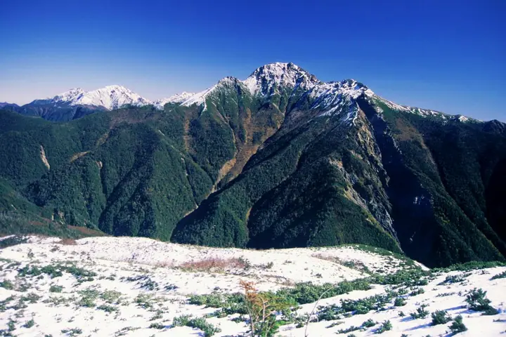
A 3,052-meter (east summit) twin-peaked mountain on the spine of the Southern Japanese Alps, marking the prefectural boundary between Ina City and Ohshika Village in Nagano and Shizuoka City in Shizuoka. The two summits—east at 3,052 m and west at 3,047 m—rise as rocky horns above the otherwise gentle ridges of the range, earning the peak its nickname "the navel of the Southern Alps," and the crest lies within a special protection zone of Minami Alps National Park. The standard ascent runs from the Torigura trailhead on the Nagano side over Sanpuku Pass (claimed as Japan's highest pass) and on to Shiomi Hut. The peak is enshrined in Hyakumeizan and numerous other named-mountain selections.
Mount Shiomi at a glance
- Weather: The most settled day in the next 7 days is Sun, November 8: clear, gusts up to 9 m/s.
- Route: The shortest is Mount Shiomi Out-and-Back via Sanpuku Pass from Torikura Trailhead: about 14 h 43 min, 25.3 km, about 2,180 m of climbing.
Mount Shiomi weather (hourly, 14 days)
Sunrise today 06:10, sunset 16:52
| Tue, 11/3 | Wed, 11/4 | Thu, 11/5 | Fri, 11/6 | Sat, 11/7 | Sun, 11/8 | Mon, 11/9 | Tue, 11/10 | Wed, 11/11 | Thu, 11/12 | Fri, 11/13 | Sat, 11/14 | Sun, 11/15 | Mon, 11/16 | Tue, 11/17 | |||||||||||||||||||||||||||||||||||||||||||||||||||||||||||||||||||||||
|---|---|---|---|---|---|---|---|---|---|---|---|---|---|---|---|---|---|---|---|---|---|---|---|---|---|---|---|---|---|---|---|---|---|---|---|---|---|---|---|---|---|---|---|---|---|---|---|---|---|---|---|---|---|---|---|---|---|---|---|---|---|---|---|---|---|---|---|---|---|---|---|---|---|---|---|---|---|---|---|---|---|---|---|---|---|
| Japan time | 15 | 17 | 19 | 21 | 23 | 1 | 3 | 5 | 7 | 9 | 11 | 13 | 15 | 18 | 21 | 0 | 3 | 6 | 9 | 12 | 15 | 18 | 21 | 0 | 3 | 6 | 9 | 12 | 15 | 18 | 21 | 0 | 3 | 6 | 9 | 12 | 15 | 18 | 21 | 0 | 3 | 6 | 9 | 12 | 15 | 18 | 21 | 0 | 3 | 6 | 9 | 15 | 21 | 3 | 9 | 15 | 21 | 3 | 9 | 15 | 21 | 3 | 9 | 15 | 21 | 3 | 9 | 15 | 21 | 3 | 9 | 15 | 21 | 3 | 9 | 15 | 21 | 3 | 9 | 15 | 21 | 3 | 9 | 15 | |
 |  |   | | | | | |   |   |   | |   |   | | | | | | |   |  | | |   |   | | | | | | | | | | | | | | | | | | | |   | |   | | | | | | | |   | |   | | |   |  | | | | | | | | | | | | | | | | |   | | | | | | ||
| Temperature | °C | 3° | -3° | -5° | -7° | -7° | -6° | -5° | -5° | -3° | 2° | 4° | 4° | 2° | 0° | 0° | 0° | 0° | 2° | 4° | 7° | 3° | 1° | 0° | 0° | 0° | 0° | 2° | 6° | 3° | -3° | -4° | -6° | -8° | -10° | -4° | 0° | -1° | -9° | -10° | -10° | -8° | -8° | 1° | 2° | 0° | -6° | -5° | -5° | -5° | -5° | -1° | 0° | -8° | -9° | -3° | -3° | -6° | -9° | -6° | -3° | -9° | -8° | -3° | -2° | -8° | -9° | -2° | -1° | -8° | -7° | -1° | 0° | -8° | -6° | 0° | 0° | -1° | -1° | 3° | 4° | -5° | -4° | -2° | -2° |
| Precipitation | mm | 0.3 | 0.8 | 0.2 | 6 | 10 | 6 | 1.3 | 1.5 | 0.2 | 0.1 | 0.3 | 0.4 | 12 | 18 | 0.4 | 0.2 | ||||||||||||||||||||||||||||||||||||||||||||||||||||||||||||||||||||
| New snow | cm | <.1 | <.1 | 0.2 | 0.3 | ||||||||||||||||||||||||||||||||||||||||||||||||||||||||||||||||||||||||||||||||
| Snow depth | cm | 0 | 0 | 0 | 0 | 0 | 0 | 0 | 0 | 0 | 0 | 0 | 0 | 0 | 0 | 0 | 0 | 0 | 0 | 0 | 0 | 0 | 0 | 0 | 0 | 0 | 0 | 0 | 0 | 0 | 0 | 0 | 0 | 0 | 0 | 0 | 0 | 0 | 0 | 0 | 0 | 0 | 0 | 0 | 0 | 0 | 0 | 0 | 0 | 0 | 0 | 0 | 0 | 0 | 0 | 0 | 0 | 0 | 0 | 0 | 0 | 0 | 0 | 0 | 0 | 0 | 0 | 0 | 0 | 0 | 0 | 0 | 0 | 0 | 0 | 0 | 0 | 0 | 0 | 0 | 0 | 0 | 0 | 0 | 0 |
| Wind | m/s | 3 | 1 | 0 | 0 | 1 | 1 | 1 | 1 | 1 | 1 | 2 | 1 | 0 | 1 | 2 | 2 | 2 | 1 | 1 | 2 | 2 | 1 | 1 | 1 | 2 | 1 | 2 | 3 | 2 | 0 | 1 | 1 | 1 | 0 | 2 | 3 | 2 | 1 | 1 | 1 | 0 | 0 | 1 | 2 | 1 | 0 | 1 | 0 | 0 | 0 | 2 | 2 | 1 | 1 | 2 | 4 | 2 | 3 | 3 | 2 | 1 | 1 | 2 | 2 | 0 | 0 | 2 | 2 | 0 | 0 | 1 | 2 | 0 | 1 | 2 | 2 | 2 | 1 | 2 | 3 | 0 | 1 | 1 | 1 |
| Wind gusts | m/s | 9 | 8 | 5 | 4 | 5 | 5 | 5 | 5 | 5 | 6 | 8 | 9 | 7 | 8 | 9 | 13 | 14 | 12 | 7 | 9 | 10 | 10 | 7 | 8 | 10 | 11 | 9 | 12 | 13 | 10 | 8 | 9 | 10 | 10 | 11 | 12 | 12 | 9 | 6 | 6 | 6 | 6 | 7 | 9 | 9 | 6 | 6 | 7 | 7 | 7 | 9 | 11 | 8 | 6 | 8 | 12 | 12 | 16 | 18 | 18 | 10 | 5 | 8 | 10 | 8 | 5 | 11 | 11 | 8 | 5 | 5 | 8 | 7 | 6 | 9 | 12 | 15 | 14 | 11 | 12 | 10 | 5 | 5 | 7 |
| Wind dir. | ↓ | ↓ | ↓ | ↓ | ↓ | ↓ | ↓ | ↓ | ↓ | ↓ | ↓ | ↓ | ↓ | ↓ | ↓ | ↓ | ↓ | ↓ | ↓ | ↓ | ↓ | ↓ | ↓ | ↓ | ↓ | ↓ | ↓ | ↓ | ↓ | ↓ | ↓ | ↓ | ↓ | ↓ | ↓ | ↓ | ↓ | ↓ | ↓ | ↓ | ↓ | ↓ | ↓ | ↓ | ↓ | ↓ | ↓ | ↓ | ↓ | ↓ | ↓ | ↓ | ↓ | ↓ | ↓ | ↓ | ↓ | ↓ | ↓ | ↓ | ↓ | ↓ | ↓ | ↓ | ↓ | ↓ | ↓ | ↓ | ↓ | ↓ | ↓ | ↓ | ↓ | ↓ | ↓ | ↓ | ↓ | ↓ | ↓ | ↓ | ↓ | ↓ | ↓ | ↓ | |
Mount Shiomi hiking routes
Hiking times are estimates calculated from the terrain.
Huts, campsites and lodging near Mount Shiomi
Mountain huts
- Shiomi Hut 2026: open July 1–October 12 · reservation required · sleeps 34
- Sanpuku-toge Hut 2026: open July 5–September 25 · reservation required
- Mount Ogochidake Emergency Shelter 2026: open July 11–August 22 · sleeps 5
Campsites
- Sanpuku-toge Camping Area
Lists that include Mount Shiomi
100 Famous Japanese Mountains · Japan 200 Famous Mountains · Japan's 300 Famous Mountains · Japan's 100 Highest Mountains · New Japan 100 Famous Mountains · Japan's 3000 m Peaks · 100 Famous Hot Spring Mountains · Koshinetsu 100 Famous Mountains · Shinshu 100 Famous Mountains · 100 Mountains of Shizuoka · Shinshu Mountain Cards · Elevations of 1003 Mountains of Japan · 1000 Mountains of Japan
Mount Shiomi facts
- Also known as
- 塩見岳東峰
- Elevation
- 3,052 m
- Location
- Shizuoka, Shizuoka
35.573487, 138.183364 - National Park
- 南アルプス国立公園
- Website
- www.vill.ooshika.nagano.jp
- Wikipedia
- ja.wikipedia.org