
Mount Warusawa
悪沢岳
Shizuoka, Shizuoka · Elevation 3,141 m
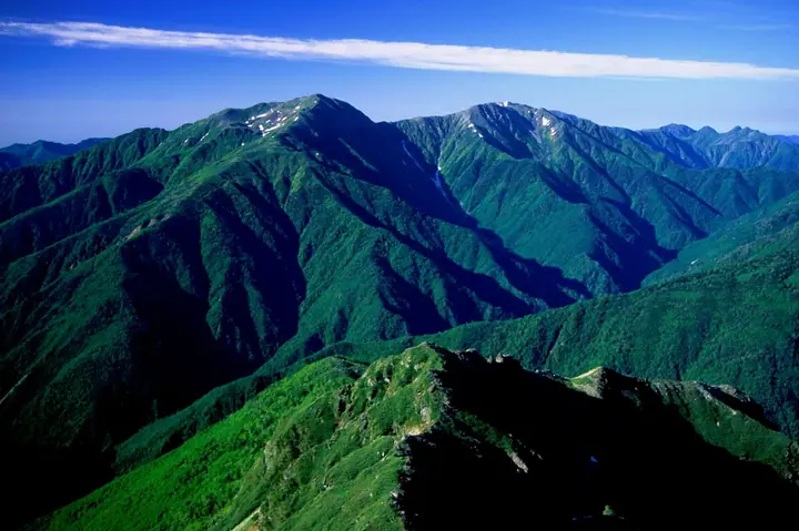
Mount Warusawa (Arakawa-Higashidake, 3,141 m) is a high peak of the Akaishi Mountains in Aoi Ward, Shizuoka City, and forms the "Arakawa Sanzan" trio together with Arakawa Mae-dake and Naka-dake. Lying at the core of Minami-Alps National Park, it ranks sixth-highest in Japan. The peak is reached from the Higashimata-rindo via Sawarajima and the Senmai-goya hut or via the Arakawa-goya hut, with one of Japan's southernmost alpine flower meadows on its slopes. It appears in the 100 Famous Japanese Mountains and the 100 High Mountains of Japan.
Mount Warusawa at a glance
- Weather: The most settled day in the next 7 days is Sun, November 8: clear, gusts up to 9 m/s.
Mount Warusawa weather (hourly, 14 days)
Sunrise today 06:10, sunset 16:52
| Tue, 11/3 | Wed, 11/4 | Thu, 11/5 | Fri, 11/6 | Sat, 11/7 | Sun, 11/8 | Mon, 11/9 | Tue, 11/10 | Wed, 11/11 | Thu, 11/12 | Fri, 11/13 | Sat, 11/14 | Sun, 11/15 | Mon, 11/16 | Tue, 11/17 | |||||||||||||||||||||||||||||||||||||||||||||||||||||||||||||||||||||
|---|---|---|---|---|---|---|---|---|---|---|---|---|---|---|---|---|---|---|---|---|---|---|---|---|---|---|---|---|---|---|---|---|---|---|---|---|---|---|---|---|---|---|---|---|---|---|---|---|---|---|---|---|---|---|---|---|---|---|---|---|---|---|---|---|---|---|---|---|---|---|---|---|---|---|---|---|---|---|---|---|---|---|---|
| Japan time | 21 | 23 | 1 | 3 | 5 | 7 | 9 | 11 | 13 | 15 | 17 | 19 | 21 | 0 | 3 | 6 | 9 | 12 | 15 | 18 | 21 | 0 | 3 | 6 | 9 | 12 | 15 | 18 | 21 | 0 | 3 | 6 | 9 | 12 | 15 | 18 | 21 | 0 | 3 | 6 | 9 | 12 | 15 | 18 | 21 | 0 | 3 | 6 | 9 | 15 | 21 | 3 | 9 | 15 | 21 | 3 | 9 | 15 | 21 | 3 | 9 | 15 | 21 | 3 | 9 | 15 | 21 | 3 | 9 | 15 | 21 | 3 | 9 | 15 | 21 | 3 | 9 | 15 | 21 | 3 | 9 | 15 | |
 | |   | |   |   |   | |   |   |   | |   | | |   |   |   | |  | | |   | |  | | | | | | | | | | | | | | | | | | | | |   | | | | | | | |   | | | | |   |  | | | | | | | | | | | | | | | | | | | | | | | ||
| Temperature | °C | -7° | -7° | -7° | -6° | -6° | -4° | 2° | 3° | 3° | 1° | -1° | -1° | -1° | -1° | -1° | 1° | 4° | 7° | 4° | 0° | 0° | -1° | -1° | -1° | 2° | 5° | 3° | -3° | -5° | -7° | -9° | -11° | -4° | -1° | -2° | -10° | -11° | -10° | -9° | -8° | 0° | 1° | -1° | -6° | -6° | -5° | -5° | -5° | -2° | -1° | -8° | -10° | -4° | -3° | -7° | -10° | -7° | -3° | -10° | -9° | -4° | -3° | -8° | -9° | -3° | -1° | -9° | -8° | -2° | -1° | -8° | -6° | 0° | 0° | -2° | -1° | 2° | 3° | -6° | -5° | -2° | -2° |
| Precipitation | mm | 0.5 | 0.5 | 0.5 | 1.4 | 7 | 9 | 3.0 | 0.4 | 0.2 | 1.5 | 0.2 | 0.1 | 0.3 | 0.4 | 12 | 18 | 0.4 | 0.2 | ||||||||||||||||||||||||||||||||||||||||||||||||||||||||||||||||
| New snow | cm | – | – | <.1 | <.1 | 0.2 | 0.3 | ||||||||||||||||||||||||||||||||||||||||||||||||||||||||||||||||||||||||||||
| Snow depth | cm | 0 | 0 | 0 | 0 | 0 | 0 | 0 | 0 | 0 | 0 | 0 | 0 | 0 | 0 | 0 | 0 | 0 | 0 | 0 | 0 | 0 | 0 | 0 | 0 | 0 | 0 | 0 | 0 | 0 | 0 | 0 | 0 | 0 | 0 | 0 | 0 | 0 | 0 | 0 | 0 | 0 | 0 | 0 | 0 | 0 | 0 | 0 | 0 | 0 | 0 | 0 | 0 | 0 | 0 | 0 | 0 | 0 | 0 | 0 | 0 | 0 | 0 | 0 | 0 | 0 | 0 | 0 | 0 | 0 | 0 | 0 | 0 | 0 | 0 | 0 | 0 | 0 | 0 | 0 | 0 | 0 | 0 |
| Wind | m/s | 0 | 0 | 0 | 1 | 1 | 1 | 1 | 2 | 1 | 1 | 1 | 1 | 2 | 2 | 1 | 0 | 1 | 3 | 1 | 1 | 1 | 1 | 2 | 1 | 2 | 3 | 2 | 0 | 1 | 1 | 1 | 0 | 2 | 3 | 2 | 1 | 1 | 1 | 0 | 0 | 1 | 2 | 1 | 0 | 1 | 0 | 0 | 0 | 2 | 2 | 1 | 1 | 2 | 4 | 2 | 3 | 3 | 2 | 1 | 1 | 2 | 2 | 0 | 0 | 2 | 2 | 0 | 0 | 1 | 2 | 0 | 1 | 2 | 2 | 2 | 1 | 2 | 3 | 0 | 1 | 1 | 1 |
| Wind gusts | m/s | 4 | 5 | 5 | 5 | 5 | 5 | 7 | 8 | 8 | 6 | 6 | 7 | 9 | 13 | 13 | 11 | 7 | 11 | 11 | 10 | 7 | 8 | 10 | 11 | 9 | 12 | 13 | 10 | 8 | 9 | 10 | 10 | 11 | 12 | 12 | 9 | 6 | 6 | 6 | 6 | 7 | 9 | 9 | 6 | 6 | 7 | 7 | 7 | 9 | 11 | 8 | 6 | 8 | 12 | 12 | 16 | 18 | 18 | 10 | 5 | 8 | 10 | 8 | 5 | 11 | 11 | 8 | 5 | 5 | 8 | 7 | 6 | 9 | 12 | 15 | 14 | 11 | 12 | 10 | 5 | 5 | 7 |
| Wind dir. | ↓ | ↓ | ↓ | ↓ | ↓ | ↓ | ↓ | ↓ | ↓ | ↓ | ↓ | ↓ | ↓ | ↓ | ↓ | ↓ | ↓ | ↓ | ↓ | ↓ | ↓ | ↓ | ↓ | ↓ | ↓ | ↓ | ↓ | ↓ | ↓ | ↓ | ↓ | ↓ | ↓ | ↓ | ↓ | ↓ | ↓ | ↓ | ↓ | ↓ | ↓ | ↓ | ↓ | ↓ | ↓ | ↓ | ↓ | ↓ | ↓ | ↓ | ↓ | ↓ | ↓ | ↓ | ↓ | ↓ | ↓ | ↓ | ↓ | ↓ | ↓ | ↓ | ↓ | ↓ | ↓ | ↓ | ↓ | ↓ | ↓ | ↓ | ↓ | ↓ | ↓ | ↓ | ↓ | ↓ | ↓ | ↓ | ↓ | ↓ | ↓ | ↓ | |
Huts, campsites and lodging near Mount Warusawa
Mountain huts
- Arakawa Nakadake Evacuation Hut 2026: open July 11–September 22 · sleeps 5
- 千枚小屋 2026: open July 11–October 11 · reservation required · sleeps 80
- Arakawa Hut 2026: open July 11–October 11 · reservation required · sleeps 50
- Takayamaura Shelter 2026: open July 11–August 22 · sleeps 10
- 赤石小屋 2026: open July 11–October 11 · reservation required · sleeps 50
Campsites
- Arakawa Hut Campsite
Lists that include Mount Warusawa
100 Famous Japanese Mountains · Japan 200 Famous Mountains · Japan's 300 Famous Mountains · Japan's 100 Highest Mountains · Japan's 3000 m Peaks · 100 Mountains of Shizuoka · Elevations of 1003 Mountains of Japan · 1000 Mountains of Japan
Mount Warusawa facts
- Also known as
- 荒川岳 · 東岳 · 荒川東岳
- Elevation
- 3,141 m
- Location
- Shizuoka, Shizuoka
35.500758, 138.182420 - National Park
- 南アルプス国立公園
- Website
- minamialps-shizuokaken.jp
- Trail Map
- nanpusu.jp (PDF)
- Access Information
- nanpusu.jp
- Wikipedia
- ja.wikipedia.org