
Mount Nakashirane
中白根山
Minami-Alps, Yamanashi · Elevation 3,055 m
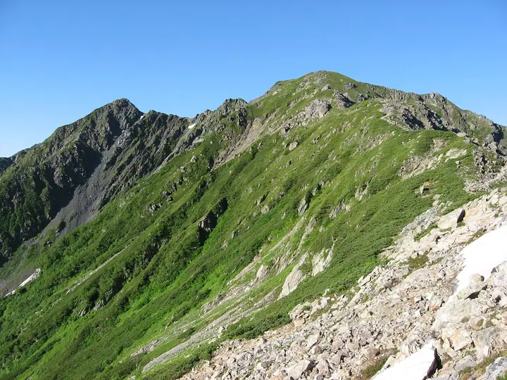
Mount Nakashirane (also known as Naka-Shiramine) is a 3,055 m peak in Minami-Alps City, Yamanashi Prefecture, situated on the main ridge of the northern Akaishi Range (Southern Alps) within Minami-Alps National Park. It rises between Mount Kita (3,193 m) and Mount Aino (3,190 m) along the classic Shirane Sanzan ("Three Peaks of Shirane") traverse, with the 150-person Kitadake-sansō hut at the col immediately to the north serving as the standard staging point for ridge walks above 3,000 m. The peak was named "Naka-Shiramine" in July 1908 by alpinist Kojima Usui after his ascent, and it appears in the "Mountains over 2000 m" list.
Mount Nakashirane at a glance
- Weather: The most settled day in the next 7 days is Sun, November 8: clear, gusts up to 10 m/s. Sat, Nov 7: strong wind (gusts up to 16 m/s).
- Route: The shortest is Mount Kita and Mount Aino from Hirogawara: about 14 h 4 min, 20.1 km, about 2,490 m of climbing.
Mount Nakashirane weather (hourly, 14 days)
Sunrise today 06:10, sunset 16:51
| Tue, 11/3 | Wed, 11/4 | Thu, 11/5 | Fri, 11/6 | Sat, 11/7 | Sun, 11/8 | Mon, 11/9 | Tue, 11/10 | Wed, 11/11 | Thu, 11/12 | Fri, 11/13 | Sat, 11/14 | Sun, 11/15 | Mon, 11/16 | Tue, 11/17 | |||||||||||||||||||||||||||||||||||||||||||||||||||||||||||||||||||||||
|---|---|---|---|---|---|---|---|---|---|---|---|---|---|---|---|---|---|---|---|---|---|---|---|---|---|---|---|---|---|---|---|---|---|---|---|---|---|---|---|---|---|---|---|---|---|---|---|---|---|---|---|---|---|---|---|---|---|---|---|---|---|---|---|---|---|---|---|---|---|---|---|---|---|---|---|---|---|---|---|---|---|---|---|---|---|
| Japan time | 15 | 17 | 19 | 21 | 23 | 1 | 3 | 5 | 7 | 9 | 11 | 13 | 15 | 18 | 21 | 0 | 3 | 6 | 9 | 12 | 15 | 18 | 21 | 0 | 3 | 6 | 9 | 12 | 15 | 18 | 21 | 0 | 3 | 6 | 9 | 12 | 15 | 18 | 21 | 0 | 3 | 6 | 9 | 12 | 15 | 18 | 21 | 0 | 3 | 6 | 9 | 15 | 21 | 3 | 9 | 15 | 21 | 3 | 9 | 15 | 21 | 3 | 9 | 15 | 21 | 3 | 9 | 15 | 21 | 3 | 9 | 15 | 21 | 3 | 9 | 15 | 21 | 3 | 9 | 15 | 21 | 3 | 9 | 15 | |
 |   | |   | | | | |   |   | |   |   |   | | | | | | |   |   | | |   |   | | | |  | | | | | | | | | | | | | | | | | |   | | | | | |   | | | | | | |   |  | | | | | | | | | | | | | | | | |   | | | | | | ||
| Temperature | °C | 2° | -4° | -6° | -7° | -8° | -7° | -6° | -6° | -4° | 1° | 3° | 4° | 1° | -1° | -1° | -1° | -1° | 1° | 4° | 7° | 3° | 1° | -1° | -1° | 0° | -1° | 2° | 6° | 4° | -2° | -4° | -7° | -9° | -11° | -4° | 0° | -1° | -9° | -10° | -9° | -8° | -7° | 0° | 2° | 0° | -7° | -6° | -5° | -5° | -6° | -2° | -1° | -8° | -10° | -4° | -3° | -6° | -9° | -7° | -4° | -9° | -7° | -3° | -2° | -8° | -7° | -3° | -1° | -7° | -6° | 0° | 0° | -8° | -7° | 0° | 0° | -1° | -1° | 3° | 4° | -5° | -5° | -2° | -2° |
| Precipitation | mm | 0.3 | 0.9 | 0.3 | 6 | 11 | 6 | 0.1 | 1.3 | 0.1 | 0.7 | 0.1 | 0.1 | 10 | 16 | 0.3 | |||||||||||||||||||||||||||||||||||||||||||||||||||||||||||||||||||||
| New snow | cm | <.1 | <.1 | <.1 | <.1 | ||||||||||||||||||||||||||||||||||||||||||||||||||||||||||||||||||||||||||||||||
| Snow depth | cm | 0 | 0 | 0 | 0 | 0 | 0 | 0 | 0 | 0 | 0 | 0 | 0 | 0 | 0 | 0 | 0 | 0 | 0 | 0 | 0 | 0 | 0 | 0 | 0 | 0 | 0 | 0 | 0 | 0 | 0 | 0 | 0 | 0 | 0 | 0 | 0 | 0 | 0 | 0 | 0 | 0 | 0 | 0 | 0 | 0 | 0 | 0 | 0 | 0 | 0 | 0 | 0 | 0 | 0 | 0 | 0 | 0 | 0 | 0 | 0 | 0 | 0 | 0 | 0 | 0 | 0 | 0 | 0 | 0 | 0 | 0 | 0 | 0 | 0 | 0 | 0 | 0 | 0 | 0 | 0 | 0 | 0 | 0 | 0 |
| Wind | m/s | 1 | 0 | 1 | 1 | 1 | 1 | 1 | 1 | 1 | 1 | 1 | 1 | 1 | 2 | 2 | 2 | 2 | 1 | 0 | 1 | 2 | 1 | 1 | 1 | 2 | 1 | 2 | 2 | 2 | 2 | 2 | 2 | 3 | 2 | 3 | 2 | 2 | 1 | 1 | 1 | 1 | 1 | 1 | 1 | 1 | 0 | 1 | 2 | 1 | 1 | 2 | 1 | 0 | 1 | 1 | 2 | 2 | 3 | 3 | 1 | 0 | 1 | 2 | 2 | 0 | 1 | 1 | 0 | 1 | 1 | 1 | 1 | 1 | 1 | 2 | 2 | 2 | 2 | 2 | 2 | 1 | 1 | 1 | 1 |
| Wind gusts | m/s | 9 | 8 | 7 | 8 | 8 | 9 | 8 | 8 | 8 | 8 | 9 | 8 | 8 | 10 | 11 | 13 | 15 | 14 | 9 | 9 | 14 | 13 | 11 | 12 | 14 | 14 | 12 | 13 | 13 | 12 | 14 | 15 | 16 | 16 | 16 | 16 | 14 | 13 | 11 | 11 | 11 | 10 | 9 | 10 | 10 | 8 | 11 | 12 | 12 | 12 | 12 | 13 | 8 | 9 | 11 | 13 | 12 | 18 | 19 | 18 | 9 | 8 | 10 | 11 | 10 | 7 | 10 | 10 | 7 | 6 | 6 | 8 | 8 | 10 | 11 | 14 | 17 | 17 | 15 | 12 | 11 | 7 | 7 | 8 |
| Wind dir. | ↓ | ↓ | ↓ | ↓ | ↓ | ↓ | ↓ | ↓ | ↓ | ↓ | ↓ | ↓ | ↓ | ↓ | ↓ | ↓ | ↓ | ↓ | ↓ | ↓ | ↓ | ↓ | ↓ | ↓ | ↓ | ↓ | ↓ | ↓ | ↓ | ↓ | ↓ | ↓ | ↓ | ↓ | ↓ | ↓ | ↓ | ↓ | ↓ | ↓ | ↓ | ↓ | ↓ | ↓ | ↓ | ↓ | ↓ | ↓ | ↓ | ↓ | ↓ | ↓ | ↓ | ↓ | ↓ | ↓ | ↓ | ↓ | ↓ | ↓ | ↓ | ↓ | ↓ | ↓ | ↓ | ↓ | ↓ | ↓ | ↓ | ↓ | ↓ | ↓ | ↓ | ↓ | ↓ | ↓ | ↓ | ↓ | ↓ | ↓ | ↓ | ↓ | ↓ | ↓ | |
Mount Nakashirane hiking routes
Hiking times are estimates calculated from the terrain.
Huts, campsites and lodging near Mount Nakashirane
Mountain huts
- Kita-dake Sanso 2026: open June 15–November 5 · reservation required · sleeps 80
- Kita-dake Kata-no-koya 2026: open June 26–October 25 · reservation required · sleeps 80
- Ryōmata Hut 2026: open June 1–October 31 · sleeps 30
- Notori Hut reservation required
- Kumanodaira Hut 2026: open July 11–September 22 · reservation required · sleeps 30
Campsites
- 北岳山荘テント場
- 北岳肩の小屋テント場
- Notori Campground
Mount Nakashirane facts
- Also known as
- 中白峰
- Elevation
- 3,055 m
- Location
- Minami-Alps, Yamanashi
35.658621, 138.228258 - National Park
- 南アルプス国立公園
- Trail Map
- www.city.minami-alps.yamanashi.jp
- Access Information
- hayakawakankou.jp
- Wikipedia
- ja.wikipedia.org