
Mount Senjō
仙丈ヶ岳
Ina, Nagano / Minami-Alps, Yamanashi · Elevation 3,033 m
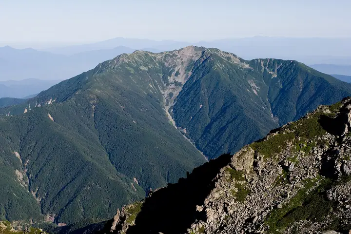
Mount Senjō is a 3,033 m peak on the boundary between Minami-Alps City in Yamanashi and Ina City in Nagano, known as the "Queen of the Southern Alps" in the northern Akaishi Mountains. Listed in Fukada Kyūya's Hyakumeizan, the Hana-no-Hyakumeizan, and the Hyakkōzan, it lies within Minami-Alps National Park. Its smooth, rounded silhouette holds three glacial cirques — Yabusawa, Daisenjō, and Shōsenjō — that bloom with abundant alpine flora in summer, while the summit offers a sweeping panorama of Mount Fuji, the main Southern Alps ridge, the Yatsugatake, Central Alps, and Northern Alps. The standard route reaches Kitazawa-tōge by the Minami Alps Forest Road shuttle bus and ascends the Shōsenjō Ridge to the summit, often combined with the Yabusawa branch as a loop.
Mount Senjō at a glance
- Weather: The most settled day in the next 7 days is Wed, November 4: clear, gusts up to 7 m/s.
- Route: The shortest is Mount Ko-Senjo and Mount Senjo Loop from Kitazawa Pass: about 6 h 28 min, 9.3 km, about 1,130 m of climbing.
Mount Senjō weather (hourly, 14 days)
Sunrise today 06:10, sunset 16:51
| Tue, 11/3 | Wed, 11/4 | Thu, 11/5 | Fri, 11/6 | Sat, 11/7 | Sun, 11/8 | Mon, 11/9 | Tue, 11/10 | Wed, 11/11 | Thu, 11/12 | Fri, 11/13 | Sat, 11/14 | Sun, 11/15 | Mon, 11/16 | Tue, 11/17 | |||||||||||||||||||||||||||||||||||||||||||||||||||||||||||||||||||||||
|---|---|---|---|---|---|---|---|---|---|---|---|---|---|---|---|---|---|---|---|---|---|---|---|---|---|---|---|---|---|---|---|---|---|---|---|---|---|---|---|---|---|---|---|---|---|---|---|---|---|---|---|---|---|---|---|---|---|---|---|---|---|---|---|---|---|---|---|---|---|---|---|---|---|---|---|---|---|---|---|---|---|---|---|---|---|
| Japan time | 15 | 17 | 19 | 21 | 23 | 1 | 3 | 5 | 7 | 9 | 11 | 13 | 15 | 18 | 21 | 0 | 3 | 6 | 9 | 12 | 15 | 18 | 21 | 0 | 3 | 6 | 9 | 12 | 15 | 18 | 21 | 0 | 3 | 6 | 9 | 12 | 15 | 18 | 21 | 0 | 3 | 6 | 9 | 12 | 15 | 18 | 21 | 0 | 3 | 6 | 9 | 15 | 21 | 3 | 9 | 15 | 21 | 3 | 9 | 15 | 21 | 3 | 9 | 15 | 21 | 3 | 9 | 15 | 21 | 3 | 9 | 15 | 21 | 3 | 9 | 15 | 21 | 3 | 9 | 15 | 21 | 3 | 9 | 15 | |
 |   | | |   | | | |   | | | |   |   | |   | |   |   | |   |  | | | |   | | | | | | | | | | | | | | | | | | | | | | | | | | | | | | | | |   | |   |  | | | | | | | | | | | | | |   | | |   | | | | | | ||
| Temperature | °C | 3° | -2° | -5° | -5° | -7° | -7° | -7° | -8° | -6° | 0° | 3° | 4° | 3° | 0° | -2° | -2° | -2° | -2° | 1° | 4° | 1° | 0° | 0° | 0° | 1° | 0° | 2° | 6° | 4° | -1° | -3° | -6° | -6° | -7° | -3° | 0° | -2° | -7° | -9° | -9° | -9° | -9° | -1° | 1° | 1° | -6° | -5° | -4° | -3° | -4° | -1° | 1° | -6° | -8° | -2° | -2° | -6° | -8° | -8° | -5° | -11° | -10° | -4° | -2° | -8° | -8° | -4° | -2° | -10° | -9° | -3° | 0° | -7° | -6° | 0° | 0° | -1° | -1° | 3° | 3° | -7° | -8° | -4° | -1° |
| Precipitation | mm | 4.9 | 11 | 4.0 | 0.6 | 1.8 | 0.5 | 0.1 | 10 | 15 | 0.2 | 0.2 | |||||||||||||||||||||||||||||||||||||||||||||||||||||||||||||||||||||||||
| New snow | cm | 0.1 | |||||||||||||||||||||||||||||||||||||||||||||||||||||||||||||||||||||||||||||||||||
| Snow depth | cm | 0 | 0 | 0 | 0 | 0 | 0 | 0 | 0 | 0 | 0 | 0 | 0 | 0 | 0 | 0 | 0 | 0 | 0 | 0 | 0 | 0 | 0 | 0 | 0 | 0 | 0 | 0 | 0 | 0 | 0 | 0 | 0 | 0 | 0 | 0 | 0 | 0 | 0 | 0 | 0 | 0 | 0 | 0 | 0 | 0 | 0 | 0 | 0 | 0 | 0 | 0 | 0 | 0 | 0 | 0 | 0 | 0 | 0 | 0 | 0 | 0 | 0 | 0 | 0 | 0 | 0 | 0 | 0 | 0 | 0 | 0 | 0 | 0 | 0 | 0 | 0 | 0 | 0 | 0 | 0 | 0 | 0 | 0 | 0 |
| Wind | m/s | 2 | 0 | 1 | 1 | 1 | 1 | 1 | 1 | 1 | 0 | 1 | 2 | 1 | 1 | 2 | 1 | 1 | 0 | 1 | 1 | 3 | 2 | 3 | 3 | 4 | 3 | 3 | 4 | 4 | 3 | 3 | 2 | 2 | 1 | 3 | 4 | 3 | 1 | 1 | 1 | 1 | 1 | 1 | 2 | 2 | 0 | 2 | 3 | 3 | 3 | 3 | 2 | 0 | 1 | 3 | 5 | 4 | 4 | 1 | 2 | 1 | 1 | 3 | 4 | 0 | 1 | 1 | 2 | 1 | 0 | 1 | 3 | 3 | 3 | 4 | 3 | 4 | 3 | 4 | 4 | 1 | 0 | 1 | 3 |
| Wind gusts | m/s | 8 | 7 | 3 | 4 | 6 | 6 | 6 | 5 | 4 | 4 | 6 | 7 | 7 | 5 | 7 | 8 | 9 | 8 | 5 | 6 | 11 | 11 | 10 | 11 | 13 | 13 | 10 | 12 | 14 | 12 | 12 | 10 | 9 | 8 | 11 | 13 | 12 | 10 | 5 | 5 | 5 | 5 | 5 | 7 | 8 | 6 | 8 | 10 | 11 | 11 | 11 | 14 | 7 | 5 | 10 | 16 | 14 | 16 | 14 | 13 | 10 | 5 | 10 | 15 | 12 | 4 | 7 | 9 | 7 | 4 | 5 | 11 | 10 | 10 | 12 | 15 | 15 | 18 | 13 | 12 | 11 | 5 | 4 | 10 |
| Wind dir. | ↓ | ↓ | ↓ | ↓ | ↓ | ↓ | ↓ | ↓ | ↓ | ↓ | ↓ | ↓ | ↓ | ↓ | ↓ | ↓ | ↓ | ↓ | ↓ | ↓ | ↓ | ↓ | ↓ | ↓ | ↓ | ↓ | ↓ | ↓ | ↓ | ↓ | ↓ | ↓ | ↓ | ↓ | ↓ | ↓ | ↓ | ↓ | ↓ | ↓ | ↓ | ↓ | ↓ | ↓ | ↓ | ↓ | ↓ | ↓ | ↓ | ↓ | ↓ | ↓ | ↓ | ↓ | ↓ | ↓ | ↓ | ↓ | ↓ | ↓ | ↓ | ↓ | ↓ | ↓ | ↓ | ↓ | ↓ | ↓ | ↓ | ↓ | ↓ | ↓ | ↓ | ↓ | ↓ | ↓ | ↓ | ↓ | ↓ | ↓ | ↓ | ↓ | ↓ | ↓ | |
Mount Senjō hiking routes
- Mount Ko-Senjo and Mount Senjo Loop from Kitazawa Pass 9.3 km · Ascent 1,125 m 北沢峠 (Bus stop)
- Mount Senjo Return by the Jizo Ridge Matsumine Route 25.8 km · Ascent 2,334 m Kashiwagi Trailhead, Kashiwagi Trailhead Parking Lot
Hiking times are estimates calculated from the terrain.
Huts, campsites and lodging near Mount Senjō
Mountain huts
- Senjo Goya 2026: open June 12–October 12 · reservation required · sleeps 35
- Umanose Hutte 2026: open July 1–October 12 · reservation required
- 薮沢小屋 unstaffed
- Odairasanso 2026: open July 5–October 25 · reservation required · sleeps 50
- Choegoya 2026: open June 1–November 3 · reservation required · sleeps 27
Campsites
- 長衛小屋テント場
Lists that include Mount Senjō
100 Famous Japanese Mountains · Japan 200 Famous Mountains · Japan's 300 Famous Mountains · 100 Famous Mountains of Flowers · New 100 Famous Flower Mountains · Japan's 100 Highest Mountains · New Japan 100 Famous Mountains · Japan's 3000 m Peaks · Koshinetsu 100 Famous Mountains · Yamanashi 100 Famous Mountains · Shinshu 100 Famous Mountains · Shinshu Mountain Cards · Elevations of 1003 Mountains of Japan · 1000 Mountains of Japan
Mount Senjō facts
- Also known as
- 仙丈岳
- Elevation
- 3,033 m
- Location
- Ina, Nagano / Minami-Alps, Yamanashi
35.720076, 138.183600 - National Park
- 南アルプス国立公園
- Trail Map
- www.pref.yamanashi.jp (PDF)
- Access Information
- www.inacity.jp
- Wikipedia
- ja.wikipedia.org