
Mount Ogawa
小川山
Kawakami, Nagano · Elevation 2,418 m
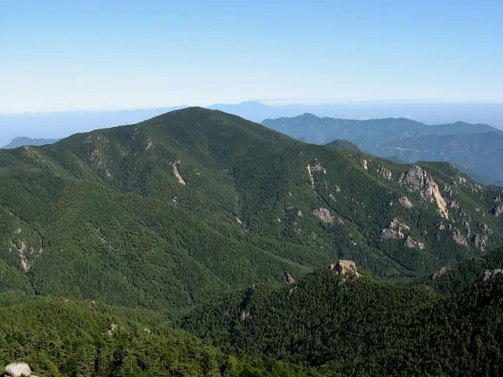
Mount Ogawa rises to 2,418 m on the border between Hokuto City in Yamanashi and Kawakami Village in Nagano, at the north-western edge of the Okuchichibu massif within Chichibu-Tama-Kai National Park and the Kobushi UNESCO Biosphere Reserve. Granite slabs and pinnacles stitched across its flanks have made it a magnet for free climbers since the 1980s, earning it the nickname "Japan's Yosemite." The standard trail starts from Mawarime-daira in Kawakami Village, leaving the Kinpu Sansō hut and campground for a roughly four-hour climb to the summit. The peak appears in Yamanashi Hyakumeizan and Shinshū Hyakumeizan, its forested ridges and pale slabs giving it a distinctive character.
Mount Ogawa at a glance
- Weather: The most settled day in the next 7 days is Sun, November 8: clear, gusts up to 6 m/s.
Mount Ogawa weather (hourly, 14 days)
Sunrise today 06:09, sunset 16:49
| Tue, 11/3 | Wed, 11/4 | Thu, 11/5 | Fri, 11/6 | Sat, 11/7 | Sun, 11/8 | Mon, 11/9 | Tue, 11/10 | Wed, 11/11 | Thu, 11/12 | Fri, 11/13 | Sat, 11/14 | Sun, 11/15 | Mon, 11/16 | Tue, 11/17 | |||||||||||||||||||||||||||||||||||||||||||||||||||||||||||||||||||||||
|---|---|---|---|---|---|---|---|---|---|---|---|---|---|---|---|---|---|---|---|---|---|---|---|---|---|---|---|---|---|---|---|---|---|---|---|---|---|---|---|---|---|---|---|---|---|---|---|---|---|---|---|---|---|---|---|---|---|---|---|---|---|---|---|---|---|---|---|---|---|---|---|---|---|---|---|---|---|---|---|---|---|---|---|---|---|
| Japan time | 21 | 23 | 1 | 3 | 5 | 7 | 9 | 11 | 13 | 15 | 17 | 19 | 21 | 0 | 3 | 6 | 9 | 12 | 15 | 18 | 21 | 0 | 3 | 6 | 9 | 12 | 15 | 18 | 21 | 0 | 3 | 6 | 9 | 12 | 15 | 18 | 21 | 0 | 3 | 6 | 9 | 12 | 15 | 18 | 21 | 0 | 3 | 6 | 9 | 12 | 15 | 21 | 3 | 9 | 15 | 21 | 3 | 9 | 15 | 21 | 3 | 9 | 15 | 21 | 3 | 9 | 15 | 21 | 3 | 9 | 15 | 21 | 3 | 9 | 15 | 21 | 3 | 9 | 15 | 21 | 3 | 9 | 15 | 21 | |
  | | | | |   | |   | | | |   | | | |   |   | |   |   | |  |   | |  | | | | | | | | | | | | | | | | | | | | | | | |   |   | |   | |   |   | | |   | | |  | | | | | | | | | | | | | | | | | | | | | | | | ||
| Temperature | °C | -2° | -2° | -1° | -2° | -2° | -2° | 1° | 4° | 5° | 2° | 1° | 0° | 0° | 0° | 1° | 1° | 4° | 9° | 7° | 3° | 3° | 2° | 2° | 2° | 6° | 8° | 7° | 1° | -1° | -4° | -6° | -5° | 0° | 1° | 0° | -5° | -7° | -7° | -7° | -7° | 1° | 3° | 1° | -4° | -3° | -3° | -2° | -1° | 1° | 5° | 2° | -4° | -6° | -4° | -1° | -4° | -5° | -5° | -5° | -8° | -7° | -1° | 1° | -6° | -6° | -2° | -1° | -7° | -6° | 2° | 3° | -5° | -4° | 2° | 3° | 1° | 1° | 7° | 3° | -5° | -5° | 0° | 1° | -2° |
| Precipitation | mm | 0.4 | 1.5 | 7 | 8 | 3.9 | 0.5 | 0.2 | 0.8 | 0.3 | 0.2 | 0.3 | 0.2 | 0.2 | 1.5 | 4.2 | 1.3 | 1.8 | 0.2 | 0.2 | 6 | 8 | 0.4 | 0.7 | |||||||||||||||||||||||||||||||||||||||||||||||||||||||||||||
| New snow | cm | 0.7 | 3.3 | 0.8 | 0.2 | 0.2 | <.1 | ||||||||||||||||||||||||||||||||||||||||||||||||||||||||||||||||||||||||||||||
| Snow depth | cm | 0 | 0 | 0 | 0 | 0 | 0 | 0 | 0 | 0 | 0 | 0 | 0 | 0 | 0 | 0 | 0 | 0 | 0 | 0 | 0 | 0 | 0 | 0 | 0 | 0 | 0 | 0 | 0 | 0 | 0 | 0 | 0 | 0 | 0 | 0 | 0 | 0 | 0 | 0 | 0 | 0 | 0 | 0 | 0 | 0 | 0 | 0 | 0 | 0 | 0 | 0 | <1 | 3 | 3 | 2 | <1 | <1 | <1 | <1 | <1 | <1 | <1 | <1 | <1 | <1 | <1 | <1 | <1 | <1 | <1 | <1 | <1 | <1 | <1 | <1 | <1 | 0 | 0 | 0 | 0 | 0 | 0 | 0 | 0 |
| Wind | m/s | 0 | 1 | 0 | 1 | 0 | 1 | 1 | 2 | 2 | 1 | 1 | 2 | 2 | 2 | 1 | 1 | 1 | 1 | 1 | 2 | 3 | 3 | 3 | 2 | 3 | 4 | 4 | 2 | 2 | 2 | 2 | 3 | 4 | 4 | 4 | 2 | 1 | 1 | 1 | 1 | 1 | 1 | 1 | 1 | 2 | 3 | 3 | 2 | 2 | 3 | 2 | 1 | 0 | 1 | 3 | 3 | 5 | 8 | 6 | 1 | 1 | 2 | 2 | 1 | 1 | 4 | 2 | 1 | 0 | 1 | 1 | 2 | 2 | 3 | 3 | 3 | 4 | 3 | 4 | 1 | 2 | 2 | 1 | 2 |
| Wind gusts | m/s | 4 | 3 | 3 | 3 | 4 | 4 | 5 | 7 | 8 | 8 | 6 | 6 | 7 | 7 | 7 | 7 | 4 | 6 | 6 | 6 | 7 | 9 | 11 | 10 | 10 | 13 | 13 | 11 | 9 | 8 | 9 | 10 | 13 | 13 | 12 | 11 | 7 | 5 | 5 | 4 | 6 | 6 | 6 | 5 | 6 | 8 | 9 | 8 | 8 | 9 | 9 | 5 | 4 | 5 | 9 | 9 | 14 | 21 | 22 | 16 | 6 | 7 | 9 | 6 | 4 | 11 | 13 | 6 | 5 | 4 | 5 | 5 | 6 | 9 | 12 | 11 | 14 | 12 | 11 | 13 | 6 | 7 | 7 | 6 |
| Wind dir. | ↓ | ↓ | ↓ | ↓ | ↓ | ↓ | ↓ | ↓ | ↓ | ↓ | ↓ | ↓ | ↓ | ↓ | ↓ | ↓ | ↓ | ↓ | ↓ | ↓ | ↓ | ↓ | ↓ | ↓ | ↓ | ↓ | ↓ | ↓ | ↓ | ↓ | ↓ | ↓ | ↓ | ↓ | ↓ | ↓ | ↓ | ↓ | ↓ | ↓ | ↓ | ↓ | ↓ | ↓ | ↓ | ↓ | ↓ | ↓ | ↓ | ↓ | ↓ | ↓ | ↓ | ↓ | ↓ | ↓ | ↓ | ↓ | ↓ | ↓ | ↓ | ↓ | ↓ | ↓ | ↓ | ↓ | ↓ | ↓ | ↓ | ↓ | ↓ | ↓ | ↓ | ↓ | ↓ | ↓ | ↓ | ↓ | ↓ | ↓ | ↓ | ↓ | ↓ | ↓ | |
Huts, campsites and lodging near Mount Ogawa
Mountain huts
- 金峰山荘 reservation required
- 大日小屋 unstaffed
- 富士見平小屋 reservation required · sleeps 24
- 金峰山小屋 2026: open April 25–November 25 · reservation required
- 瑞牆山荘 reservation required
Campsites
- 貸しテント場
- 廻り目平キャンプ場
- 中央広場
- 大日小屋
- Mt. Mizugaki Nature Park
Lodging
- バンガロー
Lists that include Mount Ogawa
Yamanashi 100 Famous Mountains · Shinshu 100 Famous Mountains · 1000 Mountains of Japan
Mount Ogawa facts
- Elevation
- 2,418 m
- Location
- Kawakami, Nagano
35.909448, 138.612292 - National Park
- 秩父多摩甲斐国立公園
- Website
- www.vill.kawakami.nagano.jp
- Trail Map
- www.pref.yamanashi.jp (PDF)
- Wikipedia
- ja.wikipedia.org