
Mount Kobushi
甲武信ヶ岳
Yamanashi, Yamanashi · Elevation 2,475 m
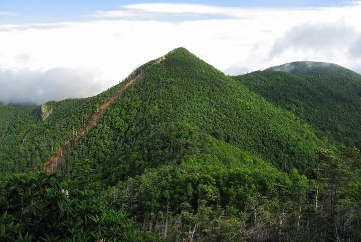
Mount Kobushi is a 2,475 m principal peak of the Oku-Chichibu range in Yamanashi City near the meeting point of Yamanashi, Saitama, and Nagano prefectures; its name combines the initials of the old provinces Koshu, Bushu, and Shinshu, and its form resembles a clenched fist. Within Chichibu-Tama-Kai National Park, its summit divides the watersheds of the Arakawa, Fuefuki (Fuji), and Chikuma (Shinano) rivers. Routes include the shortest approach from Mokidaira in Kawakami along the Chikuma headwaters, an approach from Nishizawa Gorge in Yamanashi, and one via Jumonji Pass from the Saitama side. Kobushi-goya, just below the summit, operates from late April to late November.
Mount Kobushi at a glance
- Weather: The most settled day in the next 7 days is Sun, November 8: clear, gusts up to 6 m/s.
- Route: The shortest is Mount Kobushigatake Round Trip via Tokuchan Trail from Nishizawa Gorge Entrance: about 9 h 21 min, 15.1 km, about 1,630 m of climbing.
Mount Kobushi weather (hourly, 14 days)
Sunrise today 06:09, sunset 16:49
| Tue, 11/3 | Wed, 11/4 | Thu, 11/5 | Fri, 11/6 | Sat, 11/7 | Sun, 11/8 | Mon, 11/9 | Tue, 11/10 | Wed, 11/11 | Thu, 11/12 | Fri, 11/13 | Sat, 11/14 | Sun, 11/15 | Mon, 11/16 | Tue, 11/17 | |||||||||||||||||||||||||||||||||||||||||||||||||||||||||||||||||||||||
|---|---|---|---|---|---|---|---|---|---|---|---|---|---|---|---|---|---|---|---|---|---|---|---|---|---|---|---|---|---|---|---|---|---|---|---|---|---|---|---|---|---|---|---|---|---|---|---|---|---|---|---|---|---|---|---|---|---|---|---|---|---|---|---|---|---|---|---|---|---|---|---|---|---|---|---|---|---|---|---|---|---|---|---|---|---|
| Japan time | 15 | 17 | 19 | 21 | 23 | 1 | 3 | 5 | 7 | 9 | 11 | 13 | 15 | 18 | 21 | 0 | 3 | 6 | 9 | 12 | 15 | 18 | 21 | 0 | 3 | 6 | 9 | 12 | 15 | 18 | 21 | 0 | 3 | 6 | 9 | 12 | 15 | 18 | 21 | 0 | 3 | 6 | 9 | 12 | 15 | 18 | 21 | 0 | 3 | 6 | 9 | 15 | 21 | 3 | 9 | 15 | 21 | 3 | 9 | 15 | 21 | 3 | 9 | 15 | 21 | 3 | 9 | 15 | 21 | 3 | 9 | 15 | 21 | 3 | 9 | 15 | 21 | 3 | 9 | 15 | 21 | 3 | 9 | 15 | |
  |   |   |   | | | | |   | | | | | | | | | |   |   | | |   |  | | |  | | | | | | | | |   | | | | | | | | | |   | | | | | | |   | |   |   | | |   | |   |  | | | | | | | | | | | | | | | | | | | | | | | ||
| Temperature | °C | 2° | 0° | -1° | -1° | -1° | -1° | -1° | -1° | -1° | 0° | 3° | 3° | 2° | 0° | -1° | 0° | 0° | 1° | 3° | 8° | 6° | 3° | 2° | 1° | 1° | 1° | 7° | 10° | 9° | 2° | -1° | -4° | -5° | -5° | 1° | 2° | 2° | -5° | -7° | -7° | -7° | -7° | 1° | 4° | 1° | -4° | -2° | -3° | -3° | -3° | 0° | -1° | -4° | -6° | -4° | -1° | -4° | -6° | -4° | -4° | -8° | -8° | -1° | 1° | -5° | -7° | -1° | 0° | -7° | -7° | 1° | 2° | -6° | -5° | 2° | 4° | 1° | 1° | 7° | 4° | -4° | -4° | -1° | 0° |
| Precipitation | mm | 0.7 | 0.3 | 0.2 | 0.2 | 0.2 | 0.1 | 0.3 | 0.4 | 0.5 | 0.6 | 0.3 | 4.8 | 9 | 7 | 0.3 | 1.8 | 0.3 | 0.1 | 0.4 | 1.6 | 6 | 2.9 | 0.5 | 0.2 | 0.2 | 6 | 9 | 0.3 | 0.4 | |||||||||||||||||||||||||||||||||||||||||||||||||||||||
| New snow | cm | 0.4 | 3.6 | 2.0 | <.1 | 0.2 | <.1 | ||||||||||||||||||||||||||||||||||||||||||||||||||||||||||||||||||||||||||||||
| Snow depth | cm | 0 | 0 | 0 | 0 | 0 | 0 | 0 | 0 | 0 | 0 | 0 | 0 | 0 | 0 | 0 | 0 | 0 | 0 | 0 | 0 | 0 | 0 | 0 | 0 | 0 | 0 | 0 | 0 | 0 | 0 | 0 | 0 | 0 | 0 | 0 | 0 | 0 | 0 | 0 | 0 | 0 | 0 | 0 | 0 | 0 | 0 | 0 | 0 | 0 | 0 | 0 | 0 | <1 | 3 | 4 | 2 | <1 | <1 | <1 | <1 | <1 | <1 | <1 | <1 | <1 | <1 | <1 | <1 | <1 | <1 | <1 | <1 | <1 | <1 | <1 | <1 | <1 | 0 | 0 | 0 | 0 | 0 | 0 | 0 |
| Wind | m/s | 2 | 1 | 1 | 0 | 0 | 0 | 0 | 0 | 1 | 1 | 1 | 2 | 2 | 2 | 2 | 2 | 1 | 0 | 1 | 1 | 1 | 1 | 2 | 1 | 2 | 2 | 2 | 2 | 2 | 2 | 2 | 3 | 3 | 4 | 3 | 3 | 3 | 1 | 1 | 1 | 1 | 1 | 0 | 1 | 2 | 1 | 1 | 1 | 1 | 1 | 0 | 2 | 1 | 0 | 1 | 1 | 1 | 4 | 8 | 6 | 3 | 1 | 0 | 1 | 0 | 2 | 4 | 2 | 2 | 1 | 1 | 1 | 1 | 1 | 2 | 1 | 2 | 2 | 2 | 4 | 3 | 1 | 0 | 1 |
| Wind gusts | m/s | 6 | 5 | 3 | 3 | 3 | 3 | 3 | 3 | 3 | 5 | 6 | 7 | 7 | 6 | 6 | 7 | 7 | 7 | 4 | 5 | 6 | 6 | 5 | 6 | 7 | 7 | 7 | 9 | 9 | 8 | 7 | 9 | 10 | 11 | 12 | 12 | 12 | 10 | 5 | 6 | 5 | 5 | 5 | 6 | 6 | 5 | 5 | 5 | 5 | 5 | 5 | 7 | 4 | 4 | 5 | 7 | 6 | 12 | 24 | 24 | 18 | 8 | 6 | 7 | 6 | 5 | 12 | 14 | 8 | 6 | 4 | 6 | 5 | 5 | 6 | 9 | 8 | 11 | 10 | 13 | 14 | 8 | 5 | 6 |
| Wind dir. | ↓ | ↓ | ↓ | ↓ | ↓ | ↓ | ↓ | ↓ | ↓ | ↓ | ↓ | ↓ | ↓ | ↓ | ↓ | ↓ | ↓ | ↓ | ↓ | ↓ | ↓ | ↓ | ↓ | ↓ | ↓ | ↓ | ↓ | ↓ | ↓ | ↓ | ↓ | ↓ | ↓ | ↓ | ↓ | ↓ | ↓ | ↓ | ↓ | ↓ | ↓ | ↓ | ↓ | ↓ | ↓ | ↓ | ↓ | ↓ | ↓ | ↓ | ↓ | ↓ | ↓ | ↓ | ↓ | ↓ | ↓ | ↓ | ↓ | ↓ | ↓ | ↓ | ↓ | ↓ | ↓ | ↓ | ↓ | ↓ | ↓ | ↓ | ↓ | ↓ | ↓ | ↓ | ↓ | ↓ | ↓ | ↓ | ↓ | ↓ | ↓ | ↓ | ↓ | ↓ | |
Mount Kobushi hiking routes
- Mount Kobushigatake Round Trip via Tokuchan Trail from Nishizawa Gorge Entrance 15.1 km · Ascent 1,633 m parking
- Mount Kobushigatake and Mount Sanpo Loop from Mokidaira via the Chikuma River Source and Jumonji Pass 15.3 km · Ascent 1,376 m 毛木平, 毛木場駐車場
Hiking times are estimates calculated from the terrain.
Huts, campsites and lodging near Mount Kobushi
Mountain huts
Lists that include Mount Kobushi
100 Famous Japanese Mountains · Japan 200 Famous Mountains · Japan's 300 Famous Mountains · New 100 Famous Flower Mountains · Kanto 100 Famous Mountains · Koshinetsu 100 Famous Mountains · Yamanashi 100 Famous Mountains · Shinshu 100 Famous Mountains · 50 Mountains of Saitama Prefecture · Shinshu Mountain Cards · Elevations of 1003 Mountains of Japan · 1000 Mountains of Japan
Mount Kobushi facts
- Also known as
- 甲武信岳 · 奥千丈山 · 拳岳 · Kobushiga-dake
- Elevation
- 2,475 m
- Location
- Yamanashi, Yamanashi
35.909183, 138.728871 - National Park
- 秩父多摩甲斐国立公園
- Website
- www.city.yamanashi.yamanashi.jp
- Trail Map
- www.vill.kawakami.nagano.jp
- Wikipedia
- ja.wikipedia.org