
Mount Kentoku
乾徳山
Yamanashi, Yamanashi · Elevation 2,031 m
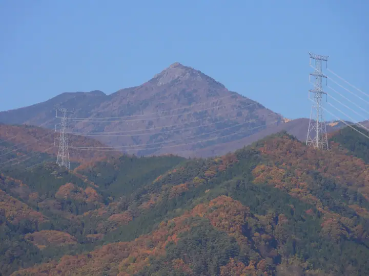
Mount Kentoku is a 2,031 m peak in Mitomi (former Mitomi Village), Yamanashi City, rising as a rocky landmark in the southwestern Oku-Chichibu massif. The Rinzai Zen monk Musō Soseki, founder of Erin-ji temple in Enzan, Kōshū City, is said to have trained on this mountain, which has long been venerated as a place of religious practice. The trail leads through forest and the Kokushi-ga-hara meadow past curiously shaped rocks such as Tsukimi-iwa and Higesori-iwa, and finishes with a thrilling chain climb up the roughly 20 m Otoriiwa face to a summit with sweeping 360° views of Fuji, the Southern Alps, and the Oku-Chichibu main ridge. The standard ascent uses the Kinshosui route from the Kentokuyama trailhead at Kentoku Park, often combined with the Dōman ridge to make a loop.
Mount Kentoku at a glance
- Weather: The most settled day in the next 7 days is Sun, November 8: clear, gusts up to 7 m/s. Sat, Nov 7: strong wind (gusts up to 16 m/s).
- Route: The shortest is Mount Kentoku Round Trip from Otaira: about 4 h 38 min, 7.6 km, about 720 m of climbing.
Mount Kentoku weather (hourly, 14 days)
Sunrise today 06:09, sunset 16:49
| Tue, 11/3 | Wed, 11/4 | Thu, 11/5 | Fri, 11/6 | Sat, 11/7 | Sun, 11/8 | Mon, 11/9 | Tue, 11/10 | Wed, 11/11 | Thu, 11/12 | Fri, 11/13 | Sat, 11/14 | Sun, 11/15 | Mon, 11/16 | Tue, 11/17 | |||||||||||||||||||||||||||||||||||||||||||||||||||||||||||||||||||||||
|---|---|---|---|---|---|---|---|---|---|---|---|---|---|---|---|---|---|---|---|---|---|---|---|---|---|---|---|---|---|---|---|---|---|---|---|---|---|---|---|---|---|---|---|---|---|---|---|---|---|---|---|---|---|---|---|---|---|---|---|---|---|---|---|---|---|---|---|---|---|---|---|---|---|---|---|---|---|---|---|---|---|---|---|---|---|
| Japan time | 15 | 17 | 19 | 21 | 23 | 1 | 3 | 5 | 7 | 9 | 11 | 13 | 15 | 18 | 21 | 0 | 3 | 6 | 9 | 12 | 15 | 18 | 21 | 0 | 3 | 6 | 9 | 12 | 15 | 18 | 21 | 0 | 3 | 6 | 9 | 12 | 15 | 18 | 21 | 0 | 3 | 6 | 9 | 12 | 15 | 18 | 21 | 0 | 3 | 6 | 9 | 15 | 21 | 3 | 9 | 15 | 21 | 3 | 9 | 15 | 21 | 3 | 9 | 15 | 21 | 3 | 9 | 15 | 21 | 3 | 9 | 15 | 21 | 3 | 9 | 15 | 21 | 3 | 9 | 15 | 21 | 3 | 9 | 15 | |
  |   | | | | |   | |   | | | | | | | | |   | |   | | |   |  | | |  | | | | | | | | | | | | | | | |   | | |   | | | | | | |   | |   |   | | |   | |   |  | | | | | | | | | | | | | | | | | | | | | |   | ||
| Temperature | °C | 4° | 2° | 1° | 1° | 1° | 1° | 1° | 1° | 1° | 2° | 5° | 5° | 4° | 2° | 2° | 2° | 2° | 3° | 6° | 11° | 8° | 5° | 4° | 4° | 4° | 3° | 8° | 12° | 11° | 4° | 0° | -1° | -3° | -4° | 2° | 3° | 3° | -3° | -5° | -4° | -3° | -4° | 3° | 6° | 4° | -2° | 0° | -1° | -1° | -1° | 3° | 2° | -2° | -4° | -2° | 2° | -2° | -5° | -2° | -2° | -7° | -5° | 1° | 3° | -3° | -5° | 2° | 3° | -5° | -4° | 3° | 4° | -3° | -3° | 3° | 4° | 3° | 3° | 8° | 8° | -2° | 0° | 1° | 2° |
| Precipitation | mm | 0.5 | 0.2 | 0.2 | 0.6 | 0.9 | 0.6 | 0.2 | 1.0 | 0.1 | 6 | 11 | 8 | 1.1 | 1.4 | 0.5 | 0.1 | 0.9 | 2.6 | 6 | 2.2 | 0.2 | 0.3 | 11 | 13 | 0.2 | 0.1 | ||||||||||||||||||||||||||||||||||||||||||||||||||||||||||
| New snow | cm | 0.6 | 3.8 | 1.3 | <.1 | <.1 | |||||||||||||||||||||||||||||||||||||||||||||||||||||||||||||||||||||||||||||||
| Snow depth | cm | 0 | 0 | 0 | 0 | 0 | 0 | 0 | 0 | 0 | 0 | 0 | 0 | 0 | 0 | 0 | 0 | 0 | 0 | 0 | 0 | 0 | 0 | 0 | 0 | 0 | 0 | 0 | 0 | 0 | 0 | 0 | 0 | 0 | 0 | 0 | 0 | 0 | 0 | 0 | 0 | 0 | 0 | 0 | 0 | 0 | 0 | 0 | 0 | 0 | 0 | 0 | 0 | <1 | 4 | 4 | 2 | 2 | 2 | 2 | 2 | 2 | 2 | 1 | 1 | 1 | 1 | 1 | 1 | 1 | 1 | 1 | <1 | <1 | <1 | <1 | <1 | <1 | 0 | 0 | 0 | 0 | 0 | 0 | 0 |
| Wind | m/s | 0 | 1 | 0 | 0 | 0 | 1 | 0 | 0 | 0 | 1 | 2 | 2 | 1 | 1 | 1 | 1 | 1 | 1 | 1 | 0 | 2 | 1 | 1 | 1 | 1 | 1 | 2 | 3 | 2 | 1 | 1 | 1 | 1 | 2 | 3 | 4 | 2 | 0 | 1 | 1 | 1 | 1 | 1 | 2 | 0 | 0 | 2 | 1 | 1 | 1 | 1 | 1 | 2 | 1 | 0 | 2 | 2 | 2 | 6 | 4 | 1 | 1 | 2 | 2 | 0 | 1 | 2 | 1 | 1 | 1 | 1 | 1 | 2 | 1 | 3 | 2 | 3 | 3 | 2 | 3 | 2 | 2 | 2 | 2 |
| Wind gusts | m/s | 5 | 4 | 4 | 4 | 4 | 4 | 4 | 4 | 4 | 5 | 7 | 7 | 7 | 6 | 7 | 7 | 7 | 8 | 7 | 5 | 8 | 9 | 7 | 7 | 8 | 8 | 9 | 11 | 12 | 9 | 7 | 8 | 10 | 12 | 14 | 16 | 15 | 11 | 7 | 7 | 8 | 7 | 7 | 7 | 7 | 5 | 8 | 8 | 8 | 8 | 7 | 8 | 5 | 5 | 5 | 10 | 8 | 12 | 21 | 22 | 16 | 7 | 8 | 9 | 7 | 6 | 10 | 12 | 5 | 5 | 5 | 7 | 7 | 7 | 9 | 13 | 14 | 14 | 13 | 12 | 13 | 8 | 7 | 8 |
| Wind dir. | ↓ | ↓ | ↓ | ↓ | ↓ | ↓ | ↓ | ↓ | ↓ | ↓ | ↓ | ↓ | ↓ | ↓ | ↓ | ↓ | ↓ | ↓ | ↓ | ↓ | ↓ | ↓ | ↓ | ↓ | ↓ | ↓ | ↓ | ↓ | ↓ | ↓ | ↓ | ↓ | ↓ | ↓ | ↓ | ↓ | ↓ | ↓ | ↓ | ↓ | ↓ | ↓ | ↓ | ↓ | ↓ | ↓ | ↓ | ↓ | ↓ | ↓ | ↓ | ↓ | ↓ | ↓ | ↓ | ↓ | ↓ | ↓ | ↓ | ↓ | ↓ | ↓ | ↓ | ↓ | ↓ | ↓ | ↓ | ↓ | ↓ | ↓ | ↓ | ↓ | ↓ | ↓ | ↓ | ↓ | ↓ | ↓ | ↓ | ↓ | ↓ | ↓ | ↓ | ↓ | |
Mount Kentoku hiking routes
- Mount Kentoku Round Trip from Otaira 7.6 km · Ascent 722 m parking
- Mount Kentoku and Domanyama Figure-Eight Loop from Tokawa 10.6 km · Ascent 1,207 m Kentokusan ent. (Bus stop) (parking)
- Mount Kentoku–Mount Doman Figure-Eight Circuit 11.3 km · Ascent 1,249 m Kentokusan ent. (Bus stop) (parking)
Hiking times are estimates calculated from the terrain.
Huts, campsites and lodging near Mount Kentoku
Mountain huts
Lodging
- 三徳荘
- 和楽荘
- 中村屋
- 山縣館
Lists that include Mount Kentoku
Japan 200 Famous Mountains · Japan's 300 Famous Mountains · New 100 Famous Flower Mountains · Koshinetsu 100 Famous Mountains · Yamanashi 100 Famous Mountains · Elevations of 1003 Mountains of Japan · 1000 Mountains of Japan
Mount Kentoku facts
- Also known as
- Kentokusan
- Elevation
- 2,031 m
- Location
- Yamanashi, Yamanashi
35.822837, 138.714924 - Website
- www.yamanashishi-kankou.com
- Trail Map
- www.pref.yamanashi.jp
- Wikipedia
- ja.wikipedia.org