
Mt. Kokushigatake
国師ヶ岳
Kawakami, Nagano / Yamanashi, Yamanashi · Elevation 2,592 m
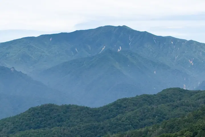
Kokushi-ga-take (2,592 m) rises on the boundary of Yamanashi City (Yamanashi) and Kawakami Village (Nagano), along the main ridge of the Oku-Chichibu range within Chichibu-Tama-Kai National Park. It is included in the 300 Famous Mountains, 100 Famous Flower Mountains, 100 Famous Mountains of Yamanashi, and 100 Mountains of First-Class Triangulation Points. The name is traditionally linked to the Kamakura–Muromachi-era priest Musō Kokushi; today the peak is most easily reached by a one-hour trail of boardwalks and stairs from Ōdarumi Pass (2,360 m) — the highest pass in Japan reachable by ordinary road.
Mt. Kokushigatake at a glance
- Weather: The most settled day in the next 7 days is Sun, November 8: clear, gusts up to 8 m/s. Sat, Nov 7: strong wind (gusts up to 16 m/s).
- Route: The shortest is Kokushigatake and Kita-okusenjo-dake from Oodarumi Pass: about 1 h 51 min, 2.8 km, about 280 m of climbing.
Mt. Kokushigatake weather (hourly, 14 days)
Sunrise today 06:09, sunset 16:49
| Tue, 11/3 | Wed, 11/4 | Thu, 11/5 | Fri, 11/6 | Sat, 11/7 | Sun, 11/8 | Mon, 11/9 | Tue, 11/10 | Wed, 11/11 | Thu, 11/12 | Fri, 11/13 | Sat, 11/14 | Sun, 11/15 | Mon, 11/16 | Tue, 11/17 | |||||||||||||||||||||||||||||||||||||||||||||||||||||||||||||||||||||||
|---|---|---|---|---|---|---|---|---|---|---|---|---|---|---|---|---|---|---|---|---|---|---|---|---|---|---|---|---|---|---|---|---|---|---|---|---|---|---|---|---|---|---|---|---|---|---|---|---|---|---|---|---|---|---|---|---|---|---|---|---|---|---|---|---|---|---|---|---|---|---|---|---|---|---|---|---|---|---|---|---|---|---|---|---|---|
| Japan time | 15 | 17 | 19 | 21 | 23 | 1 | 3 | 5 | 7 | 9 | 11 | 13 | 15 | 18 | 21 | 0 | 3 | 6 | 9 | 12 | 15 | 18 | 21 | 0 | 3 | 6 | 9 | 12 | 15 | 18 | 21 | 0 | 3 | 6 | 9 | 12 | 15 | 18 | 21 | 0 | 3 | 6 | 9 | 12 | 15 | 18 | 21 | 0 | 3 | 6 | 9 | 15 | 21 | 3 | 9 | 15 | 21 | 3 | 9 | 15 | 21 | 3 | 9 | 15 | 21 | 3 | 9 | 15 | 21 | 3 | 9 | 15 | 21 | 3 | 9 | 15 | 21 | 3 | 9 | 15 | 21 | 3 | 9 | 15 | |
  |   |   | | |   | | |   | | | |   | | | | |   |   | | |   | |  |   | |  | | | | | | | | | | | | | | | |   | | | | | | | | | |   | |   |   | | |   | |   |  | | | | | | | | | | | | | | | | | | | | | | | ||
| Temperature | °C | 5° | 1° | 1° | 1° | 0° | 0° | 0° | 0° | 0° | 2° | 5° | 5° | 4° | 2° | 2° | 2° | 2° | 2° | 6° | 10° | 7° | 5° | 4° | 4° | 4° | 3° | 7° | 10° | 10° | 3° | 1° | -1° | -3° | -3° | 1° | 2° | 2° | -4° | -5° | -4° | -4° | -5° | 2° | 5° | 3° | -2° | -1° | -1° | -1° | -1° | 2° | 2° | -2° | -4° | -2° | 1° | -3° | -5° | -3° | -3° | -8° | -5° | -1° | 1° | -3° | -6° | 0° | 2° | -6° | -5° | 2° | 3° | -3° | -2° | 2° | 3° | 2° | 2° | 7° | 7° | -3° | -2° | 0° | 1° |
| Precipitation | mm | 0.2 | 0.1 | 0.2 | 0.1 | 0.3 | 4.7 | 10 | 6 | 0.7 | 0.1 | 1.6 | 0.3 | 0.1 | 0.5 | 2.9 | 5 | 2.5 | 0.4 | 0.4 | 10 | 11 | 0.1 | ||||||||||||||||||||||||||||||||||||||||||||||||||||||||||||||
| New snow | cm | 0.3 | 1.6 | 0.7 | <.1 | <.1 | |||||||||||||||||||||||||||||||||||||||||||||||||||||||||||||||||||||||||||||||
| Snow depth | cm | 0 | 0 | 0 | 0 | 0 | 0 | 0 | 0 | 0 | 0 | 0 | 0 | 0 | 0 | 0 | 0 | 0 | 0 | 0 | 0 | 0 | 0 | 0 | 0 | 0 | 0 | 0 | 0 | 0 | 0 | 0 | 0 | 0 | 0 | 0 | 0 | 0 | 0 | 0 | 0 | 0 | 0 | 0 | 0 | 0 | 0 | 0 | 0 | 0 | 0 | 0 | 0 | <1 | 2 | 2 | 1 | <1 | <1 | <1 | <1 | <1 | <1 | <1 | <1 | <1 | <1 | <1 | <1 | <1 | <1 | <1 | <1 | <1 | <1 | <1 | <1 | <1 | 0 | 0 | 0 | 0 | 0 | 0 | 0 |
| Wind | m/s | 1 | 0 | 0 | 0 | 0 | 1 | 0 | 0 | 0 | 1 | 2 | 2 | 2 | 1 | 1 | 1 | 1 | 0 | 0 | 1 | 2 | 0 | 0 | 0 | 1 | 1 | 3 | 4 | 3 | 2 | 1 | 1 | 2 | 3 | 4 | 4 | 3 | 1 | 0 | 0 | 0 | 0 | 2 | 2 | 1 | 0 | 1 | 1 | 1 | 0 | 2 | 0 | 1 | 1 | 1 | 2 | 1 | 3 | 6 | 4 | 2 | 0 | 2 | 2 | 0 | 1 | 3 | 2 | 1 | 0 | 1 | 1 | 0 | 0 | 2 | 2 | 4 | 1 | 2 | 4 | 2 | 1 | 3 | 2 |
| Wind gusts | m/s | 7 | 4 | 4 | 4 | 3 | 3 | 3 | 3 | 3 | 6 | 8 | 8 | 8 | 6 | 7 | 7 | 7 | 6 | 5 | 6 | 8 | 8 | 5 | 6 | 8 | 9 | 12 | 14 | 14 | 11 | 9 | 9 | 11 | 13 | 16 | 16 | 15 | 12 | 7 | 6 | 6 | 6 | 7 | 8 | 8 | 5 | 6 | 7 | 7 | 6 | 6 | 9 | 6 | 5 | 6 | 9 | 8 | 14 | 21 | 22 | 16 | 8 | 7 | 8 | 7 | 6 | 10 | 13 | 8 | 5 | 5 | 7 | 6 | 5 | 7 | 10 | 13 | 13 | 10 | 15 | 14 | 8 | 8 | 8 |
| Wind dir. | ↓ | ↓ | ↓ | ↓ | ↓ | ↓ | ↓ | ↓ | ↓ | ↓ | ↓ | ↓ | ↓ | ↓ | ↓ | ↓ | ↓ | ↓ | ↓ | ↓ | ↓ | ↓ | ↓ | ↓ | ↓ | ↓ | ↓ | ↓ | ↓ | ↓ | ↓ | ↓ | ↓ | ↓ | ↓ | ↓ | ↓ | ↓ | ↓ | ↓ | ↓ | ↓ | ↓ | ↓ | ↓ | ↓ | ↓ | ↓ | ↓ | ↓ | ↓ | ↓ | ↓ | ↓ | ↓ | ↓ | ↓ | ↓ | ↓ | ↓ | ↓ | ↓ | ↓ | ↓ | ↓ | ↓ | ↓ | ↓ | ↓ | ↓ | ↓ | ↓ | ↓ | ↓ | ↓ | ↓ | ↓ | ↓ | ↓ | ↓ | ↓ | ↓ | ↓ | ||
Mt. Kokushigatake hiking routes
- Kokushigatake and Kita-okusenjo-dake from Oodarumi Pass 2.8 km · Ascent 281 m parking
- Mount Kinpu, Kokushigatake and Kita-Okusenjodake Loop from Oodarumi Pass 11.0 km · Ascent 830 m parking
Hiking times are estimates calculated from the terrain.
Huts, campsites and lodging near Mt. Kokushigatake
Mountain huts
- 大弛小屋 2026: open April 30–November 30 · reservation required · sleeps 30
- 金峰山小屋 2026: open April 25–November 25 · reservation required
Campsites
- 大弛小屋テントサイト
Lists that include Mt. Kokushigatake
Japan's 300 Famous Mountains · 100 Famous Mountains of Flowers · 100 Famous Mountains with First-order Triangulation Points · Yamanashi 100 Famous Mountains · Shinshu 100 Famous Mountains · Elevations of 1003 Mountains of Japan · 1000 Mountains of Japan
Mt. Kokushigatake facts
- Also known as
- 東股山
- Elevation
- 2,592 m
- Location
- Kawakami, Nagano / Yamanashi, Yamanashi
35.870838, 138.672963 - National Park
- 秩父多摩甲斐国立公園
- Website
- www.city.yamanashi.yamanashi.jp
- Trail Map
- www.city.yamanashi.yamanashi.jp (PDF)
- Access Information
- www.city.yamanashi.yamanashi.jp (PDF)
- Wikipedia
- ja.wikipedia.org