
Mt. Kasatori
笠取山
Chichibu, Saitama · Elevation 1,953 m
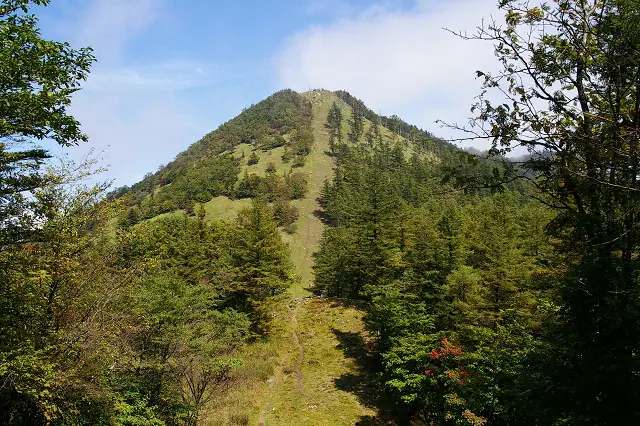
Mt. Kasatori (1,953 m) sits on the border of Chichibu City in Saitama and Kōshū City in Yamanashi, on the Oku-Chichibu range within Chichibu-Tama-Kai National Park. Just below the summit on its southern flank lies the "Mizuhi," the headwater spring from which the Tama River begins, and a watershed marker at the col north of the peak divides the basins of the Tama, Ara, and Fuji rivers. Cloaked in protected old-growth water-source forest, the mountain is loved for early-summer rhododendrons and the gold of larch in autumn. The classic ascent climbs gently along the stream from the Sakubadaira trailhead on the Yamanashi side, and the peak is counted among the 100 Famous Mountains of Yamanashi and Kantō.
Mt. Kasatori at a glance
- Weather: The most settled day in the next 7 days is Sun, November 8: clear, gusts up to 6 m/s.
Mt. Kasatori weather (hourly, 14 days)
Sunrise today 06:08, sunset 16:49
| Tue, 11/3 | Wed, 11/4 | Thu, 11/5 | Fri, 11/6 | Sat, 11/7 | Sun, 11/8 | Mon, 11/9 | Tue, 11/10 | Wed, 11/11 | Thu, 11/12 | Fri, 11/13 | Sat, 11/14 | Sun, 11/15 | Mon, 11/16 | Tue, 11/17 | |||||||||||||||||||||||||||||||||||||||||||||||||||||||||||||||||||||||
|---|---|---|---|---|---|---|---|---|---|---|---|---|---|---|---|---|---|---|---|---|---|---|---|---|---|---|---|---|---|---|---|---|---|---|---|---|---|---|---|---|---|---|---|---|---|---|---|---|---|---|---|---|---|---|---|---|---|---|---|---|---|---|---|---|---|---|---|---|---|---|---|---|---|---|---|---|---|---|---|---|---|---|---|---|---|
| Japan time | 15 | 17 | 19 | 21 | 23 | 1 | 3 | 5 | 7 | 9 | 11 | 13 | 15 | 18 | 21 | 0 | 3 | 6 | 9 | 12 | 15 | 18 | 21 | 0 | 3 | 6 | 9 | 12 | 15 | 18 | 21 | 0 | 3 | 6 | 9 | 12 | 15 | 18 | 21 | 0 | 3 | 6 | 9 | 12 | 15 | 18 | 21 | 0 | 3 | 6 | 9 | 15 | 21 | 3 | 9 | 15 | 21 | 3 | 9 | 15 | 21 | 3 | 9 | 15 | 21 | 3 | 9 | 15 | 21 | 3 | 9 | 15 | 21 | 3 | 9 | 15 | 21 | 3 | 9 | 15 | 21 | 3 | 9 | 15 | |
  |   | | | | |   | |   | | | | | | | | | | |   | | |   |  | | |  | | |   | | | | | | | |   | | | | | | |   | | | | | | | | |   |   |   | | | | |   |  | | | | | | | | | | | | | | | |   | |   | | | | | ||
| Temperature | °C | 5° | 4° | 3° | 3° | 3° | 3° | 3° | 2° | 2° | 3° | 6° | 6° | 5° | 3° | 3° | 3° | 3° | 4° | 7° | 12° | 9° | 6° | 5° | 4° | 4° | 4° | 10° | 14° | 13° | 6° | 3° | 1° | -1° | -2° | 5° | 7° | 6° | 0° | -2° | -2° | -2° | -2° | 5° | 8° | 5° | 0° | 1° | 1° | 0° | 1° | 4° | 3° | 0° | -2° | -1° | 3° | 0° | -4° | 0° | 1° | -5° | -4° | 3° | 4° | -1° | -4° | 4° | 5° | -3° | -3° | 4° | 5° | -2° | -3° | 5° | 6° | 4° | 4° | 10° | 10° | 0° | 2° | 2° | 3° |
| Precipitation | mm | 1.4 | 0.4 | 0.4 | 1.5 | 1.7 | 1.4 | 0.2 | 1.4 | 0.3 | 6 | 12 | 11 | 1.1 | 1.4 | 0.5 | 0.1 | 1.2 | 2.2 | 4.7 | 1.2 | 0.1 | 0.1 | 9 | 14 | 0.1 | 0.3 | ||||||||||||||||||||||||||||||||||||||||||||||||||||||||||
| New snow | cm | 1.7 | 0.6 | ||||||||||||||||||||||||||||||||||||||||||||||||||||||||||||||||||||||||||||||||||
| Snow depth | cm | 0 | 0 | 0 | 0 | 0 | 0 | 0 | 0 | 0 | 0 | 0 | 0 | 0 | 0 | 0 | 0 | 0 | 0 | 0 | 0 | 0 | 0 | 0 | 0 | 0 | 0 | 0 | 0 | 0 | 0 | 0 | 0 | 0 | 0 | 0 | 0 | 0 | 0 | 0 | 0 | 0 | 0 | 0 | 0 | 0 | 0 | 0 | 0 | 0 | 0 | 0 | 0 | 0 | 1 | 1 | <1 | 0 | 0 | 0 | 0 | 0 | 0 | 0 | 0 | 0 | 0 | 0 | 0 | 0 | 0 | 0 | 0 | 0 | 0 | 0 | 0 | 0 | 0 | 0 | 0 | 0 | 0 | 0 | 0 |
| Wind | m/s | 1 | 1 | 0 | 1 | 0 | 0 | 1 | 1 | 1 | 0 | 1 | 2 | 1 | 1 | 1 | 1 | 1 | 1 | 2 | 1 | 2 | 1 | 1 | 1 | 1 | 1 | 1 | 1 | 0 | 1 | 1 | 0 | 1 | 1 | 1 | 3 | 1 | 0 | 1 | 1 | 0 | 1 | 0 | 1 | 1 | 0 | 1 | 1 | 1 | 1 | 1 | 1 | 1 | 0 | 0 | 2 | 1 | 1 | 6 | 4 | 1 | 1 | 1 | 1 | 1 | 1 | 3 | 1 | 1 | 1 | 1 | 1 | 1 | 1 | 2 | 2 | 2 | 3 | 1 | 3 | 2 | 1 | 1 | 1 |
| Wind gusts | m/s | 5 | 4 | 3 | 3 | 3 | 3 | 3 | 4 | 4 | 4 | 5 | 6 | 6 | 6 | 6 | 6 | 6 | 8 | 6 | 6 | 7 | 8 | 6 | 6 | 6 | 6 | 6 | 7 | 7 | 5 | 5 | 5 | 7 | 7 | 8 | 12 | 11 | 7 | 5 | 6 | 6 | 5 | 5 | 6 | 6 | 5 | 6 | 7 | 6 | 6 | 6 | 6 | 5 | 4 | 5 | 9 | 8 | 8 | 21 | 23 | 15 | 6 | 6 | 8 | 6 | 5 | 10 | 12 | 6 | 4 | 4 | 6 | 6 | 6 | 9 | 13 | 10 | 12 | 12 | 10 | 14 | 7 | 5 | 6 |
| Wind dir. | ↓ | ↓ | ↓ | ↓ | ↓ | ↓ | ↓ | ↓ | ↓ | ↓ | ↓ | ↓ | ↓ | ↓ | ↓ | ↓ | ↓ | ↓ | ↓ | ↓ | ↓ | ↓ | ↓ | ↓ | ↓ | ↓ | ↓ | ↓ | ↓ | ↓ | ↓ | ↓ | ↓ | ↓ | ↓ | ↓ | ↓ | ↓ | ↓ | ↓ | ↓ | ↓ | ↓ | ↓ | ↓ | ↓ | ↓ | ↓ | ↓ | ↓ | ↓ | ↓ | ↓ | ↓ | ↓ | ↓ | ↓ | ↓ | ↓ | ↓ | ↓ | ↓ | ↓ | ↓ | ↓ | ↓ | ↓ | ↓ | ↓ | ↓ | ↓ | ↓ | ↓ | ↓ | ↓ | ↓ | ↓ | ↓ | ↓ | ↓ | ↓ | ↓ | ↓ | ↓ | |
Huts, campsites and lodging near Mt. Kasatori
Mountain huts
- 雁峠避難小屋
- 笠取小屋 2026: open April 29–January 3 · reservation required
- 雁坂小屋 2026: open April 29–November 23 · reservation required · sleeps 24
- 将監小屋 sleeps 70
Campsites
- 笠取小屋 テント場
- 一の瀬高原キャンプ場
Lodging
- 民宿みはらし
Lists that include Mt. Kasatori
New 100 Famous Flower Mountains · Kanto 100 Famous Mountains · Yamanashi 100 Famous Mountains · 50 Mountains of Saitama Prefecture
Mt. Kasatori facts
- Elevation
- 1,953 m
- Location
- Chichibu, Saitama
35.865391, 138.819943 - National Park
- 秩父多摩甲斐国立公園
- Website
- www.koshu-kankou.jp
- Access Information
- yamanashi-hiking100.jp
- Wikipedia
- ja.wikipedia.org