
Mount Karisaka-rei
雁坂嶺
Chichibu, Saitama · Elevation 2,289 m
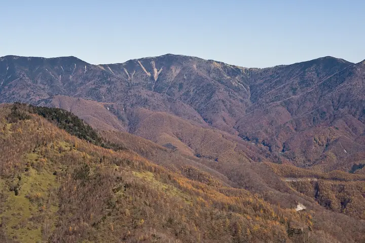
Mount Karisaka-rei is a 2,289.2 m peak on the border between Chichibu City in Saitama and Yamanashi City in Yamanashi, set on the main ridge of the Okuchichibu massif north-west of Karisaka Pass — counted as one of Japan's three great mountain passes at 2,082 m — within Chichibu-Tama-Kai National Park. The summit's south face opens onto bamboo grass and sparse forest, with views of Mount Fuji, Mount Kentoku, and the principal Okuchichibu peaks. The standard approach climbs the historic Chichibu Ōkan road from Michi-no-eki Mitomi or the Karisaka Tunnel toll booth, tops Karisaka Pass, and reaches the summit; many parties continue on traverses to Mount Kobushi or Mount Hafu. The peak features in Yamanashi Hyakumeizan, Kantō Hyakuzan, and Kōshū Hyakuzan.
Mount Karisaka-rei at a glance
- Weather: The most settled day in the next 7 days is Sun, November 8: clear, gusts up to 7 m/s. Sat, Nov 7: strong wind (gusts up to 16 m/s).
Mount Karisaka-rei weather (hourly, 14 days)
Sunrise today 06:08, sunset 16:49
| Tue, 11/3 | Wed, 11/4 | Thu, 11/5 | Fri, 11/6 | Sat, 11/7 | Sun, 11/8 | Mon, 11/9 | Tue, 11/10 | Wed, 11/11 | Thu, 11/12 | Fri, 11/13 | Sat, 11/14 | Sun, 11/15 | Mon, 11/16 | Tue, 11/17 | |||||||||||||||||||||||||||||||||||||||||||||||||||||||||||||||||||||||
|---|---|---|---|---|---|---|---|---|---|---|---|---|---|---|---|---|---|---|---|---|---|---|---|---|---|---|---|---|---|---|---|---|---|---|---|---|---|---|---|---|---|---|---|---|---|---|---|---|---|---|---|---|---|---|---|---|---|---|---|---|---|---|---|---|---|---|---|---|---|---|---|---|---|---|---|---|---|---|---|---|---|---|---|---|---|
| Japan time | 15 | 17 | 19 | 21 | 23 | 1 | 3 | 5 | 7 | 9 | 11 | 13 | 15 | 18 | 21 | 0 | 3 | 6 | 9 | 12 | 15 | 18 | 21 | 0 | 3 | 6 | 9 | 12 | 15 | 18 | 21 | 0 | 3 | 6 | 9 | 12 | 15 | 18 | 21 | 0 | 3 | 6 | 9 | 12 | 15 | 18 | 21 | 0 | 3 | 6 | 9 | 15 | 21 | 3 | 9 | 15 | 21 | 3 | 9 | 15 | 21 | 3 | 9 | 15 | 21 | 3 | 9 | 15 | 21 | 3 | 9 | 15 | 21 | 3 | 9 | 15 | 21 | 3 | 9 | 15 | 21 | 3 | 9 | 15 | |
  |   | | | | |   | |   | | | | | | | | |   | |   | | |   |  | | |  | | | | | | | | | | | | | | | |   | | |   | | | | | | |   | |   |   | | |   | |   |  | | | | | | | | | | | | | | | | | | | | | |   | ||
| Temperature | °C | 2° | 0° | 0° | 0° | -1° | -1° | -1° | -1° | -1° | 1° | 4° | 4° | 3° | 1° | 0° | 1° | 0° | 1° | 4° | 9° | 6° | 4° | 2° | 2° | 2° | 2° | 7° | 10° | 9° | 2° | -1° | -3° | -5° | -5° | 0° | 2° | 1° | -5° | -6° | -5° | -5° | -5° | 1° | 4° | 2° | -4° | -2° | -2° | -3° | -2° | 1° | 0° | -4° | -6° | -4° | 0° | -4° | -7° | -4° | -4° | -9° | -7° | -1° | 1° | -4° | -7° | 0° | 1° | -6° | -6° | 1° | 2° | -5° | -4° | 1° | 2° | 2° | 1° | 7° | 7° | -4° | -2° | -1° | 0° |
| Precipitation | mm | 0.5 | 0.2 | 0.2 | 0.6 | 0.9 | 0.6 | 0.2 | 1.0 | 0.1 | 6 | 11 | 8 | 1.1 | 1.4 | 0.5 | 0.1 | 0.9 | 2.6 | 6 | 2.2 | 0.2 | 0.3 | 11 | 13 | 0.2 | 0.1 | ||||||||||||||||||||||||||||||||||||||||||||||||||||||||||
| New snow | cm | 0.6 | 3.8 | 1.3 | <.1 | <.1 | |||||||||||||||||||||||||||||||||||||||||||||||||||||||||||||||||||||||||||||||
| Snow depth | cm | 0 | 0 | 0 | 0 | 0 | 0 | 0 | 0 | 0 | 0 | 0 | 0 | 0 | 0 | 0 | 0 | 0 | 0 | 0 | 0 | 0 | 0 | 0 | 0 | 0 | 0 | 0 | 0 | 0 | 0 | 0 | 0 | 0 | 0 | 0 | 0 | 0 | 0 | 0 | 0 | 0 | 0 | 0 | 0 | 0 | 0 | 0 | 0 | 0 | 0 | 0 | 0 | <1 | 4 | 4 | 2 | 2 | 2 | 2 | 2 | 2 | 2 | 1 | 1 | 1 | 1 | 1 | 1 | 1 | 1 | 1 | <1 | <1 | <1 | <1 | <1 | <1 | 0 | 0 | 0 | 0 | 0 | 0 | 0 |
| Wind | m/s | 0 | 1 | 0 | 0 | 0 | 1 | 0 | 0 | 0 | 1 | 2 | 2 | 1 | 1 | 1 | 1 | 1 | 1 | 1 | 0 | 2 | 1 | 1 | 1 | 1 | 1 | 2 | 3 | 2 | 1 | 1 | 1 | 1 | 2 | 3 | 4 | 2 | 0 | 1 | 1 | 1 | 1 | 1 | 2 | 0 | 0 | 2 | 1 | 1 | 1 | 1 | 1 | 2 | 1 | 0 | 2 | 2 | 2 | 6 | 4 | 1 | 1 | 2 | 2 | 0 | 1 | 2 | 1 | 1 | 1 | 1 | 1 | 2 | 1 | 3 | 2 | 3 | 3 | 2 | 3 | 2 | 2 | 2 | 2 |
| Wind gusts | m/s | 5 | 4 | 4 | 4 | 4 | 4 | 4 | 4 | 4 | 5 | 7 | 7 | 7 | 6 | 7 | 7 | 7 | 8 | 7 | 5 | 8 | 9 | 7 | 7 | 8 | 8 | 9 | 11 | 12 | 9 | 7 | 8 | 10 | 12 | 14 | 16 | 15 | 11 | 7 | 7 | 8 | 7 | 7 | 7 | 7 | 5 | 8 | 8 | 8 | 8 | 7 | 8 | 5 | 5 | 5 | 10 | 8 | 12 | 21 | 22 | 16 | 7 | 8 | 9 | 7 | 6 | 10 | 12 | 5 | 5 | 5 | 7 | 7 | 7 | 9 | 13 | 14 | 14 | 13 | 12 | 13 | 8 | 7 | 8 |
| Wind dir. | ↓ | ↓ | ↓ | ↓ | ↓ | ↓ | ↓ | ↓ | ↓ | ↓ | ↓ | ↓ | ↓ | ↓ | ↓ | ↓ | ↓ | ↓ | ↓ | ↓ | ↓ | ↓ | ↓ | ↓ | ↓ | ↓ | ↓ | ↓ | ↓ | ↓ | ↓ | ↓ | ↓ | ↓ | ↓ | ↓ | ↓ | ↓ | ↓ | ↓ | ↓ | ↓ | ↓ | ↓ | ↓ | ↓ | ↓ | ↓ | ↓ | ↓ | ↓ | ↓ | ↓ | ↓ | ↓ | ↓ | ↓ | ↓ | ↓ | ↓ | ↓ | ↓ | ↓ | ↓ | ↓ | ↓ | ↓ | ↓ | ↓ | ↓ | ↓ | ↓ | ↓ | ↓ | ↓ | ↓ | ↓ | ↓ | ↓ | ↓ | ↓ | ↓ | ↓ | ↓ | |
Huts, campsites and lodging near Mount Karisaka-rei
Mountain huts
- 雁坂小屋 2026: open April 29–November 23 · reservation required · sleeps 24
- 樺小屋 避難小屋 unstaffed
- 破風山避難小屋 unstaffed
- 柳避難小屋 unstaffed
- Yanagi Hut
Campsites
- 7inchCAMP ミチノエキ・ミトミ DOGBASE
- 笛吹小屋キャンプ場
Lists that include Mount Karisaka-rei
Yamanashi 100 Famous Mountains · 50 Mountains of Saitama Prefecture
Mount Karisaka-rei facts
- Elevation
- 2,289 m
- Location
- Chichibu, Saitama
35.898793, 138.781410 - National Park
- 秩父多摩甲斐国立公園
- Website
- www.city.yamanashi.yamanashi.jp
- Trail Map
- www.pref.yamanashi.jp (PDF)
- Wikipedia
- ja.wikipedia.org