
Kengamine
剣ヶ峰
Daisen, Tottori · Elevation 1,729 m
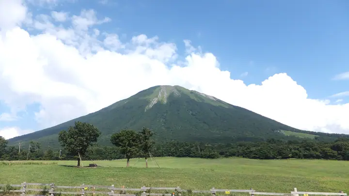
Kengamine (1,729 m) is the true summit of Mount Daisen (Hōki-Daisen) and the highest point in both Tottori Prefecture and the Chūgoku region. Located at the heart of Daisen-Oki National Park, the knife-edge traverse from Misen across to Kengamine has suffered severe erosion, and Tottori Prefecture officially asks hikers to refrain from using it. As a result general hikers stop at the adjacent peak of Misen (1,709 m), and access to Kengamine itself is effectively restricted.
Kengamine at a glance
- Weather: The most settled day in the next 7 days is Wed, November 4: clear, gusts up to 7 m/s. Fri, Nov 6, Sat, Nov 7: strong wind (gusts up to 16 m/s).
Kengamine weather (hourly, 14 days)
Sunrise today 06:28, sunset 17:10
| Tue, 11/3 | Wed, 11/4 | Thu, 11/5 | Fri, 11/6 | Sat, 11/7 | Sun, 11/8 | Mon, 11/9 | Tue, 11/10 | Wed, 11/11 | Thu, 11/12 | Fri, 11/13 | Sat, 11/14 | Sun, 11/15 | Mon, 11/16 | Tue, 11/17 | |||||||||||||||||||||||||||||||||||||||||||||||||||||||||||||||||||||||
|---|---|---|---|---|---|---|---|---|---|---|---|---|---|---|---|---|---|---|---|---|---|---|---|---|---|---|---|---|---|---|---|---|---|---|---|---|---|---|---|---|---|---|---|---|---|---|---|---|---|---|---|---|---|---|---|---|---|---|---|---|---|---|---|---|---|---|---|---|---|---|---|---|---|---|---|---|---|---|---|---|---|---|---|---|---|
| Japan time | 15 | 17 | 19 | 21 | 23 | 1 | 3 | 5 | 7 | 9 | 11 | 13 | 15 | 18 | 21 | 0 | 3 | 6 | 9 | 12 | 15 | 18 | 21 | 0 | 3 | 6 | 9 | 12 | 15 | 18 | 21 | 0 | 3 | 6 | 9 | 12 | 15 | 18 | 21 | 0 | 3 | 6 | 9 | 12 | 15 | 18 | 21 | 0 | 3 | 6 | 9 | 15 | 21 | 3 | 9 | 15 | 21 | 3 | 9 | 15 | 21 | 3 | 9 | 15 | 21 | 3 | 9 | 15 | 21 | 3 | 9 | 15 | 21 | 3 | 9 | 15 | 21 | 3 | 9 | 15 | 21 | 3 | 9 | 15 | |
  | |   | | |   |   | |   |   | | | | | | |   |   | |   | | | | | | | | | | | | | | |   | | | | |  | | | | | | | | | | | | |   | | | | | | | | | |  | | | | | | |  | | | | | | | | | | | | | | | ||
| Temperature | °C | 6° | 4° | 3° | 3° | 3° | 3° | 2° | 1° | 1° | 6° | 8° | 9° | 8° | 4° | 4° | 5° | 4° | 6° | 9° | 9° | 8° | 8° | 7° | 6° | 6° | 5° | 7° | 8° | 7° | 3° | 2° | 2° | 1° | 1° | 2° | 3° | 3° | 1° | 0° | -2° | -2° | -2° | 3° | 5° | 4° | 2° | 2° | 1° | 1° | 1° | 3° | 4° | 0° | -1° | 3° | 4° | 0° | -1° | 1° | 1° | 0° | -1° | 2° | 6° | 1° | 1° | 2° | 3° | 0° | -3° | 4° | 8° | 2° | 3° | 6° | 6° | 6° | 7° | 6° | 3° | 1° | -1° | 1° | 2° |
| Precipitation | mm | 0.8 | 0.5 | 0.4 | 0.2 | 0.1 | 0.4 | 1.0 | 3.5 | 3.7 | 3.5 | 12 | 0.8 | 0.4 | 0.4 | 0.8 | 0.9 | 0.6 | 0.2 | 2.2 | 0.3 | 1.1 | 2.1 | 0.9 | 1.6 | 0.5 | 1.8 | 0.8 | 1.5 | 3.1 | 0.5 | 6 | 17 | 1.6 | 7 | 9 | 6 | 0.3 | 0.1 | ||||||||||||||||||||||||||||||||||||||||||||||
| New snow | cm | ||||||||||||||||||||||||||||||||||||||||||||||||||||||||||||||||||||||||||||||||||||
| Snow depth | cm | 0 | 0 | 0 | 0 | 0 | 0 | 0 | 0 | 0 | 0 | 0 | 0 | 0 | 0 | 0 | 0 | 0 | 0 | 0 | 0 | 0 | 0 | 0 | 0 | 0 | 0 | 0 | 0 | 0 | 0 | 0 | 0 | 0 | 0 | 0 | 0 | 0 | 0 | 0 | 0 | 0 | 0 | 0 | 0 | 0 | 0 | 0 | 0 | 0 | 0 | 0 | 0 | 0 | 0 | 0 | 0 | 0 | 0 | 0 | 0 | 0 | 0 | 0 | 0 | 0 | 0 | 0 | 0 | 0 | 0 | 0 | 0 | 0 | 0 | 0 | 0 | 0 | 0 | 0 | 0 | 0 | 0 | 0 | 0 |
| Wind | m/s | 2 | 0 | 0 | 0 | 1 | 0 | 1 | 1 | 2 | 2 | 2 | 2 | 2 | 1 | 2 | 1 | 1 | 0 | 1 | 1 | 1 | 1 | 1 | 1 | 2 | 3 | 3 | 6 | 5 | 4 | 5 | 4 | 5 | 5 | 6 | 5 | 5 | 2 | 1 | 1 | 0 | 0 | 1 | 3 | 2 | 1 | 0 | 1 | 1 | 1 | 2 | 2 | 2 | 1 | 4 | 5 | 5 | 5 | 4 | 3 | 1 | 1 | 1 | 4 | 2 | 2 | 3 | 3 | 1 | 1 | 1 | 1 | 3 | 3 | 4 | 6 | 1 | 2 | 3 | 4 | 3 | 2 | 2 | 1 |
| Wind gusts | m/s | 7 | 7 | 3 | 3 | 3 | 3 | 4 | 5 | 5 | 6 | 7 | 7 | 7 | 7 | 6 | 8 | 5 | 5 | 4 | 5 | 5 | 7 | 7 | 8 | 8 | 11 | 12 | 16 | 16 | 15 | 15 | 15 | 15 | 15 | 16 | 16 | 15 | 14 | 7 | 5 | 4 | 4 | 5 | 9 | 10 | 6 | 3 | 4 | 4 | 5 | 8 | 10 | 9 | 6 | 11 | 15 | 15 | 18 | 15 | 12 | 9 | 4 | 5 | 12 | 11 | 8 | 10 | 11 | 10 | 5 | 5 | 6 | 8 | 10 | 12 | 20 | 20 | 12 | 10 | 13 | 13 | 9 | 7 | 7 |
| Wind dir. | ↓ | ↓ | ↓ | ↓ | ↓ | ↓ | ↓ | ↓ | ↓ | ↓ | ↓ | ↓ | ↓ | ↓ | ↓ | ↓ | ↓ | ↓ | ↓ | ↓ | ↓ | ↓ | ↓ | ↓ | ↓ | ↓ | ↓ | ↓ | ↓ | ↓ | ↓ | ↓ | ↓ | ↓ | ↓ | ↓ | ↓ | ↓ | ↓ | ↓ | ↓ | ↓ | ↓ | ↓ | ↓ | ↓ | ↓ | ↓ | ↓ | ↓ | ↓ | ↓ | ↓ | ↓ | ↓ | ↓ | ↓ | ↓ | ↓ | ↓ | ↓ | ↓ | ↓ | ↓ | ↓ | ↓ | ↓ | ↓ | ↓ | ↓ | ↓ | ↓ | ↓ | ↓ | ↓ | ↓ | ↓ | ↓ | ↓ | ↓ | ↓ | ↓ | ↓ | ↓ | |
Huts, campsites and lodging near Kengamine
Mountain huts
Campsites
- 下山キャンプ場
- 休暇村鏡ケ成キャンプ場
Lodging
- 山の宿 中の原ぎんれい
- 休暇村奥大山
Lists that include Kengamine
Highest Peaks by Prefecture · Elevations of 1003 Mountains of Japan · 1000 Mountains of Japan
Kengamine facts
- Also known as
- 大山
- Elevation
- 1,729 m
- Location
- Daisen, Tottori
35.371266, 133.546350 - National Park
- 大山隠岐国立公園
- Website
- www.pref.tottori.lg.jp
- Trail Map
- www.env.go.jp
- Access Information
- www.pref.tottori.lg.jp
- Wikipedia
- ja.wikipedia.org