
Yokodake
横岳
Chino, Nagano · Elevation 2,471 m
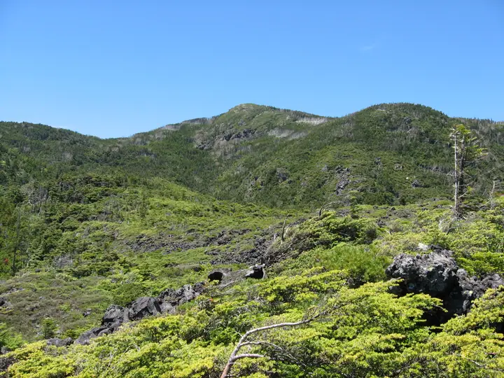
This is the southern summit of Kitayokodake, with open views south toward southern Yatsugatake and the Southern, Central and Northern Alps. It can be reached from the upper station of the Kita-Yatsugatake Ropeway via Tsuboniwa, with a steep climb just below the summit.
Yokodake at a glance
- Weather: The most settled day in the next 7 days is Wed, November 4: clear, gusts up to 7 m/s.
- Route: The shortest is Mount Kitayokodake Round Trip from Kita-Yatsugatake Ropeway Summit Station: about 2 h 14 min, 3.8 km, about 280 m of climbing.
Yokodake weather (hourly, 14 days)
Sunrise today 06:11, sunset 16:50
| Tue, 11/3 | Wed, 11/4 | Thu, 11/5 | Fri, 11/6 | Sat, 11/7 | Sun, 11/8 | Mon, 11/9 | Tue, 11/10 | Wed, 11/11 | Thu, 11/12 | Fri, 11/13 | Sat, 11/14 | Sun, 11/15 | Mon, 11/16 | Tue, 11/17 | |||||||||||||||||||||||||||||||||||||||||||||||||||||||||||||||||||||||
|---|---|---|---|---|---|---|---|---|---|---|---|---|---|---|---|---|---|---|---|---|---|---|---|---|---|---|---|---|---|---|---|---|---|---|---|---|---|---|---|---|---|---|---|---|---|---|---|---|---|---|---|---|---|---|---|---|---|---|---|---|---|---|---|---|---|---|---|---|---|---|---|---|---|---|---|---|---|---|---|---|---|---|---|---|---|
| Japan time | 15 | 17 | 19 | 21 | 23 | 1 | 3 | 5 | 7 | 9 | 11 | 13 | 15 | 18 | 21 | 0 | 3 | 6 | 9 | 12 | 15 | 18 | 21 | 0 | 3 | 6 | 9 | 12 | 15 | 18 | 21 | 0 | 3 | 6 | 9 | 12 | 15 | 18 | 21 | 0 | 3 | 6 | 9 | 12 | 15 | 18 | 21 | 0 | 3 | 6 | 9 | 15 | 21 | 3 | 9 | 15 | 21 | 3 | 9 | 15 | 21 | 3 | 9 | 15 | 21 | 3 | 9 | 15 | 21 | 3 | 9 | 15 | 21 | 3 | 9 | 15 | 21 | 3 | 9 | 15 | 21 | 3 | 9 | 15 | |
  |   |  | | | | | | | | | |   |   | |   | | |   |   |   |  | | |   | |  | | | | |   | | | | | | | | | | | | | | | | | | | | | | | | | |   |   | | |  | | | | | |   | | | | | | | | | | | |   | | | | | ||
| Temperature | °C | 6° | 1° | 0° | -1° | -1° | -1° | -1° | -2° | -1° | 4° | 7° | 9° | 7° | 3° | 2° | 3° | 3° | 2° | 6° | 9° | 8° | 5° | 4° | 3° | 3° | 4° | 8° | 10° | 10° | 3° | -1° | -3° | -5° | -6° | 0° | 2° | 1° | -5° | -6° | -5° | -5° | -5° | 2° | 6° | 4° | -2° | -2° | -2° | -2° | -1° | 2° | 4° | -2° | -3° | 2° | 4° | -1° | -3° | -2° | -1° | -6° | -6° | 1° | 4° | -5° | -3° | 0° | 1° | -6° | -5° | 3° | 6° | -2° | -2° | 5° | 5° | 2° | 3° | 8° | 5° | -2° | -5° | 1° | 4° |
| Precipitation | mm | 2.3 | 8 | 3.9 | 0.4 | 0.7 | 0.1 | 0.1 | 0.3 | 0.3 | 0.2 | 9 | 11 | 1.4 | 0.8 | ||||||||||||||||||||||||||||||||||||||||||||||||||||||||||||||||||||||
| New snow | cm | 0.2 | 0.2 | <.1 | |||||||||||||||||||||||||||||||||||||||||||||||||||||||||||||||||||||||||||||||||
| Snow depth | cm | 0 | 0 | 0 | 0 | 0 | 0 | 0 | 0 | 0 | 0 | 0 | 0 | 0 | 0 | 0 | 0 | 0 | 0 | 0 | 0 | 0 | 0 | 0 | 0 | 0 | 0 | 0 | 0 | 0 | 0 | 0 | 0 | 0 | 0 | 0 | 0 | 0 | 0 | 0 | 0 | 0 | 0 | 0 | 0 | 0 | 0 | 0 | 0 | 0 | 0 | 0 | 0 | 0 | 0 | 0 | 0 | 0 | 0 | 0 | 0 | 0 | 0 | 0 | 0 | 0 | 0 | 0 | 0 | 0 | 0 | 0 | 0 | 0 | 0 | 0 | 0 | 0 | 0 | 0 | 0 | 0 | 0 | 0 | 0 |
| Wind | m/s | 1 | 0 | 0 | 0 | 0 | 0 | 0 | 0 | 0 | 1 | 1 | 1 | 1 | 2 | 2 | 2 | 1 | 0 | 1 | 0 | 1 | 1 | 1 | 1 | 2 | 1 | 2 | 3 | 3 | 1 | 1 | 2 | 2 | 2 | 3 | 4 | 3 | 1 | 1 | 1 | 1 | 1 | 1 | 1 | 1 | 0 | 1 | 0 | 1 | 1 | 1 | 2 | 1 | 1 | 2 | 4 | 2 | 3 | 5 | 4 | 1 | 1 | 2 | 2 | 0 | 1 | 3 | 2 | 1 | 1 | 1 | 2 | 1 | 2 | 3 | 2 | 2 | 2 | 2 | 3 | 2 | 1 | 1 | 1 |
| Wind gusts | m/s | 7 | 6 | 4 | 4 | 5 | 5 | 4 | 4 | 4 | 5 | 6 | 7 | 7 | 10 | 11 | 11 | 11 | 10 | 7 | 6 | 10 | 9 | 8 | 9 | 10 | 10 | 11 | 12 | 13 | 11 | 10 | 11 | 12 | 12 | 14 | 15 | 14 | 11 | 8 | 8 | 8 | 8 | 7 | 7 | 8 | 6 | 7 | 8 | 9 | 9 | 9 | 11 | 7 | 5 | 8 | 17 | 14 | 15 | 21 | 23 | 17 | 8 | 8 | 11 | 9 | 8 | 11 | 13 | 10 | 7 | 6 | 7 | 7 | 8 | 10 | 14 | 12 | 16 | 13 | 13 | 13 | 8 | 5 | 7 |
| Wind dir. | ↓ | ↓ | ↓ | ↓ | ↓ | ↓ | ↓ | ↓ | ↓ | ↓ | ↓ | ↓ | ↓ | ↓ | ↓ | ↓ | ↓ | ↓ | ↓ | ↓ | ↓ | ↓ | ↓ | ↓ | ↓ | ↓ | ↓ | ↓ | ↓ | ↓ | ↓ | ↓ | ↓ | ↓ | ↓ | ↓ | ↓ | ↓ | ↓ | ↓ | ↓ | ↓ | ↓ | ↓ | ↓ | ↓ | ↓ | ↓ | ↓ | ↓ | ↓ | ↓ | ↓ | ↓ | ↓ | ↓ | ↓ | ↓ | ↓ | ↓ | ↓ | ↓ | ↓ | ↓ | ↓ | ↓ | ↓ | ↓ | ↓ | ↓ | ↓ | ↓ | ↓ | ↓ | ↓ | ↓ | ↓ | ↓ | ↓ | ↓ | ↓ | ↓ | ↓ | ↓ | |
Yokodake live cameras
Yokodake hiking routes
- Mount Kitayokodake Round Trip from Kita-Yatsugatake Ropeway Summit Station 3.8 km · Ascent 277 m 北八ヶ岳ロープウェイ山頂駅 (Aerialway station)
- Mount Kitayokodake, Mount Mitsudake and Mount Amaikeyama Loop 5.2 km · Ascent 416 m 北八ヶ岳ロープウェイ山頂駅 (Aerialway station)
- Mount Kitayokodake and Mount Shimagare Loop from Kitayatsugatake Ropeway Summit Station 7.9 km · Ascent 537 m 北八ヶ岳ロープウェイ山頂駅 (Aerialway station)
- Mount Kitayoko Return from Kitayatsugatake Ropeway Base Station 8.9 km · Ascent 751 m 北八ヶ岳登山口, 八ヶ岳ロープウェイ山麓駅 (Aerialway station) (parking)
Hiking times are estimates calculated from the terrain.
Huts, campsites and lodging near Yokodake
Mountain huts
- Kita-Yokodake Hut 2024: open all year · reservation required · sleeps 20
- Shimagaresanso 2026: open all year · reservation required · sleeps 20
- Futagoike Hutte 2026: open April 25–November 7 · reservation required · sleeps 40
- Ogawara Hutte temporarily closed
- Tateshinasancho Hutte 2026: open April 25–October 31 · reservation required · sleeps 33
Campsites
- 双子池キャンプ場
Yokodake facts
- Elevation
- 2,471 m
- Location
- Chino, Nagano
36.086130, 138.319534 - Volcano
- Active volcano (横岳)
- Website
- www.go-nagano.net
- Trail Map
- www.kitayatu.jp
- Access Information
- www.kitayatu.jp
- Wikipedia
- ja.wikipedia.org