
Yakedakehoppo
焼岳 (北峰)
Takayama, Gifu · Elevation 2,444 m
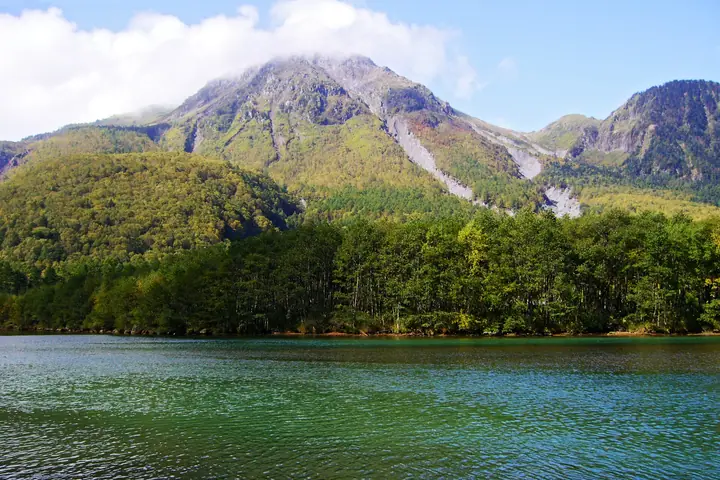
The 2,444 m north peak of the active Yake volcano lies in Takayama, Gifu, within Chubu-Sangaku National Park. The volcano as a whole straddles the boundary with Matsumoto, Nagano. The slightly higher south peak (2,455 m) has been closed since the 1962 steam eruption, so trails end at the north peak, the usual climbing objective. Approaches come from Kamikochi, Naka-no-yu and Shin-nakao Pass on the Nagano and Gifu sides. The volcano is continuously monitored, and entry restrictions vary with volcanic alert levels. The summit overlooks the Azusa River, Yarigatake and the Hotaka range.
Yakedakehoppo at a glance
- Weather: The most settled day in the next 7 days is Wed, November 4: clear, gusts up to 7 m/s. Fri, Nov 6, Sat, Nov 7: strong wind (gusts up to 19 m/s).
- Route: The shortest is Mount Yake to Kamikōchi Traverse from Shin-Nakanoyu: about 6 h 9 min, 10.4 km, about 910 m of climbing.
Yakedakehoppo weather (hourly, 14 days)
Sunrise today 06:14, sunset 16:53
| Tue, 11/3 | Wed, 11/4 | Thu, 11/5 | Fri, 11/6 | Sat, 11/7 | Sun, 11/8 | Mon, 11/9 | Tue, 11/10 | Wed, 11/11 | Thu, 11/12 | Fri, 11/13 | Sat, 11/14 | Sun, 11/15 | Mon, 11/16 | Tue, 11/17 | |||||||||||||||||||||||||||||||||||||||||||||||||||||||||||||||||||||||
|---|---|---|---|---|---|---|---|---|---|---|---|---|---|---|---|---|---|---|---|---|---|---|---|---|---|---|---|---|---|---|---|---|---|---|---|---|---|---|---|---|---|---|---|---|---|---|---|---|---|---|---|---|---|---|---|---|---|---|---|---|---|---|---|---|---|---|---|---|---|---|---|---|---|---|---|---|---|---|---|---|---|---|---|---|---|
| Japan time | 15 | 17 | 19 | 21 | 23 | 1 | 3 | 5 | 7 | 9 | 11 | 13 | 15 | 18 | 21 | 0 | 3 | 6 | 9 | 12 | 15 | 18 | 21 | 0 | 3 | 6 | 9 | 12 | 15 | 18 | 21 | 0 | 3 | 6 | 9 | 12 | 15 | 18 | 21 | 0 | 3 | 6 | 9 | 12 | 15 | 18 | 21 | 0 | 3 | 6 | 9 | 15 | 21 | 3 | 9 | 15 | 21 | 3 | 9 | 15 | 21 | 3 | 9 | 15 | 21 | 3 | 9 | 15 | 21 | 3 | 9 | 15 | 21 | 3 | 9 | 15 | 21 | 3 | 9 | 15 | 21 | 3 | 9 | 15 | |
  |   |   | | | | | | | |  | |   |   | |   | | |   | | | | | | | |   |   | | |   | |   |   |   |   | | | | | |  | | | | | | | | | | | | | | | | | |   | |  | | | | |   | | | | | | | | | | | | | |   | | | | ||
| Temperature | °C | 0° | -4° | -7° | -7° | -8° | -7° | -6° | -6° | -5° | 2° | 4° | 4° | 4° | 0° | 0° | 0° | 0° | 1° | 2° | 5° | 5° | 2° | 1° | 1° | 1° | 0° | 1° | 3° | 1° | -3° | -5° | -6° | -7° | -7° | -7° | -7° | -7° | -9° | -10° | -10° | -11° | -11° | -3° | -1° | -2° | -6° | -6° | -5° | -5° | -5° | -3° | -2° | -9° | -9° | -2° | -3° | -6° | -11° | -9° | -7° | -12° | -10° | -4° | -3° | -10° | -7° | -6° | -4° | -11° | -8° | -2° | -1° | -7° | -6° | 0° | 0° | -1° | 0° | 0° | -2° | -7° | -7° | -3° | -2° |
| Precipitation | mm | 2.9 | 10 | 8 | 5 | 0.4 | 0.3 | 3.0 | 2.8 | 0.6 | 1.0 | 0.2 | 0.1 | 0.2 | 0.7 | 0.8 | 0.8 | 0.7 | 0.2 | 0.2 | 0.3 | 0.2 | 4.1 | 6 | 2.2 | 0.2 | 0.2 | 1.6 | 0.5 | 8 | 8 | 4.7 | 1.3 | 0.4 | |||||||||||||||||||||||||||||||||||||||||||||||||||
| New snow | cm | <.1 | 0.1 | 0.4 | 0.8 | 0.8 | 0.7 | 0.2 | <.1 | <.1 | <.1 | 0.1 | 0.1 | <.1 | 0.1 | <.1 | 3.3 | 5.2 | 2.1 | 0.2 | 0.2 | 1.2 | <.1 | <.1 | <.1 | ||||||||||||||||||||||||||||||||||||||||||||||||||||||||||||
| Snow depth | cm | 0 | 0 | 0 | 0 | 0 | 0 | 0 | 0 | 0 | 0 | 0 | 0 | 0 | 0 | 0 | 0 | 0 | 0 | 0 | 0 | 0 | 0 | 0 | 0 | 0 | 0 | 0 | 0 | 0 | 0 | 0 | <1 | <1 | <1 | 2 | 2 | 2 | 2 | 2 | 2 | 2 | 2 | 1 | 1 | <1 | <1 | <1 | <1 | <1 | <1 | <1 | <1 | <1 | <1 | <1 | <1 | 3 | 7 | 8 | 7 | 7 | 7 | 7 | 6 | 6 | 6 | 7 | 6 | 6 | 6 | 6 | 5 | 5 | 5 | 4 | 3 | 2 | 2 | <1 | <1 | <1 | <1 | <1 | <1 |
| Wind | m/s | 3 | 0 | 1 | 1 | 1 | 1 | 0 | 1 | 1 | 1 | 1 | 2 | 2 | 1 | 2 | 1 | 2 | 0 | 1 | 1 | 2 | 0 | 0 | 1 | 1 | 2 | 4 | 5 | 5 | 3 | 4 | 5 | 5 | 5 | 5 | 5 | 4 | 3 | 2 | 1 | 1 | 1 | 1 | 2 | 1 | 1 | 0 | 0 | 1 | 1 | 1 | 2 | 1 | 2 | 2 | 5 | 2 | 6 | 3 | 2 | 0 | 0 | 1 | 2 | 1 | 1 | 2 | 2 | 0 | 0 | 1 | 1 | 0 | 0 | 1 | 1 | 2 | 1 | 3 | 4 | 1 | 0 | 1 | 1 |
| Wind gusts | m/s | 10 | 9 | 4 | 4 | 4 | 4 | 4 | 3 | 3 | 5 | 7 | 7 | 7 | 7 | 8 | 8 | 7 | 7 | 9 | 9 | 10 | 9 | 6 | 7 | 8 | 9 | 13 | 16 | 16 | 15 | 14 | 16 | 17 | 18 | 18 | 19 | 18 | 14 | 12 | 10 | 9 | 9 | 8 | 9 | 9 | 6 | 5 | 7 | 9 | 9 | 7 | 12 | 8 | 6 | 7 | 16 | 14 | 23 | 21 | 16 | 9 | 4 | 6 | 8 | 7 | 9 | 11 | 10 | 8 | 6 | 5 | 6 | 4 | 6 | 6 | 12 | 13 | 16 | 11 | 16 | 14 | 6 | 4 | 7 |
| Wind dir. | ↓ | ↓ | ↓ | ↓ | ↓ | ↓ | ↓ | ↓ | ↓ | ↓ | ↓ | ↓ | ↓ | ↓ | ↓ | ↓ | ↓ | ↓ | ↓ | ↓ | ↓ | ↓ | ↓ | ↓ | ↓ | ↓ | ↓ | ↓ | ↓ | ↓ | ↓ | ↓ | ↓ | ↓ | ↓ | ↓ | ↓ | ↓ | ↓ | ↓ | ↓ | ↓ | ↓ | ↓ | ↓ | ↓ | ↓ | ↓ | ↓ | ↓ | ↓ | ↓ | ↓ | ↓ | ↓ | ↓ | ↓ | ↓ | ↓ | ↓ | ↓ | ↓ | ↓ | ↓ | ↓ | ↓ | ↓ | ↓ | ↓ | ↓ | ↓ | ↓ | ↓ | ↓ | ↓ | ↓ | ↓ | ↓ | ↓ | ↓ | ↓ | ↓ | ↓ | ↓ | |
Yakedakehoppo live cameras
Yakedakehoppo hiking routes
- Mount Yake to Kamikōchi Traverse from Shin-Nakanoyu 10.4 km · Ascent 912 m Shin Nakanoyu Trailhead (parking) → Kamikochi (Bus stop)
- Mount Yakedake North Peak Return from Kamikochi via Yakedake Hut 12.6 km · Ascent 1,039 m Kamikochi (Bus stop)
Hiking times are estimates calculated from the terrain.
Huts, campsites and lodging near Yakedakehoppo
Mountain huts
- 焼岳小屋 2026: open June 15–October 15 · reservation required
- Nishiho Hut 2026: open all year · reservation required · sleeps 180
Campsites
- 合掌の森中尾キャンプ場
- 西穂山荘テント場
Lodging
- Taisyoike Hotel
- 中の湯温泉旅館
- 山の旅舎 中尾平
- Kamikouchi Onsen Hotel
- 貸別荘 奥飛ログハウス
Lists that include Yakedakehoppo
Yakedakehoppo facts
- Elevation
- 2,444 m
- Location
- Takayama, Gifu
36.228701, 137.589651 - National Park
- 中部山岳国立公園
- Volcano
- Active volcano (焼岳)
- Website
- www.kamikochi.or.jp
- Wikipedia
- ja.wikipedia.org