
Mt. Kurobebessan (South Peak)
黒部別山 南峰
Tateyama, Toyama · Elevation 2,300 m
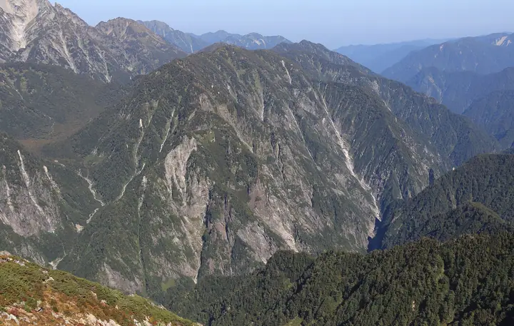
The South Peak of Mount Kurobebessan is a 2,300-meter summit at the southern end of Kurobebessan in the Tateyama Range of the Hida Mountains, in Tateyama, Toyama Prefecture. The wider mountain comprises three peaks—south, main, and north—and its eastern face presents steep rock walls carved by the Kurobe River with no maintained hiking trails. It lies within Chubu Sangaku National Park.
Mt. Kurobebessan (South Peak) at a glance
- Weather: The most settled day in the next 7 days is Wed, November 4: clear, gusts up to 6 m/s. Fri, Nov 6, Sat, Nov 7: strong wind (gusts up to 21 m/s).
Mt. Kurobebessan (South Peak) weather (hourly, 14 days)
Sunrise today 06:14, sunset 16:52
| Tue, 11/3 | Wed, 11/4 | Thu, 11/5 | Fri, 11/6 | Sat, 11/7 | Sun, 11/8 | Mon, 11/9 | Tue, 11/10 | Wed, 11/11 | Thu, 11/12 | Fri, 11/13 | Sat, 11/14 | Sun, 11/15 | Mon, 11/16 | Tue, 11/17 | |||||||||||||||||||||||||||||||||||||||||||||||||||||||||||||||||||||||
|---|---|---|---|---|---|---|---|---|---|---|---|---|---|---|---|---|---|---|---|---|---|---|---|---|---|---|---|---|---|---|---|---|---|---|---|---|---|---|---|---|---|---|---|---|---|---|---|---|---|---|---|---|---|---|---|---|---|---|---|---|---|---|---|---|---|---|---|---|---|---|---|---|---|---|---|---|---|---|---|---|---|---|---|---|---|
| Japan time | 15 | 17 | 19 | 21 | 23 | 1 | 3 | 5 | 7 | 9 | 11 | 13 | 15 | 18 | 21 | 0 | 3 | 6 | 9 | 12 | 15 | 18 | 21 | 0 | 3 | 6 | 9 | 12 | 15 | 18 | 21 | 0 | 3 | 6 | 9 | 12 | 15 | 18 | 21 | 0 | 3 | 6 | 9 | 12 | 15 | 18 | 21 | 0 | 3 | 6 | 9 | 15 | 21 | 3 | 9 | 15 | 21 | 3 | 9 | 15 | 21 | 3 | 9 | 15 | 21 | 3 | 9 | 15 | 21 | 3 | 9 | 15 | 21 | 3 | 9 | 15 | 21 | 3 | 9 | 15 | 21 | 3 | 9 | 15 | |
 |   | |  | | | | |   | | | | |   | |   | | |   | |   | | | | | | | | |   | |   | | |   | | | | | |   | | | |   |   | | | | | | | |   | | | | | | | |  | | | | | |   | | | | | | | | | | | |   | | | | | ||
| Temperature | °C | 2° | -3° | -6° | -7° | -7° | -6° | -5° | -5° | -4° | 3° | 6° | 7° | 6° | 0° | 1° | 2° | 2° | 2° | 5° | 7° | 9° | 4° | 4° | 4° | 3° | 3° | 3° | 2° | 1° | -1° | -3° | -4° | -6° | -7° | -7° | -6° | -7° | -9° | -10° | -12° | -13° | -11° | -2° | -1° | -2° | -5° | -5° | -5° | -4° | -4° | -2° | -2° | -11° | -12° | -1° | 0° | -4° | -9° | -7° | -6° | -8° | -11° | -3° | -2° | -11° | -5° | -4° | -3° | -10° | -10° | 1° | 2° | -8° | -7° | 3° | 2° | 2° | 1° | 2° | -2° | -7° | -9° | -1° | 0° |
| Precipitation | mm | 2.2 | 10 | 8 | 5 | 1.6 | 1.1 | 1.4 | 4.1 | 2.1 | 2.3 | 0.9 | 2.3 | 1.8 | 4.6 | 3.6 | 3.7 | 3.4 | 1.9 | 1.0 | 0.5 | 0.4 | 1.6 | 2.0 | 0.2 | 0.6 | 4.9 | 11 | 8 | 2.7 | 2.4 | 5 | 0.3 | 0.7 | 8 | 8 | 6 | 9 | 4.2 | ||||||||||||||||||||||||||||||||||||||||||||||
| New snow | cm | 0.2 | 0.9 | 4.3 | 3.5 | 3.6 | 3.3 | 1.9 | 1.0 | 0.5 | <.1 | <.1 | <.1 | 0.4 | 1.6 | 1.9 | 0.2 | 0.6 | <.1 | 4.8 | 10 | 8.2 | 2.7 | <.1 | 2.3 | 4.7 | 0.3 | 2.1 | 3.3 | ||||||||||||||||||||||||||||||||||||||||||||||||||||||||
| Snow depth | cm | 0 | 0 | 0 | 0 | 0 | 0 | 0 | 0 | 0 | 0 | 0 | 0 | 0 | 0 | 0 | 0 | 0 | 0 | 0 | 0 | 0 | 0 | 0 | 0 | 0 | 0 | 0 | 0 | 0 | 0 | <1 | 4 | 6 | 9 | 12 | 13 | 14 | 14 | 13 | 13 | 13 | 12 | 12 | 12 | 11 | 11 | 11 | 11 | 12 | 14 | 14 | 12 | 12 | 12 | 12 | 11 | 14 | 23 | 29 | 30 | 29 | 28 | 28 | 27 | 26 | 28 | 31 | 30 | 30 | 29 | 29 | 28 | 28 | 28 | 27 | 25 | 24 | 22 | 20 | 19 | 21 | 20 | 20 | 20 |
| Wind | m/s | 1 | 1 | 1 | 1 | 1 | 1 | 0 | 0 | 0 | 1 | 0 | 1 | 1 | 1 | 2 | 0 | 0 | 1 | 2 | 3 | 3 | 0 | 1 | 2 | 1 | 2 | 3 | 4 | 3 | 4 | 4 | 3 | 4 | 4 | 4 | 5 | 3 | 2 | 2 | 2 | 1 | 1 | 1 | 2 | 0 | 1 | 1 | 1 | 1 | 2 | 2 | 1 | 1 | 1 | 1 | 2 | 3 | 7 | 4 | 2 | 1 | 1 | 1 | 1 | 1 | 2 | 2 | 1 | 1 | 1 | 1 | 0 | 1 | 1 | 1 | 1 | 2 | 2 | 1 | 3 | 1 | 0 | 0 | 0 |
| Wind gusts | m/s | 10 | 8 | 8 | 8 | 8 | 7 | 6 | 6 | 5 | 6 | 6 | 6 | 6 | 7 | 9 | 9 | 6 | 7 | 12 | 15 | 14 | 11 | 8 | 11 | 10 | 11 | 14 | 16 | 19 | 17 | 17 | 16 | 18 | 18 | 18 | 21 | 20 | 16 | 13 | 12 | 12 | 11 | 10 | 9 | 9 | 9 | 9 | 10 | 11 | 11 | 11 | 11 | 8 | 7 | 7 | 12 | 14 | 28 | 30 | 19 | 11 | 6 | 7 | 9 | 7 | 11 | 11 | 11 | 9 | 8 | 6 | 6 | 6 | 8 | 9 | 13 | 15 | 18 | 14 | 15 | 14 | 7 | 4 | 5 |
| Wind dir. | ↓ | ↓ | ↓ | ↓ | ↓ | ↓ | ↓ | ↓ | ↓ | ↓ | ↓ | ↓ | ↓ | ↓ | ↓ | ↓ | ↓ | ↓ | ↓ | ↓ | ↓ | ↓ | ↓ | ↓ | ↓ | ↓ | ↓ | ↓ | ↓ | ↓ | ↓ | ↓ | ↓ | ↓ | ↓ | ↓ | ↓ | ↓ | ↓ | ↓ | ↓ | ↓ | ↓ | ↓ | ↓ | ↓ | ↓ | ↓ | ↓ | ↓ | ↓ | ↓ | ↓ | ↓ | ↓ | ↓ | ↓ | ↓ | ↓ | ↓ | ↓ | ↓ | ↓ | ↓ | ↓ | ↓ | ↓ | ↓ | ↓ | ↓ | ↓ | ↓ | ↓ | ↓ | ↓ | ↓ | ↓ | ↓ | ↓ | ↓ | ↓ | ↓ | ↓ | ↓ | |
Huts, campsites and lodging near Mt. Kurobebessan (South Peak)
Mountain huts
- 真砂沢口小屋
- 真砂沢ロッジ 2026: open July 17–October 11 · reservation required · sleeps 16
- Kuranosuke Sanso 2026: open July 16–September 30 · reservation required · sleeps 40
- Sennin-ike Hutte 2026: open July 18–October 11 · reservation required · sleeps 70
- Tsurugisawa-goya 2026: open July 10–October 4 · reservation required · sleeps 56
Campsites
- Tsurugisawa Campsite
- Kurojon
Mt. Kurobebessan (South Peak) facts
- Elevation
- 2,300 m
- Location
- Tateyama, Toyama
36.599801, 137.662591 - National Park
- 中部山岳国立公園
- Wikipedia
- ja.wikipedia.org