
Mount Jiigatake (Central Peak)
爺ヶ岳
Ōmachi-shi, Nagano · Elevation 2,670 m
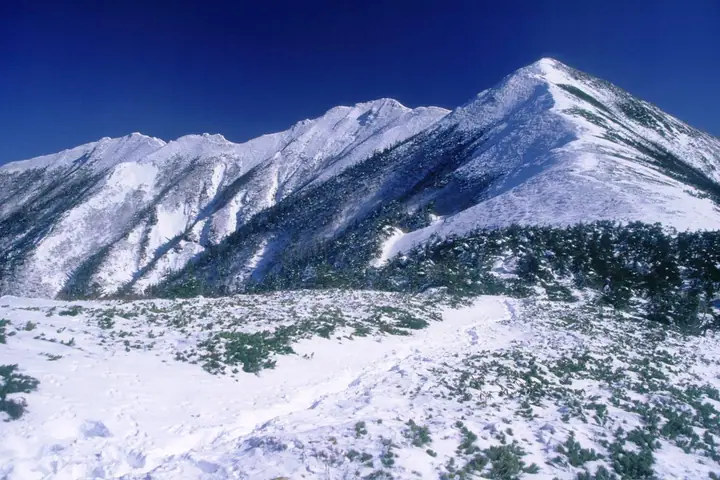
Jiigatake Central Peak is the highest of the three summits of Mt. Jiigatake at 2,670 m, on the border of Toyama and Ōmachi (Nagano), in the southern Ushiro-Tateyama Range. It lies within Chūbu-Sangaku National Park, with the south, central, and north peaks forming a graceful ridgeline. The peak is a key way-station on the Kashiwabara-shindō traverse to Kashimayari, and is included in the 300 Famous Mountains of Japan and the 100 Famous Mountains of Shinshū.
Mount Jiigatake (Central Peak) at a glance
- Weather: The most settled day in the next 7 days is Wed, November 4: clear, gusts up to 6 m/s. Fri, Nov 6, Sat, Nov 7: strong wind (gusts up to 18 m/s).
- Route: The shortest is Mount Jiigatake and Mount Kashima Yarigatake Out-and-Back via Kashiwabara New Trail: about 14 h 47 min, 22.6 km, about 2,290 m of climbing.
Mount Jiigatake (Central Peak) weather (hourly, 14 days)
Sunrise today 06:14, sunset 16:52
| Tue, 11/3 | Wed, 11/4 | Thu, 11/5 | Fri, 11/6 | Sat, 11/7 | Sun, 11/8 | Mon, 11/9 | Tue, 11/10 | Wed, 11/11 | Thu, 11/12 | Fri, 11/13 | Sat, 11/14 | Sun, 11/15 | Mon, 11/16 | Tue, 11/17 | |||||||||||||||||||||||||||||||||||||||||||||||||||||||||||||||||||||||
|---|---|---|---|---|---|---|---|---|---|---|---|---|---|---|---|---|---|---|---|---|---|---|---|---|---|---|---|---|---|---|---|---|---|---|---|---|---|---|---|---|---|---|---|---|---|---|---|---|---|---|---|---|---|---|---|---|---|---|---|---|---|---|---|---|---|---|---|---|---|---|---|---|---|---|---|---|---|---|---|---|---|---|---|---|---|
| Japan time | 15 | 17 | 19 | 21 | 23 | 1 | 3 | 5 | 7 | 9 | 11 | 13 | 15 | 18 | 21 | 0 | 3 | 6 | 9 | 12 | 15 | 18 | 21 | 0 | 3 | 6 | 9 | 12 | 15 | 18 | 21 | 0 | 3 | 6 | 9 | 12 | 15 | 18 | 21 | 0 | 3 | 6 | 9 | 12 | 15 | 18 | 21 | 0 | 3 | 6 | 9 | 15 | 21 | 3 | 9 | 15 | 21 | 3 | 9 | 15 | 21 | 3 | 9 | 15 | 21 | 3 | 9 | 15 | 21 | 3 | 9 | 15 | 21 | 3 | 9 | 15 | 21 | 3 | 9 | 15 | 21 | 3 | 9 | 15 | |
  |   | |  | | | | | |  | | | |   |   | | | |   | |   | | |   | | | | | |   | | |   | |   | | | | | | | | | |   | |   | | | | |   | |   | | | | | | | |  | | | | |   |   | | | | | | | | | | | | |   | | | | ||
| Temperature | °C | 1° | -4° | -6° | -9° | -9° | -8° | -8° | -7° | -6° | -1° | 2° | 4° | 3° | -2° | -2° | -2° | -1° | -1° | 1° | 3° | 6° | 2° | 2° | 1° | 0° | 0° | 2° | 2° | 2° | -2° | -4° | -5° | -7° | -8° | -8° | -8° | -8° | -9° | -11° | -12° | -13° | -12° | -4° | -1° | -3° | -6° | -6° | -6° | -6° | -6° | -3° | -3° | -10° | -11° | -3° | 0° | -5° | -10° | -7° | -6° | -10° | -12° | -5° | -3° | -12° | -7° | -6° | -4° | -11° | -12° | -3° | 1° | -9° | -9° | 0° | 1° | -2° | -2° | 0° | -2° | -7° | -10° | -4° | -2° |
| Precipitation | mm | 0.1 | 1.8 | 10 | 9 | 6 | 2.2 | 0.1 | 0.1 | 1.1 | 0.8 | 2.3 | 1.0 | 1.0 | 0.3 | 1.0 | 0.9 | 2.5 | 2.1 | 2.4 | 2.4 | 1.5 | 0.8 | 0.4 | 0.2 | 1.2 | 1.9 | 0.2 | 0.3 | 0.6 | 2.8 | 8 | 7 | 1.5 | 1.0 | 3.3 | 0.2 | 0.5 | 10 | 9 | 3.0 | 5.0 | 2.5 | ||||||||||||||||||||||||||||||||||||||||||
| New snow | cm | <.1 | 0.3 | 1.5 | 1.7 | 2.2 | 2.2 | 1.4 | 0.7 | 0.4 | <.1 | <.1 | <.1 | 0.2 | 1.0 | 1.3 | <.1 | <.1 | 0.3 | 1.9 | 6.6 | 6.9 | 1.4 | <.1 | 0.9 | 2.3 | <.1 | 0.6 | 1.1 | ||||||||||||||||||||||||||||||||||||||||||||||||||||||||
| Snow depth | cm | 0 | 0 | 0 | 0 | 0 | 0 | 0 | 0 | 0 | 0 | 0 | 0 | 0 | 0 | 0 | 0 | 0 | 0 | 0 | 0 | 0 | 0 | 0 | 0 | 0 | 0 | 0 | 0 | 0 | 0 | <1 | 1 | 3 | 4 | 6 | 6 | 6 | 6 | 6 | 6 | 6 | 6 | 6 | 6 | 5 | 5 | 5 | 5 | 5 | 7 | 6 | 5 | 5 | 5 | 5 | 4 | 5 | 10 | 15 | 15 | 14 | 13 | 13 | 12 | 12 | 12 | 14 | 13 | 12 | 12 | 12 | 11 | 11 | 11 | 11 | 9 | 9 | 8 | 7 | 6 | 7 | 7 | 7 | 7 |
| Wind | m/s | 0 | 1 | 1 | 1 | 1 | 1 | 1 | 0 | 0 | 1 | 1 | 1 | 2 | 0 | 1 | 0 | 0 | 0 | 1 | 0 | 1 | 1 | 0 | 1 | 1 | 1 | 1 | 3 | 2 | 2 | 2 | 1 | 2 | 1 | 2 | 4 | 3 | 2 | 2 | 2 | 2 | 2 | 1 | 1 | 0 | 0 | 1 | 1 | 1 | 1 | 1 | 1 | 1 | 1 | 1 | 1 | 1 | 4 | 2 | 1 | 1 | 1 | 1 | 1 | 1 | 2 | 1 | 0 | 1 | 1 | 0 | 0 | 1 | 1 | 0 | 0 | 1 | 2 | 1 | 1 | 1 | 0 | 0 | 1 |
| Wind gusts | m/s | 7 | 6 | 6 | 7 | 7 | 7 | 6 | 5 | 4 | 4 | 6 | 6 | 6 | 5 | 5 | 5 | 4 | 4 | 7 | 9 | 8 | 6 | 5 | 7 | 6 | 7 | 10 | 14 | 15 | 13 | 13 | 13 | 14 | 14 | 14 | 18 | 18 | 14 | 12 | 11 | 11 | 11 | 9 | 7 | 7 | 6 | 6 | 6 | 7 | 7 | 7 | 8 | 6 | 6 | 6 | 7 | 10 | 22 | 24 | 16 | 8 | 6 | 6 | 6 | 7 | 9 | 9 | 8 | 7 | 6 | 5 | 5 | 6 | 6 | 6 | 7 | 8 | 10 | 10 | 13 | 10 | 6 | 4 | 6 |
| Wind dir. | ↓ | ↓ | ↓ | ↓ | ↓ | ↓ | ↓ | ↓ | ↓ | ↓ | ↓ | ↓ | ↓ | ↓ | ↓ | ↓ | ↓ | ↓ | ↓ | ↓ | ↓ | ↓ | ↓ | ↓ | ↓ | ↓ | ↓ | ↓ | ↓ | ↓ | ↓ | ↓ | ↓ | ↓ | ↓ | ↓ | ↓ | ↓ | ↓ | ↓ | ↓ | ↓ | ↓ | ↓ | ↓ | ↓ | ↓ | ↓ | ↓ | ↓ | ↓ | ↓ | ↓ | ↓ | ↓ | ↓ | ↓ | ↓ | ↓ | ↓ | ↓ | ↓ | ↓ | ↓ | ↓ | ↓ | ↓ | ↓ | ↓ | ↓ | ↓ | ↓ | ↓ | ↓ | ↓ | ↓ | ↓ | ↓ | ↓ | ↓ | ↓ | ↓ | ↓ | ||
Mount Jiigatake (Central Peak) hiking routes
- Mount Jiigatake and Mount Kashima Yarigatake Out-and-Back via Kashiwabara New Trail 22.6 km · Ascent 2,295 m 柏原新道登山口 (parking)
- Mount Kashima-Yarigatake–Mount Goryu Happo Kiretto Traverse 24.2 km · Ascent 2,860 m 柏原新道登山口 (parking) → 五竜テレキャビン アルプス平駅 (Aerialway station)
Hiking times are estimates calculated from the terrain.
Huts, campsites and lodging near Mount Jiigatake (Central Peak)
Mountain huts
- Taneike Sanso 2026: open July 1–October 17 · reservation required · sleeps 90
- Tsumetaike Sanso 2026: open July 1–October 17 · reservation required · sleeps 120
- Shinkoshi-Sanso 2026: open July 15–September 26 · reservation required · sleeps 35
Campsites
- 種池山荘テント場
- 冷池山荘テント場
Lists that include Mount Jiigatake (Central Peak)
Japan's 300 Famous Mountains · 100 Famous Mountains of Flowers · Japan's 100 Highest Mountains · New Japan 100 Famous Mountains · Koshinetsu 100 Famous Mountains · Shinshu 100 Famous Mountains · 100 Mountains of Toyama · Shinshu Mountain Cards · Elevations of 1003 Mountains of Japan · 1000 Mountains of Japan
Mount Jiigatake (Central Peak) facts
- Also known as
- 三ツ丸 · 五六ヶ岳 · 後立山(ごりゅうさん) · 本峰 · 栂山 · 栂谷ノ峰 · 棒小屋ノ峰 · 爺子岳 · 爺岳 · 白沢ノ頭
- Elevation
- 2,670 m
- Location
- Ōmachi-shi, Nagano
36.588315, 137.750927 - National Park
- 中部山岳国立公園
- Website
- kanko-omachi.gr.jp
- Access Information
- kanko-omachi.gr.jp
- Wikipedia
- ja.wikipedia.org