
Mt. Karamatsudake
唐松岳
Kurobe, Toyama / Hakuba, Nagano · Elevation 2,696 m
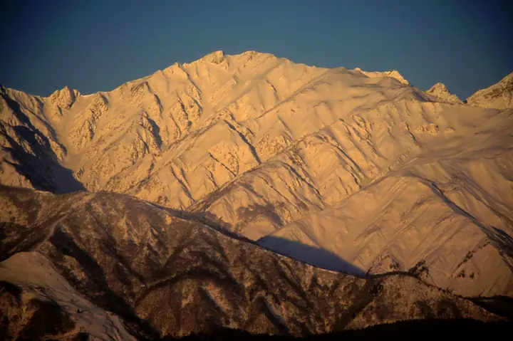
Karamatsu-dake (2,696 m) stands on the border of Kurobe City (Toyama) and Hakuba Village (Nagano), at the junction of the Ushiro-Tateyama main ridge and Happō-One in the Hida Range of the Northern Alps. It is included in the 300 Famous Mountains and 100 Highest Mountains of Japan, and lies within Chūbu Sangaku National Park. The Happō-One approach — past the mirror-still Happō Pond with its reflections of the Hakuba Three Peaks — is regarded as a classic introductory route to the Northern Alps, while the Karamatsu-zawa snowfield just below the summit was certified in 2019 as Japan's seventh recognized glacier.
Mt. Karamatsudake at a glance
- Weather: The most settled day in the next 7 days is Wed, November 4: clear, gusts up to 6 m/s. Fri, Nov 6, Sat, Nov 7: strong wind (gusts up to 18 m/s).
- Route: The shortest is Happo-one Ridge to Karamatsudake Chojo Sanso Out-and-Back: about 6 h 5 min, 9.9 km, about 860 m of climbing.
Mt. Karamatsudake weather (hourly, 14 days)
Sunrise today 06:14, sunset 16:51
| Tue, 11/3 | Wed, 11/4 | Thu, 11/5 | Fri, 11/6 | Sat, 11/7 | Sun, 11/8 | Mon, 11/9 | Tue, 11/10 | Wed, 11/11 | Thu, 11/12 | Fri, 11/13 | Sat, 11/14 | Sun, 11/15 | Mon, 11/16 | Tue, 11/17 | |||||||||||||||||||||||||||||||||||||||||||||||||||||||||||||||||||||||
|---|---|---|---|---|---|---|---|---|---|---|---|---|---|---|---|---|---|---|---|---|---|---|---|---|---|---|---|---|---|---|---|---|---|---|---|---|---|---|---|---|---|---|---|---|---|---|---|---|---|---|---|---|---|---|---|---|---|---|---|---|---|---|---|---|---|---|---|---|---|---|---|---|---|---|---|---|---|---|---|---|---|---|---|---|---|
| Japan time | 21 | 23 | 1 | 3 | 5 | 7 | 9 | 11 | 13 | 15 | 17 | 19 | 21 | 0 | 3 | 6 | 9 | 12 | 15 | 18 | 21 | 0 | 3 | 6 | 9 | 12 | 15 | 18 | 21 | 0 | 3 | 6 | 9 | 12 | 15 | 18 | 21 | 0 | 3 | 6 | 9 | 12 | 15 | 18 | 21 | 0 | 3 | 6 | 9 | 12 | 15 | 21 | 3 | 9 | 15 | 21 | 3 | 9 | 15 | 21 | 3 | 9 | 15 | 21 | 3 | 9 | 15 | 21 | 3 | 9 | 15 | 21 | 3 | 9 | 15 | 21 | 3 | 9 | 15 | 21 | 3 | 9 | 15 | 21 | |
  |   | | |  |   |  | | | | | |   |   | |   |   | |   | | | | | |   | | | |   | |   | |   | | | | | | | | | |   | |   | | | | | | | | | | | | | | | | | | | | | |   | |  | | | | | | | | | |   | | | | | | ||
| Temperature | °C | -9° | -9° | -9° | -8° | -7° | -5° | 0° | 2° | 4° | 3° | 0° | -1° | -1° | -1° | 0° | 0° | 3° | 6° | 5° | 4° | 3° | 1° | 2° | 1° | 2° | 1° | 0° | -2° | -3° | -4° | -6° | -7° | -7° | -7° | -8° | -9° | -9° | -11° | -11° | -11° | -5° | -2° | -3° | -7° | -6° | -6° | -5° | -4° | -1° | 0° | -2° | -8° | -11° | -3° | 0° | -5° | -10° | -7° | -6° | -9° | -12° | -5° | -3° | -12° | -6° | -5° | -4° | -11° | -14° | -2° | 1° | -8° | -8° | 0° | 1° | 0° | -1° | 0° | -3° | -7° | -10° | -4° | -1° | -8° |
| Precipitation | mm | 3.0 | 9 | 6 | 1.1 | 0.3 | 2.6 | 0.1 | 9 | 3.6 | 1.0 | 1.5 | 1.4 | 2.8 | 2.2 | 2.4 | 3.0 | 2.7 | 3.3 | 2.5 | 1.9 | 0.6 | 0.5 | 0.2 | 0.2 | 4.9 | 10 | 9 | 2.8 | 0.1 | 2.0 | 6 | 0.3 | 0.5 | 8 | 8 | 6 | 7 | 2.3 | ||||||||||||||||||||||||||||||||||||||||||||||
| New snow | cm | 0.5 | 1.6 | 2.8 | 2.6 | 3.2 | 2.4 | 1.9 | 0.6 | 0.5 | 0.1 | <.1 | <.1 | <.1 | <.1 | <.1 | 4.1 | 9.8 | 9.3 | 2.8 | 0.1 | <.1 | 1.9 | 5.4 | 0.2 | 0.2 | 0.8 | ||||||||||||||||||||||||||||||||||||||||||||||||||||||||||
| Snow depth | cm | 0 | 0 | 0 | 0 | 0 | 0 | 0 | 0 | 0 | 0 | 0 | 0 | 0 | 0 | 0 | 0 | 0 | 0 | 0 | 0 | 0 | 0 | 0 | 0 | 0 | 0 | 0 | 0 | <1 | 2 | 4 | 7 | 9 | 10 | 12 | 12 | 12 | 12 | 12 | 11 | 11 | 10 | 10 | 10 | 10 | 10 | 11 | 12 | 12 | 12 | 10 | 9 | 9 | 9 | 7 | 10 | 16 | 23 | 23 | 22 | 22 | 21 | 20 | 19 | 20 | 24 | 23 | 22 | 22 | 22 | 20 | 20 | 20 | 20 | 17 | 16 | 15 | 13 | 10 | 10 | 10 | 10 | 9 | 9 |
| Wind | m/s | 1 | 1 | 1 | 1 | 0 | 0 | 2 | 2 | 1 | 2 | 0 | 1 | 1 | 0 | 0 | 0 | 0 | 1 | 1 | 0 | 0 | 1 | 1 | 1 | 2 | 3 | 2 | 3 | 2 | 2 | 2 | 2 | 2 | 3 | 3 | 2 | 2 | 2 | 2 | 1 | 0 | 0 | 0 | 0 | 0 | 0 | 1 | 1 | 1 | 1 | 1 | 0 | 0 | 1 | 1 | 1 | 4 | 4 | 2 | 1 | 1 | 0 | 0 | 1 | 2 | 1 | 1 | 1 | 1 | 0 | 0 | 0 | 1 | 0 | 0 | 1 | 1 | 1 | 2 | 1 | 0 | 0 | 0 | 0 |
| Wind gusts | m/s | 8 | 7 | 6 | 6 | 6 | 5 | 6 | 6 | 6 | 6 | 6 | 6 | 6 | 6 | 5 | 8 | 8 | 6 | 7 | 6 | 9 | 10 | 13 | 11 | 12 | 16 | 17 | 16 | 16 | 15 | 13 | 15 | 15 | 18 | 18 | 18 | 14 | 12 | 12 | 12 | 9 | 7 | 6 | 6 | 6 | 7 | 9 | 9 | 9 | 11 | 10 | 6 | 5 | 5 | 10 | 12 | 25 | 26 | 20 | 11 | 6 | 6 | 7 | 7 | 10 | 10 | 11 | 9 | 7 | 6 | 5 | 5 | 6 | 6 | 9 | 11 | 12 | 11 | 14 | 14 | 7 | 4 | 4 | 5 |
| Wind dir. | ↓ | ↓ | ↓ | ↓ | ↓ | ↓ | ↓ | ↓ | ↓ | ↓ | ↓ | ↓ | ↓ | ↓ | ↓ | ↓ | ↓ | ↓ | ↓ | ↓ | ↓ | ↓ | ↓ | ↓ | ↓ | ↓ | ↓ | ↓ | ↓ | ↓ | ↓ | ↓ | ↓ | ↓ | ↓ | ↓ | ↓ | ↓ | ↓ | ↓ | ↓ | ↓ | ↓ | ↓ | ↓ | ↓ | ↓ | ↓ | ↓ | ↓ | ↓ | ↓ | ↓ | ↓ | ↓ | ↓ | ↓ | ↓ | ↓ | ↓ | ↓ | ↓ | ↓ | ↓ | ↓ | ↓ | ↓ | ↓ | ↓ | ↓ | ↓ | ↓ | ↓ | ↓ | ↓ | ↓ | ↓ | ↓ | ↓ | ↓ | ↓ | ↓ | ↓ | ↓ | |
Mt. Karamatsudake hiking routes
- Happo-one Ridge to Karamatsudake Chojo Sanso Out-and-Back 9.9 km · Ascent 863 m グラートクワッドリフト 頂上駅 (Aerialway station)
- Mount Karamatsu Out-and-Back via Happo-one Ridge 10.2 km · Ascent 958 m グラートクワッドリフト 頂上駅 (Aerialway station)
- Mount Karamatsu and Mount Goryu Traverse: Happoike Sanso to Alps-daira Station 17.7 km · Ascent 1,751 m グラートクワッドリフト 頂上駅 (Aerialway station)
Hiking times are estimates calculated from the terrain.
Huts, campsites and lodging near Mt. Karamatsudake
Mountain huts
- 唐松岳頂上山荘 2026: open June 27–October 13 · reservation required · sleeps 350
- Goryusanso 2026: open June 20–October 12 · reservation required · sleeps 250
- Tengu Sanso 2026: open July 1–September 23 · reservation required · sleeps 90
- Happoike Sanso 2026: open all year · reservation required · sleeps 50
- Gakiyama Hinangoya temporarily closed
Campsites
- 唐松岳頂上山荘 テント場
Lists that include Mt. Karamatsudake
Japan's 300 Famous Mountains · Japan's 100 Highest Mountains · New Japan 100 Famous Mountains · Koshinetsu 100 Famous Mountains · Shinshu 100 Famous Mountains · 100 Mountains of Toyama · Shinshu Mountain Cards · Elevations of 1003 Mountains of Japan · 1000 Mountains of Japan
Mt. Karamatsudake facts
- Also known as
- 赤鬼岳 · 餓鬼岳 · ガキ谷山 · 上犬ヶ嶽
- Elevation
- 2,696 m
- Location
- Kurobe, Toyama / Hakuba, Nagano
36.687237, 137.754688 - National Park
- 中部山岳国立公園
- Website
- www.vill.hakuba.nagano.jp
- Trail Map
- www.happo-one.jp (PDF)
- Wikipedia
- ja.wikipedia.org