
Mount Kashimayari
鹿島槍ヶ岳
Ōmachi-shi, Nagano · Elevation 2,889 m
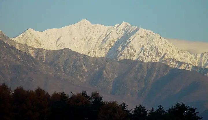
Mount Kashimayari is a 2,889 m peak straddling Kurobe (Toyama) and Ōmachi (Nagano), the southern anchor of the Ushiro-Tateyama Range within Chūbu-Sangaku National Park. Its graceful twin summits, the South Peak (2,889 m) and North Peak (2,842 m), are connected by the characteristic suspended ridge known as the tsuriono. The Kakunesato snowfield on its northeast face was officially recognized as one of Japan's few glaciers in 2018. It is one of the Hyakumeizan and Hyakukōzan.
Mount Kashimayari at a glance
- Weather: The most settled day in the next 7 days is Wed, November 4: clear, gusts up to 6 m/s. Fri, Nov 6, Sat, Nov 7: strong wind (gusts up to 18 m/s).
- Route: The shortest is Mount Jiigatake and Mount Kashima Yarigatake Out-and-Back via Kashiwabara New Trail: about 14 h 47 min, 22.6 km, about 2,290 m of climbing.
Mount Kashimayari weather (hourly, 14 days)
Sunrise today 06:14, sunset 16:52
| Tue, 11/3 | Wed, 11/4 | Thu, 11/5 | Fri, 11/6 | Sat, 11/7 | Sun, 11/8 | Mon, 11/9 | Tue, 11/10 | Wed, 11/11 | Thu, 11/12 | Fri, 11/13 | Sat, 11/14 | Sun, 11/15 | Mon, 11/16 | Tue, 11/17 | |||||||||||||||||||||||||||||||||||||||||||||||||||||||||||||||||||||||
|---|---|---|---|---|---|---|---|---|---|---|---|---|---|---|---|---|---|---|---|---|---|---|---|---|---|---|---|---|---|---|---|---|---|---|---|---|---|---|---|---|---|---|---|---|---|---|---|---|---|---|---|---|---|---|---|---|---|---|---|---|---|---|---|---|---|---|---|---|---|---|---|---|---|---|---|---|---|---|---|---|---|---|---|---|---|
| Japan time | 21 | 23 | 1 | 3 | 5 | 7 | 9 | 11 | 13 | 15 | 17 | 19 | 21 | 0 | 3 | 6 | 9 | 12 | 15 | 18 | 21 | 0 | 3 | 6 | 9 | 12 | 15 | 18 | 21 | 0 | 3 | 6 | 9 | 12 | 15 | 18 | 21 | 0 | 3 | 6 | 9 | 12 | 15 | 18 | 21 | 0 | 3 | 6 | 9 | 12 | 15 | 21 | 3 | 9 | 15 | 21 | 3 | 9 | 15 | 21 | 3 | 9 | 15 | 21 | 3 | 9 | 15 | 21 | 3 | 9 | 15 | 21 | 3 | 9 | 15 | 21 | 3 | 9 | 15 | 21 | 3 | 9 | 15 | 21 | |
  |   | | |  |   |  | | | | | |   |   | |   |   | |   | | | | | |   | | | |   | |   | |   | | | | | | | | | |   | |   | | | | | | | | | | | | | | | | | | | | | |   | |  | | | | | | | | | |   | | | | | | ||
| Temperature | °C | -11° | -11° | -10° | -9° | -9° | -6° | -1° | 1° | 3° | 2° | -2° | -2° | -2° | -2° | -2° | -1° | 2° | 5° | 4° | 2° | 2° | 0° | 1° | 0° | 0° | 0° | -1° | -4° | -5° | -6° | -7° | -9° | -8° | -9° | -9° | -10° | -11° | -12° | -12° | -12° | -6° | -3° | -4° | -8° | -8° | -7° | -6° | -6° | -2° | -1° | -3° | -9° | -13° | -4° | -1° | -6° | -11° | -8° | -8° | -11° | -14° | -6° | -4° | -14° | -8° | -6° | -6° | -12° | -15° | -4° | 0° | -9° | -10° | -1° | 0° | -2° | -3° | -1° | -4° | -8° | -11° | -5° | -3° | -9° |
| Precipitation | mm | 3.0 | 9 | 6 | 1.1 | 0.3 | 2.6 | 0.1 | 9 | 3.6 | 1.0 | 1.5 | 1.4 | 2.8 | 2.2 | 2.4 | 3.0 | 2.7 | 3.3 | 2.5 | 1.9 | 0.6 | 0.5 | 0.2 | 0.2 | 4.9 | 10 | 9 | 2.8 | 0.1 | 2.0 | 6 | 0.3 | 0.5 | 8 | 8 | 6 | 7 | 2.3 | ||||||||||||||||||||||||||||||||||||||||||||||
| New snow | cm | 0.5 | 1.6 | 2.8 | 2.6 | 3.2 | 2.4 | 1.9 | 0.6 | 0.5 | 0.1 | <.1 | <.1 | <.1 | <.1 | <.1 | 4.1 | 9.8 | 9.3 | 2.8 | 0.1 | <.1 | 1.9 | 5.4 | 0.2 | 0.2 | 0.8 | ||||||||||||||||||||||||||||||||||||||||||||||||||||||||||
| Snow depth | cm | 0 | 0 | 0 | 0 | 0 | 0 | 0 | 0 | 0 | 0 | 0 | 0 | 0 | 0 | 0 | 0 | 0 | 0 | 0 | 0 | 0 | 0 | 0 | 0 | 0 | 0 | 0 | 0 | <1 | 2 | 4 | 7 | 9 | 10 | 12 | 12 | 12 | 12 | 12 | 11 | 11 | 10 | 10 | 10 | 10 | 10 | 11 | 12 | 12 | 12 | 10 | 9 | 9 | 9 | 7 | 10 | 16 | 23 | 23 | 22 | 22 | 21 | 20 | 19 | 20 | 24 | 23 | 22 | 22 | 22 | 20 | 20 | 20 | 20 | 17 | 16 | 15 | 13 | 10 | 10 | 10 | 10 | 9 | 9 |
| Wind | m/s | 1 | 1 | 1 | 1 | 0 | 0 | 2 | 2 | 1 | 2 | 0 | 1 | 1 | 0 | 0 | 0 | 0 | 1 | 1 | 0 | 0 | 1 | 1 | 1 | 2 | 3 | 2 | 3 | 2 | 2 | 2 | 2 | 2 | 3 | 3 | 2 | 2 | 2 | 2 | 1 | 0 | 0 | 0 | 0 | 0 | 0 | 1 | 1 | 1 | 1 | 1 | 0 | 0 | 1 | 1 | 1 | 4 | 4 | 2 | 1 | 1 | 0 | 0 | 1 | 2 | 1 | 1 | 1 | 1 | 0 | 0 | 0 | 1 | 0 | 0 | 1 | 1 | 1 | 2 | 1 | 0 | 0 | 0 | 0 |
| Wind gusts | m/s | 8 | 7 | 6 | 6 | 6 | 5 | 6 | 6 | 6 | 6 | 6 | 6 | 6 | 6 | 5 | 8 | 8 | 6 | 7 | 6 | 9 | 10 | 13 | 11 | 12 | 16 | 17 | 16 | 16 | 15 | 13 | 15 | 15 | 18 | 18 | 18 | 14 | 12 | 12 | 12 | 9 | 7 | 6 | 6 | 6 | 7 | 9 | 9 | 9 | 11 | 10 | 6 | 5 | 5 | 10 | 12 | 25 | 26 | 20 | 11 | 6 | 6 | 7 | 7 | 10 | 10 | 11 | 9 | 7 | 6 | 5 | 5 | 6 | 6 | 9 | 11 | 12 | 11 | 14 | 14 | 7 | 4 | 4 | 5 |
| Wind dir. | ↓ | ↓ | ↓ | ↓ | ↓ | ↓ | ↓ | ↓ | ↓ | ↓ | ↓ | ↓ | ↓ | ↓ | ↓ | ↓ | ↓ | ↓ | ↓ | ↓ | ↓ | ↓ | ↓ | ↓ | ↓ | ↓ | ↓ | ↓ | ↓ | ↓ | ↓ | ↓ | ↓ | ↓ | ↓ | ↓ | ↓ | ↓ | ↓ | ↓ | ↓ | ↓ | ↓ | ↓ | ↓ | ↓ | ↓ | ↓ | ↓ | ↓ | ↓ | ↓ | ↓ | ↓ | ↓ | ↓ | ↓ | ↓ | ↓ | ↓ | ↓ | ↓ | ↓ | ↓ | ↓ | ↓ | ↓ | ↓ | ↓ | ↓ | ↓ | ↓ | ↓ | ↓ | ↓ | ↓ | ↓ | ↓ | ↓ | ↓ | ↓ | ↓ | ↓ | ↓ | |
Mount Kashimayari hiking routes
- Mount Jiigatake and Mount Kashima Yarigatake Out-and-Back via Kashiwabara New Trail 22.6 km · Ascent 2,295 m 柏原新道登山口 (parking)
- Mount Kashima-Yarigatake–Mount Goryu Happo Kiretto Traverse 24.2 km · Ascent 2,860 m 柏原新道登山口 (parking) → 五竜テレキャビン アルプス平駅 (Aerialway station)
Hiking times are estimates calculated from the terrain.
Huts, campsites and lodging near Mount Kashimayari
Mountain huts
- Kiret Goya 2026: open June 27–September 27 · reservation required · sleeps 80
- Tsumetaike Sanso 2026: open July 1–October 17 · reservation required · sleeps 120
- Taneike Sanso 2026: open July 1–October 17 · reservation required · sleeps 90
- Goryusanso 2026: open June 20–October 12 · reservation required · sleeps 250
Campsites
- 冷池山荘テント場
- 種池山荘テント場
Lists that include Mount Kashimayari
100 Famous Japanese Mountains · Japan 200 Famous Mountains · Japan's 300 Famous Mountains · 100 Famous Mountains of Flowers · New 100 Famous Flower Mountains · Japan's 100 Highest Mountains · 100 Famous Hot Spring Mountains · Koshinetsu 100 Famous Mountains · 100 Mountains of Hokuriku · Shinshu 100 Famous Mountains · 100 Mountains of Toyama · Shinshu Mountain Cards · Elevations of 1003 Mountains of Japan · 1000 Mountains of Japan
Mount Kashimayari facts
- Elevation
- 2,889 m
- Location
- Ōmachi-shi, Nagano
36.624565, 137.747054 - National Park
- 中部山岳国立公園
- Website
- kanko-omachi.gr.jp
- Wikipedia
- ja.wikipedia.org