
Mount Tsurugi
剱岳
Tateyama, Toyama / Kamiichi, Toyama · Elevation 2,999 m
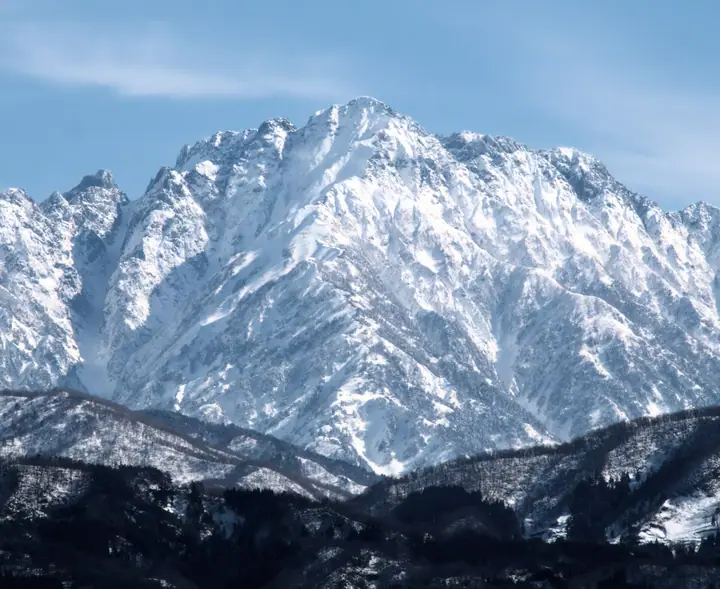
Mount Tsurugi is a 2,999 m peak on the boundary between Kamiichi and Tateyama in Toyama Prefecture, the principal summit of the northern Tateyama range. Within Chūbu-Sangaku National Park, it is celebrated as the "Cathedral of Rock and Snow" and is listed in Fukada Kyūya's Hyakumeizan and the Hyakkōzan. Long an object of mountain worship, the peak yielded a Nara-period shakujō head and an iron sword at the summit during its first surveyed ascent by the Imperial Japanese Army Land Survey in 1907. The two general routes — the Bessan Ridge from Murodo via Tsurugisawa, traversing the Kani-no-Tatebai and Yokobai chained pitches, and the Hayatsuki Ridge climbing directly from Babashima — both demand sustained chained-rock and ridge climbing and are suitable only for experienced alpinists.
Mount Tsurugi at a glance
- Weather: The most settled day in the next 7 days is Wed, November 4: clear, gusts up to 6 m/s. Fri, Nov 6, Sat, Nov 7: strong wind (gusts up to 20 m/s).
- Route: The shortest is Mount Tsurugi via Hayatsuki Ridge from Banbajima: about 12 h 3 min, 16.3 km, about 2,340 m of climbing.
Mount Tsurugi weather (hourly, 14 days)
Sunrise today 06:14, sunset 16:52
| Tue, 11/3 | Wed, 11/4 | Thu, 11/5 | Fri, 11/6 | Sat, 11/7 | Sun, 11/8 | Mon, 11/9 | Tue, 11/10 | Wed, 11/11 | Thu, 11/12 | Fri, 11/13 | Sat, 11/14 | Sun, 11/15 | Mon, 11/16 | Tue, 11/17 | |||||||||||||||||||||||||||||||||||||||||||||||||||||||||||||||||||||||
|---|---|---|---|---|---|---|---|---|---|---|---|---|---|---|---|---|---|---|---|---|---|---|---|---|---|---|---|---|---|---|---|---|---|---|---|---|---|---|---|---|---|---|---|---|---|---|---|---|---|---|---|---|---|---|---|---|---|---|---|---|---|---|---|---|---|---|---|---|---|---|---|---|---|---|---|---|---|---|---|---|---|---|---|---|---|
| Japan time | 15 | 17 | 19 | 21 | 23 | 1 | 3 | 5 | 7 | 9 | 11 | 13 | 15 | 18 | 21 | 0 | 3 | 6 | 9 | 12 | 15 | 18 | 21 | 0 | 3 | 6 | 9 | 12 | 15 | 18 | 21 | 0 | 3 | 6 | 9 | 12 | 15 | 18 | 21 | 0 | 3 | 6 | 9 | 12 | 15 | 18 | 21 | 0 | 3 | 6 | 9 | 15 | 21 | 3 | 9 | 15 | 21 | 3 | 9 | 15 | 21 | 3 | 9 | 15 | 21 | 3 | 9 | 15 | 21 | 3 | 9 | 15 | 21 | 3 | 9 | 15 | 21 | 3 | 9 | 15 | 21 | 3 | 9 | 15 | |
  |  |   | | |   | | |  | | | | |   | |   | | |   | |   | | | | | | | | | |   |   | | |   | | | | | | | | | | |   | | | | | | | |   | | | | | | | | | | | | | |   | |  | | | | | |   | | | |   | | | | | ||
| Temperature | °C | -4° | -8° | -11° | -14° | -14° | -13° | -12° | -11° | -10° | -3° | -1° | 0° | -1° | -5° | -5° | -5° | -5° | -4° | -1° | 2° | 2° | -1° | -2° | -2° | -3° | -3° | -4° | -4° | -5° | -7° | -9° | -10° | -12° | -12° | -13° | -13° | -13° | -14° | -15° | -17° | -18° | -19° | -10° | -8° | -9° | -11° | -12° | -11° | -11° | -10° | -7° | -7° | -15° | -18° | -6° | -5° | -10° | -15° | -13° | -12° | -14° | -17° | -9° | -9° | -17° | -11° | -10° | -10° | -16° | -18° | -6° | -4° | -12° | -12° | -3° | -3° | -4° | -4° | -5° | -8° | -12° | -16° | -8° | -7° |
| Precipitation | mm | 1.2 | 10 | 8 | 4.7 | 1.7 | 0.3 | 1.6 | 1.3 | 5 | 3.8 | 3.7 | 1.6 | 3.7 | 3.7 | 6 | 4.1 | 4.3 | 3.9 | 2.4 | 2.2 | 1.5 | 0.4 | 0.4 | 0.1 | 0.4 | 1.7 | 1.9 | 0.1 | 0.7 | 8 | 14 | 10 | 4.1 | 0.3 | 3.3 | 8 | 0.5 | 0.7 | 7 | 7 | 12 | 14 | 4.3 | |||||||||||||||||||||||||||||||||||||||||
| New snow | cm | 1.0 | 5.2 | 3.6 | 4.1 | 3.7 | 2.4 | 2.2 | 1.4 | 0.3 | 0.2 | <.1 | <.1 | 0.4 | 1.5 | 1.7 | 0.1 | 0.4 | 7.6 | 13 | 10 | 4.1 | 0.3 | <.1 | 3.2 | 6.7 | 0.5 | 0.7 | 2.0 | ||||||||||||||||||||||||||||||||||||||||||||||||||||||||
| Snow depth | cm | 0 | 0 | 0 | 0 | 0 | 0 | 0 | 0 | 0 | 0 | 0 | 0 | 0 | 0 | 0 | 0 | 0 | 0 | 0 | 0 | 0 | 0 | 0 | 0 | 0 | 0 | 0 | 0 | 0 | 0 | <1 | 4 | 7 | 10 | 12 | 13 | 15 | 15 | 16 | 16 | 15 | 15 | 15 | 14 | 14 | 13 | 13 | 13 | 14 | 16 | 15 | 14 | 13 | 13 | 13 | 11 | 16 | 26 | 33 | 34 | 33 | 32 | 32 | 31 | 30 | 32 | 36 | 35 | 34 | 34 | 33 | 32 | 32 | 32 | 31 | 29 | 28 | 26 | 24 | 21 | 22 | 22 | 21 | 20 |
| Wind | m/s | 2 | 1 | 0 | 1 | 0 | 0 | 0 | 0 | 0 | 1 | 0 | 1 | 1 | 1 | 2 | 0 | 1 | 1 | 1 | 2 | 2 | 0 | 1 | 1 | 1 | 2 | 3 | 3 | 3 | 3 | 4 | 3 | 4 | 4 | 4 | 4 | 3 | 2 | 1 | 1 | 1 | 1 | 1 | 2 | 0 | 1 | 1 | 1 | 0 | 0 | 1 | 1 | 1 | 0 | 1 | 3 | 3 | 7 | 5 | 2 | 0 | 1 | 1 | 2 | 1 | 2 | 3 | 1 | 0 | 0 | 0 | 0 | 0 | 1 | 0 | 1 | 1 | 2 | 2 | 3 | 1 | 1 | 1 | 1 |
| Wind gusts | m/s | 9 | 9 | 7 | 6 | 6 | 6 | 5 | 5 | 4 | 6 | 6 | 5 | 5 | 6 | 9 | 9 | 7 | 7 | 10 | 12 | 13 | 10 | 8 | 10 | 9 | 11 | 14 | 15 | 18 | 17 | 18 | 17 | 19 | 19 | 19 | 20 | 19 | 16 | 13 | 11 | 10 | 10 | 9 | 10 | 10 | 8 | 8 | 9 | 9 | 9 | 10 | 10 | 8 | 5 | 5 | 15 | 16 | 30 | 30 | 21 | 12 | 5 | 7 | 10 | 9 | 10 | 12 | 12 | 9 | 7 | 5 | 7 | 5 | 6 | 7 | 14 | 18 | 17 | 14 | 16 | 16 | 7 | 5 | 6 |
| Wind dir. | ↓ | ↓ | ↓ | ↓ | ↓ | ↓ | ↓ | ↓ | ↓ | ↓ | ↓ | ↓ | ↓ | ↓ | ↓ | ↓ | ↓ | ↓ | ↓ | ↓ | ↓ | ↓ | ↓ | ↓ | ↓ | ↓ | ↓ | ↓ | ↓ | ↓ | ↓ | ↓ | ↓ | ↓ | ↓ | ↓ | ↓ | ↓ | ↓ | ↓ | ↓ | ↓ | ↓ | ↓ | ↓ | ↓ | ↓ | ↓ | ↓ | ↓ | ↓ | ↓ | ↓ | ↓ | ↓ | ↓ | ↓ | ↓ | ↓ | ↓ | ↓ | ↓ | ↓ | ↓ | ↓ | ↓ | ↓ | ↓ | ↓ | ↓ | ↓ | ↓ | ↓ | ↓ | ↓ | ↓ | ↓ | ↓ | ↓ | ↓ | ↓ | ↓ | ↓ | ↓ | |
Mount Tsurugi hiking routes
- Mount Tsurugi via Hayatsuki Ridge from Banbajima 16.3 km · Ascent 2,340 m parking
- Murodo–Tateyama Traverse and Mount Tsurugi Betsusan Ridge Circuit 18.5 km · Ascent 2,129 m Murodō (Bus station)
Hiking times are estimates calculated from the terrain.
Huts, campsites and lodging near Mount Tsurugi
Mountain huts
- Kenzan-so 2026: open July 1–October 4 · reservation required · sleeps 150
- Hayatsuki Goya 2026: open July 17–October 4 · reservation required
- Tsurugisawa-goya 2026: open July 10–October 4 · reservation required · sleeps 56
- 真砂沢ロッジ 2026: open July 17–October 11 · reservation required · sleeps 16
- 真砂沢口小屋
Campsites
- 早月小屋テント場
- Tsurugisawa Campsite
- Raicho-zawa Camping Site
Lists that include Mount Tsurugi
100 Famous Japanese Mountains · Japan 200 Famous Mountains · Japan's 300 Famous Mountains · Japan's 100 Highest Mountains · New Japan 100 Famous Mountains · 100 Famous Hot Spring Mountains · 100 Mountains of Hokuriku · 100 Mountains of Toyama · Elevations of 1003 Mountains of Japan · 1000 Mountains of Japan
Mount Tsurugi facts
- Also known as
- 劔岳 · 剣岳
- Elevation
- 2,999 m
- Location
- Tateyama, Toyama / Kamiichi, Toyama
36.623342, 137.617155 - National Park
- 中部山岳国立公園
- Website
- www.town.kamiichi.toyama.jp
- Trail Map
- www.pref.toyama.jp (PDF)
- Access Information
- www.town.kamiichi.toyama.jp
- Wikipedia
- ja.wikipedia.org