
Mae-Tsurugi
前剱
Tateyama, Toyama · Elevation 2,813 m
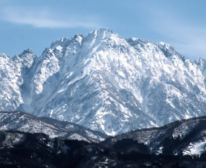
Mae-Tsurugi is a 2,813 m peak in Ashikuraji, Tateyama Town, Nakaniikawa District, Toyama Prefecture, on the southern ridge of Mt. Tsurugi (2,999 m) at the northern end of the Tateyama Range within Chūbu Sangaku National Park. On the standard Bessan-Ridge ascent of Mt. Tsurugi it lies just past Ippuku-Tsurugi and is reached after the fourth chain pitch. The peak forms one of the key way-points on the chain-and-ladder rocky ridge leading to the main summit. It is listed among the 642 Japanese Peaks Over 2000 m.
Mae-Tsurugi at a glance
- Weather: The most settled day in the next 7 days is Wed, November 4: clear, gusts up to 6 m/s. Fri, Nov 6, Sat, Nov 7: strong wind (gusts up to 20 m/s).
- Route: The shortest is Murodo–Tateyama Traverse and Mount Tsurugi Betsusan Ridge Circuit: about 12 h 38 min, 18.5 km, about 2,130 m of climbing.
Mae-Tsurugi weather (hourly, 14 days)
Sunrise today 06:14, sunset 16:52
| Tue, 11/3 | Wed, 11/4 | Thu, 11/5 | Fri, 11/6 | Sat, 11/7 | Sun, 11/8 | Mon, 11/9 | Tue, 11/10 | Wed, 11/11 | Thu, 11/12 | Fri, 11/13 | Sat, 11/14 | Sun, 11/15 | Mon, 11/16 | Tue, 11/17 | |||||||||||||||||||||||||||||||||||||||||||||||||||||||||||||||||||||||
|---|---|---|---|---|---|---|---|---|---|---|---|---|---|---|---|---|---|---|---|---|---|---|---|---|---|---|---|---|---|---|---|---|---|---|---|---|---|---|---|---|---|---|---|---|---|---|---|---|---|---|---|---|---|---|---|---|---|---|---|---|---|---|---|---|---|---|---|---|---|---|---|---|---|---|---|---|---|---|---|---|---|---|---|---|---|
| Japan time | 15 | 17 | 19 | 21 | 23 | 1 | 3 | 5 | 7 | 9 | 11 | 13 | 15 | 18 | 21 | 0 | 3 | 6 | 9 | 12 | 15 | 18 | 21 | 0 | 3 | 6 | 9 | 12 | 15 | 18 | 21 | 0 | 3 | 6 | 9 | 12 | 15 | 18 | 21 | 0 | 3 | 6 | 9 | 12 | 15 | 18 | 21 | 0 | 3 | 6 | 9 | 15 | 21 | 3 | 9 | 15 | 21 | 3 | 9 | 15 | 21 | 3 | 9 | 15 | 21 | 3 | 9 | 15 | 21 | 3 | 9 | 15 | 21 | 3 | 9 | 15 | 21 | 3 | 9 | 15 | 21 | 3 | 9 | 15 | |
  |  |   | | |   | | |  | | | | |   | |   | | |   | |   | | | | | | | | | |   |   | | |   | | | | | | | | | | |   | | | | | | | |   | | | | | | | | | | | | | |   | |  | | | | | |   | | | |   | | | | | ||
| Temperature | °C | -3° | -7° | -10° | -12° | -13° | -12° | -11° | -10° | -8° | -2° | 0° | 1° | 1° | -4° | -4° | -4° | -3° | -3° | 0° | 3° | 4° | 0° | -1° | -1° | -1° | -2° | -2° | -3° | -4° | -6° | -8° | -9° | -11° | -11° | -11° | -12° | -12° | -12° | -14° | -16° | -17° | -17° | -8° | -7° | -7° | -10° | -11° | -10° | -10° | -9° | -6° | -6° | -13° | -17° | -5° | -4° | -8° | -14° | -12° | -11° | -13° | -16° | -8° | -8° | -16° | -10° | -9° | -9° | -15° | -17° | -5° | -3° | -11° | -11° | -2° | -2° | -3° | -3° | -3° | -7° | -11° | -15° | -7° | -6° |
| Precipitation | mm | 1.2 | 10 | 8 | 4.7 | 1.7 | 0.3 | 1.6 | 1.3 | 5 | 3.8 | 3.7 | 1.6 | 3.7 | 3.7 | 6 | 4.1 | 4.3 | 3.9 | 2.4 | 2.2 | 1.5 | 0.4 | 0.4 | 0.1 | 0.4 | 1.7 | 1.9 | 0.1 | 0.7 | 8 | 14 | 10 | 4.1 | 0.3 | 3.3 | 8 | 0.5 | 0.7 | 7 | 7 | 12 | 14 | 4.3 | |||||||||||||||||||||||||||||||||||||||||
| New snow | cm | 1.0 | 5.2 | 3.6 | 4.1 | 3.7 | 2.4 | 2.2 | 1.4 | 0.3 | 0.2 | <.1 | <.1 | 0.4 | 1.5 | 1.7 | 0.1 | 0.4 | 7.6 | 13 | 10 | 4.1 | 0.3 | <.1 | 3.2 | 6.7 | 0.5 | 0.7 | 2.0 | ||||||||||||||||||||||||||||||||||||||||||||||||||||||||
| Snow depth | cm | 0 | 0 | 0 | 0 | 0 | 0 | 0 | 0 | 0 | 0 | 0 | 0 | 0 | 0 | 0 | 0 | 0 | 0 | 0 | 0 | 0 | 0 | 0 | 0 | 0 | 0 | 0 | 0 | 0 | 0 | <1 | 4 | 7 | 10 | 12 | 13 | 15 | 15 | 16 | 16 | 15 | 15 | 15 | 14 | 14 | 13 | 13 | 13 | 14 | 16 | 15 | 14 | 13 | 13 | 13 | 11 | 16 | 26 | 33 | 34 | 33 | 32 | 32 | 31 | 30 | 32 | 36 | 35 | 34 | 34 | 33 | 32 | 32 | 32 | 31 | 29 | 28 | 26 | 24 | 21 | 22 | 22 | 21 | 20 |
| Wind | m/s | 2 | 1 | 0 | 1 | 0 | 0 | 0 | 0 | 0 | 1 | 0 | 1 | 1 | 1 | 2 | 0 | 1 | 1 | 1 | 2 | 2 | 0 | 1 | 1 | 1 | 2 | 3 | 3 | 3 | 3 | 4 | 3 | 4 | 4 | 4 | 4 | 3 | 2 | 1 | 1 | 1 | 1 | 1 | 2 | 0 | 1 | 1 | 1 | 0 | 0 | 1 | 1 | 1 | 0 | 1 | 3 | 3 | 7 | 5 | 2 | 0 | 1 | 1 | 2 | 1 | 2 | 3 | 1 | 0 | 0 | 0 | 0 | 0 | 1 | 0 | 1 | 1 | 2 | 2 | 3 | 1 | 1 | 1 | 1 |
| Wind gusts | m/s | 9 | 9 | 7 | 6 | 6 | 6 | 5 | 5 | 4 | 6 | 6 | 5 | 5 | 6 | 9 | 9 | 7 | 7 | 10 | 12 | 13 | 10 | 8 | 10 | 9 | 11 | 14 | 15 | 18 | 17 | 18 | 17 | 19 | 19 | 19 | 20 | 19 | 16 | 13 | 11 | 10 | 10 | 9 | 10 | 10 | 8 | 8 | 9 | 9 | 9 | 10 | 10 | 8 | 5 | 5 | 15 | 16 | 30 | 30 | 21 | 12 | 5 | 7 | 10 | 9 | 10 | 12 | 12 | 9 | 7 | 5 | 7 | 5 | 6 | 7 | 14 | 18 | 17 | 14 | 16 | 16 | 7 | 5 | 6 |
| Wind dir. | ↓ | ↓ | ↓ | ↓ | ↓ | ↓ | ↓ | ↓ | ↓ | ↓ | ↓ | ↓ | ↓ | ↓ | ↓ | ↓ | ↓ | ↓ | ↓ | ↓ | ↓ | ↓ | ↓ | ↓ | ↓ | ↓ | ↓ | ↓ | ↓ | ↓ | ↓ | ↓ | ↓ | ↓ | ↓ | ↓ | ↓ | ↓ | ↓ | ↓ | ↓ | ↓ | ↓ | ↓ | ↓ | ↓ | ↓ | ↓ | ↓ | ↓ | ↓ | ↓ | ↓ | ↓ | ↓ | ↓ | ↓ | ↓ | ↓ | ↓ | ↓ | ↓ | ↓ | ↓ | ↓ | ↓ | ↓ | ↓ | ↓ | ↓ | ↓ | ↓ | ↓ | ↓ | ↓ | ↓ | ↓ | ↓ | ↓ | ↓ | ↓ | ↓ | ↓ | ↓ | |
Mae-Tsurugi hiking routes
Hiking times are estimates calculated from the terrain.
Huts, campsites and lodging near Mae-Tsurugi
Mountain huts
- Kenzan-so 2026: open July 1–October 4 · reservation required · sleeps 150
- Tsurugisawa-goya 2026: open July 10–October 4 · reservation required · sleeps 56
- Hayatsuki Goya 2026: open July 17–October 4 · reservation required
- Tsurugigozen-goya 2026: open April 28–October 17 · reservation required · sleeps 120
- 真砂沢ロッジ 2026: open July 17–October 11 · reservation required · sleeps 16
Campsites
- Tsurugisawa Campsite
- 早月小屋テント場
- Raicho-zawa Camping Site
Lodging
- Tatehama Kogen Hotel
Mae-Tsurugi facts
- Elevation
- 2,813 m
- Location
- Tateyama, Toyama
36.616634, 137.614961 - National Park
- 中部山岳国立公園
- Website
- www.pref.toyama.jp
- Trail Map
- www.pref.toyama.jp (PDF)
- Wikipedia
- ja.wikipedia.org