
Mount Tateyama
立山
Tateyama, Toyama · Elevation 3,015 m
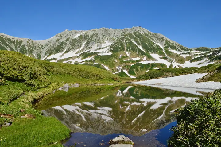
Mount Tateyama, in Tateyama Town, Toyama Prefecture, is a major mountain of the northern Hida Mountains comprising Oyama, Onanjiyama and Fuji-no-Oritate. Its highest point, Onanjiyama, reaches 3015 meters. Revered since antiquity, it is home to Oyama Shrine on Oyama. A centerpiece of Chubu Sangaku National Park, it is accessed from Murodo via the Tateyama Kurobe Alpine Route and is popular as a comparatively accessible climb, including for beginners.
Mount Tateyama at a glance
- Weather: The most settled day in the next 7 days is Wed, November 4: clear, gusts up to 7 m/s. Fri, Nov 6, Sat, Nov 7: strong wind (gusts up to 20 m/s).
- Route: The shortest is Mount Tate Loop via Oyama, Onanjiyama, and Fuji-no-Oritate: about 5 h 28 min, 8.4 km, about 840 m of climbing.
Mount Tateyama weather (hourly, 14 days)
Sunrise today 06:14, sunset 16:52
| Tue, 11/3 | Wed, 11/4 | Thu, 11/5 | Fri, 11/6 | Sat, 11/7 | Sun, 11/8 | Mon, 11/9 | Tue, 11/10 | Wed, 11/11 | Thu, 11/12 | Fri, 11/13 | Sat, 11/14 | Sun, 11/15 | Mon, 11/16 | Tue, 11/17 | |||||||||||||||||||||||||||||||||||||||||||||||||||||||||||||||||||||||
|---|---|---|---|---|---|---|---|---|---|---|---|---|---|---|---|---|---|---|---|---|---|---|---|---|---|---|---|---|---|---|---|---|---|---|---|---|---|---|---|---|---|---|---|---|---|---|---|---|---|---|---|---|---|---|---|---|---|---|---|---|---|---|---|---|---|---|---|---|---|---|---|---|---|---|---|---|---|---|---|---|---|---|---|---|---|
| Japan time | 21 | 23 | 1 | 3 | 5 | 7 | 9 | 11 | 13 | 15 | 17 | 19 | 21 | 0 | 3 | 6 | 9 | 12 | 15 | 18 | 21 | 0 | 3 | 6 | 9 | 12 | 15 | 18 | 21 | 0 | 3 | 6 | 9 | 12 | 15 | 18 | 21 | 0 | 3 | 6 | 9 | 12 | 15 | 18 | 21 | 0 | 3 | 6 | 9 | 12 | 15 | 21 | 3 | 9 | 15 | 21 | 3 | 9 | 15 | 21 | 3 | 9 | 15 | 21 | 3 | 9 | 15 | 21 | 3 | 9 | 15 | 21 | 3 | 9 | 15 | 21 | 3 | 9 | 15 | 21 | 3 | 9 | 15 | 21 | |
  | | | |  |   |  | | | |   |   | |   | | |   |   | | | | | | | | | |   |   | | | |   | | | | | | |   | | |   | | | | | | | | | |   | | | | | | |   |  | | | | | |   | | | | | | | | | | | |   | | | | | | ||
| Temperature | °C | -13° | -11° | -11° | -10° | -10° | -9° | -2° | 1° | 2° | 1° | -3° | -4° | -3° | -3° | -3° | -1° | 2° | 4° | 3° | 0° | 0° | -1° | -2° | -3° | -3° | -3° | -4° | -6° | -8° | -9° | -11° | -12° | -11° | -11° | -12° | -14° | -14° | -15° | -15° | -15° | -7° | -5° | -5° | -10° | -9° | -8° | -7° | -6° | -4° | -4° | -7° | -16° | -16° | -6° | -5° | -8° | -14° | -11° | -10° | -13° | -16° | -7° | -6° | -16° | -10° | -9° | -8° | -14° | -15° | -4° | -2° | -12° | -12° | -2° | -3° | -3° | -4° | -3° | -6° | -11° | -14° | -6° | -5° | -12° |
| Precipitation | mm | 3.6 | 9 | 5.0 | 0.1 | 1.0 | 0.2 | 2.1 | 10 | 4.8 | 1.2 | 1.9 | 1.4 | 3.4 | 2.6 | 2.6 | 2.9 | 2.9 | 2.5 | 2.3 | 1.4 | 0.4 | 0.2 | 0.1 | 0.1 | 4.9 | 11 | 8 | 2.7 | 2.4 | 5 | 0.3 | 0.7 | 8 | 8 | 6 | 9 | 4.2 | |||||||||||||||||||||||||||||||||||||||||||||||
| New snow | cm | 0.9 | 2.1 | 2.4 | 2.6 | 2.8 | 2.5 | 2.3 | 1.4 | 0.4 | 0.2 | <.1 | <.1 | <.1 | <.1 | 0.6 | <.1 | 4.8 | 10 | 8.2 | 2.7 | <.1 | 2.3 | 4.7 | 0.3 | 2.1 | 3.3 | ||||||||||||||||||||||||||||||||||||||||||||||||||||||||||
| Snow depth | cm | 0 | 0 | 0 | 0 | 0 | 0 | 0 | 0 | 0 | 0 | 0 | 0 | 0 | 0 | 0 | 0 | 0 | 0 | 0 | 0 | 0 | 0 | 0 | 0 | 0 | 0 | 0 | 0 | <1 | 4 | 6 | 9 | 12 | 13 | 14 | 14 | 13 | 13 | 13 | 12 | 12 | 12 | 11 | 11 | 11 | 11 | 12 | 14 | 14 | 14 | 12 | 12 | 12 | 12 | 11 | 14 | 23 | 29 | 30 | 29 | 28 | 28 | 27 | 26 | 28 | 31 | 30 | 30 | 29 | 29 | 28 | 28 | 28 | 27 | 25 | 24 | 22 | 20 | 19 | 21 | 20 | 20 | 20 | 19 |
| Wind | m/s | 1 | 1 | 1 | 0 | 0 | 1 | 1 | 0 | 1 | 1 | 1 | 1 | 1 | 0 | 0 | 2 | 2 | 2 | 1 | 1 | 2 | 3 | 2 | 3 | 3 | 4 | 3 | 4 | 3 | 3 | 3 | 4 | 4 | 5 | 4 | 3 | 2 | 2 | 1 | 1 | 1 | 1 | 0 | 1 | 1 | 1 | 1 | 2 | 2 | 2 | 1 | 1 | 1 | 1 | 2 | 3 | 7 | 4 | 2 | 1 | 1 | 1 | 1 | 1 | 2 | 2 | 1 | 1 | 1 | 1 | 0 | 1 | 1 | 1 | 1 | 2 | 2 | 1 | 3 | 1 | 0 | 0 | 0 | 0 |
| Wind gusts | m/s | 8 | 8 | 7 | 6 | 6 | 5 | 6 | 6 | 7 | 7 | 6 | 7 | 8 | 8 | 6 | 12 | 12 | 10 | 10 | 9 | 11 | 15 | 15 | 13 | 15 | 18 | 20 | 18 | 18 | 16 | 14 | 17 | 18 | 19 | 20 | 18 | 14 | 12 | 11 | 11 | 9 | 7 | 7 | 7 | 9 | 11 | 12 | 13 | 13 | 13 | 12 | 8 | 7 | 7 | 12 | 14 | 28 | 30 | 19 | 11 | 6 | 7 | 9 | 7 | 11 | 11 | 11 | 9 | 8 | 6 | 6 | 6 | 8 | 9 | 13 | 15 | 18 | 14 | 15 | 14 | 7 | 4 | 5 | 6 |
| Wind dir. | ↓ | ↓ | ↓ | ↓ | ↓ | ↓ | ↓ | ↓ | ↓ | ↓ | ↓ | ↓ | ↓ | ↓ | ↓ | ↓ | ↓ | ↓ | ↓ | ↓ | ↓ | ↓ | ↓ | ↓ | ↓ | ↓ | ↓ | ↓ | ↓ | ↓ | ↓ | ↓ | ↓ | ↓ | ↓ | ↓ | ↓ | ↓ | ↓ | ↓ | ↓ | ↓ | ↓ | ↓ | ↓ | ↓ | ↓ | ↓ | ↓ | ↓ | ↓ | ↓ | ↓ | ↓ | ↓ | ↓ | ↓ | ↓ | ↓ | ↓ | ↓ | ↓ | ↓ | ↓ | ↓ | ↓ | ↓ | ↓ | ↓ | ↓ | ↓ | ↓ | ↓ | ↓ | ↓ | ↓ | ↓ | ↓ | ↓ | ↓ | ↓ | ↓ | ↓ | ↓ | |
Mount Tateyama live cameras
Mount Tateyama hiking routes
- Mount Tate Loop via Oyama, Onanjiyama, and Fuji-no-Oritate 8.4 km · Ascent 836 m Murodō (Bus station)
- Mount Oyama–Bessan Circuit from Murodo 10.7 km · Ascent 1,057 m Murodō (Bus station)
- Murodo–Tateyama Traverse and Mount Tsurugi Betsusan Ridge Circuit 18.5 km · Ascent 2,129 m Murodō (Bus station)
Hiking times are estimates calculated from the terrain.
Huts, campsites and lodging near Mount Tateyama
Mountain huts
- 大汝休憩所 2026: open July 4–October 4
- Ichinokoshi Sanso 2026: open April 25–October 17 · reservation required · sleeps 130
- Kuranosuke Sanso 2026: open July 16–September 30 · reservation required · sleeps 40
- Tateyama Murodo Sanso 2026: open April 15–November 23 · reservation required · sleeps 100
- Raicho Onsen Raicho-so 2026: open April 15–November 24 · reservation required
Campsites
- Raicho-zawa Camping Site
- Tsurugisawa Campsite
- Kurojon
- 五色ヶ原山荘テント場
Lodging
- Tatehama Kogen Hotel
Lists that include Mount Tateyama
100 Famous Japanese Mountains · Japan 200 Famous Mountains · Japan's 300 Famous Mountains · 100 Famous Mountains of Flowers · Japan's 100 Highest Mountains · New Japan 100 Famous Mountains · Highest Peaks by Prefecture · Japan's 3000 m Peaks · Illustrated Collection of Japan's Famous Mountains · 100 Famous Hot Spring Mountains · Three Holy Mountains of Japan · 100 Mountains of Hokuriku · 100 Mountains of Toyama · Elevations of 1003 Mountains of Japan · 1000 Mountains of Japan
Mount Tateyama facts
- Also known as
- 大汝山 · 雄山 · 富士ノ折立 · Mount Tate
- Elevation
- 3,015 m
- Location
- Tateyama, Toyama
36.575999, 137.619907 - National Park
- 中部山岳国立公園
- Website
- www.town.tateyama.toyama.jp
- Trail Map
- www.pref.toyama.jp (PDF)
- Access Information
- tateyama-kurobe.com
- Wikipedia
- ja.wikipedia.org