
Mount Jodo
浄土山
Tateyama, Toyama · Elevation 2,831 m
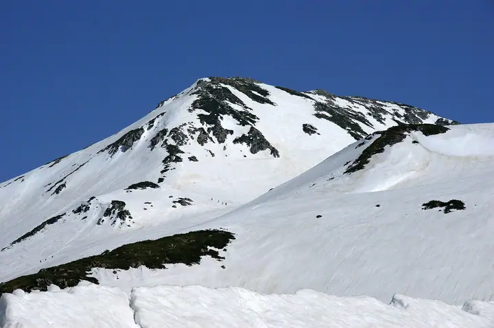
Mount Jodo is a 2831-meter mountain in Tateyama, Nakaniikawa District, Toyama Prefecture, on the main Tateyama ridge within Chubu Sangaku National Park. It is climbed from Murodo on the Tateyama Kurobe Alpine Route via Murodoyama. Alpine plants abound near the summit, and a University of Toyama research station stands near the southern peak. Trails branch there toward Ichinokoshi and Goshikigahara.
Mount Jodo at a glance
- Weather: The most settled day in the next 7 days is Wed, November 4: clear, gusts up to 6 m/s. Fri, Nov 6, Sat, Nov 7: strong wind (gusts up to 21 m/s).
Mount Jodo weather (hourly, 14 days)
Sunrise today 06:14, sunset 16:52
| Tue, 11/3 | Wed, 11/4 | Thu, 11/5 | Fri, 11/6 | Sat, 11/7 | Sun, 11/8 | Mon, 11/9 | Tue, 11/10 | Wed, 11/11 | Thu, 11/12 | Fri, 11/13 | Sat, 11/14 | Sun, 11/15 | Mon, 11/16 | Tue, 11/17 | |||||||||||||||||||||||||||||||||||||||||||||||||||||||||||||||||||||||
|---|---|---|---|---|---|---|---|---|---|---|---|---|---|---|---|---|---|---|---|---|---|---|---|---|---|---|---|---|---|---|---|---|---|---|---|---|---|---|---|---|---|---|---|---|---|---|---|---|---|---|---|---|---|---|---|---|---|---|---|---|---|---|---|---|---|---|---|---|---|---|---|---|---|---|---|---|---|---|---|---|---|---|---|---|---|
| Japan time | 15 | 17 | 19 | 21 | 23 | 1 | 3 | 5 | 7 | 9 | 11 | 13 | 15 | 18 | 21 | 0 | 3 | 6 | 9 | 12 | 15 | 18 | 21 | 0 | 3 | 6 | 9 | 12 | 15 | 18 | 21 | 0 | 3 | 6 | 9 | 12 | 15 | 18 | 21 | 0 | 3 | 6 | 9 | 12 | 15 | 18 | 21 | 0 | 3 | 6 | 9 | 15 | 21 | 3 | 9 | 15 | 21 | 3 | 9 | 15 | 21 | 3 | 9 | 15 | 21 | 3 | 9 | 15 | 21 | 3 | 9 | 15 | 21 | 3 | 9 | 15 | 21 | 3 | 9 | 15 | 21 | 3 | 9 | 15 | |
 |   | |  | | | | |   | | | | |   | |   | | |   | |   | | | | | | | | |   | |   | | |   | | | | | |   | | | |   |   | | | | | | | |   | | | | | | | |  | | | | | |   | | | | | | | | | | | |   | | | | | ||
| Temperature | °C | -2° | -7° | -9° | -10° | -10° | -10° | -9° | -8° | -7° | 0° | 2° | 3° | 2° | -3° | -2° | -2° | -2° | -1° | 1° | 4° | 5° | 1° | 0° | 0° | 0° | -1° | -1° | -2° | -2° | -4° | -6° | -8° | -10° | -11° | -10° | -10° | -11° | -13° | -14° | -16° | -17° | -14° | -6° | -4° | -5° | -8° | -8° | -8° | -8° | -7° | -5° | -5° | -15° | -15° | -4° | -4° | -7° | -13° | -10° | -9° | -12° | -15° | -6° | -5° | -14° | -8° | -7° | -7° | -13° | -14° | -3° | -1° | -11° | -11° | -1° | -1° | -2° | -2° | -2° | -5° | -10° | -13° | -5° | -3° |
| Precipitation | mm | 2.2 | 10 | 8 | 5 | 1.6 | 1.1 | 1.4 | 4.1 | 2.1 | 2.3 | 0.9 | 2.3 | 1.8 | 4.6 | 3.6 | 3.7 | 3.4 | 1.9 | 1.0 | 0.5 | 0.4 | 1.6 | 2.0 | 0.2 | 0.6 | 4.9 | 11 | 8 | 2.7 | 2.4 | 5 | 0.3 | 0.7 | 8 | 8 | 6 | 9 | 4.2 | ||||||||||||||||||||||||||||||||||||||||||||||
| New snow | cm | 0.2 | 0.9 | 4.3 | 3.5 | 3.6 | 3.3 | 1.9 | 1.0 | 0.5 | <.1 | <.1 | <.1 | 0.4 | 1.6 | 1.9 | 0.2 | 0.6 | <.1 | 4.8 | 10 | 8.2 | 2.7 | <.1 | 2.3 | 4.7 | 0.3 | 2.1 | 3.3 | ||||||||||||||||||||||||||||||||||||||||||||||||||||||||
| Snow depth | cm | 0 | 0 | 0 | 0 | 0 | 0 | 0 | 0 | 0 | 0 | 0 | 0 | 0 | 0 | 0 | 0 | 0 | 0 | 0 | 0 | 0 | 0 | 0 | 0 | 0 | 0 | 0 | 0 | 0 | 0 | <1 | 4 | 6 | 9 | 12 | 13 | 14 | 14 | 13 | 13 | 13 | 12 | 12 | 12 | 11 | 11 | 11 | 11 | 12 | 14 | 14 | 12 | 12 | 12 | 12 | 11 | 14 | 23 | 29 | 30 | 29 | 28 | 28 | 27 | 26 | 28 | 31 | 30 | 30 | 29 | 29 | 28 | 28 | 28 | 27 | 25 | 24 | 22 | 20 | 19 | 21 | 20 | 20 | 20 |
| Wind | m/s | 1 | 1 | 1 | 1 | 1 | 1 | 0 | 0 | 0 | 1 | 0 | 1 | 1 | 1 | 2 | 0 | 0 | 1 | 2 | 3 | 3 | 0 | 1 | 2 | 1 | 2 | 3 | 4 | 3 | 4 | 4 | 3 | 4 | 4 | 4 | 5 | 3 | 2 | 2 | 2 | 1 | 1 | 1 | 2 | 0 | 1 | 1 | 1 | 1 | 2 | 2 | 1 | 1 | 1 | 1 | 2 | 3 | 7 | 4 | 2 | 1 | 1 | 1 | 1 | 1 | 2 | 2 | 1 | 1 | 1 | 1 | 0 | 1 | 1 | 1 | 1 | 2 | 2 | 1 | 3 | 1 | 0 | 0 | 0 |
| Wind gusts | m/s | 10 | 8 | 8 | 8 | 8 | 7 | 6 | 6 | 5 | 6 | 6 | 6 | 6 | 7 | 9 | 9 | 6 | 7 | 12 | 15 | 14 | 11 | 8 | 11 | 10 | 11 | 14 | 16 | 19 | 17 | 17 | 16 | 18 | 18 | 18 | 21 | 20 | 16 | 13 | 12 | 12 | 11 | 10 | 9 | 9 | 9 | 9 | 10 | 11 | 11 | 11 | 11 | 8 | 7 | 7 | 12 | 14 | 28 | 30 | 19 | 11 | 6 | 7 | 9 | 7 | 11 | 11 | 11 | 9 | 8 | 6 | 6 | 6 | 8 | 9 | 13 | 15 | 18 | 14 | 15 | 14 | 7 | 4 | 5 |
| Wind dir. | ↓ | ↓ | ↓ | ↓ | ↓ | ↓ | ↓ | ↓ | ↓ | ↓ | ↓ | ↓ | ↓ | ↓ | ↓ | ↓ | ↓ | ↓ | ↓ | ↓ | ↓ | ↓ | ↓ | ↓ | ↓ | ↓ | ↓ | ↓ | ↓ | ↓ | ↓ | ↓ | ↓ | ↓ | ↓ | ↓ | ↓ | ↓ | ↓ | ↓ | ↓ | ↓ | ↓ | ↓ | ↓ | ↓ | ↓ | ↓ | ↓ | ↓ | ↓ | ↓ | ↓ | ↓ | ↓ | ↓ | ↓ | ↓ | ↓ | ↓ | ↓ | ↓ | ↓ | ↓ | ↓ | ↓ | ↓ | ↓ | ↓ | ↓ | ↓ | ↓ | ↓ | ↓ | ↓ | ↓ | ↓ | ↓ | ↓ | ↓ | ↓ | ↓ | ↓ | ↓ | |
Huts, campsites and lodging near Mount Jodo
Mountain huts
- Ichinokoshi Sanso 2026: open April 25–October 17 · reservation required · sleeps 130
- Tateyama Murodo Sanso 2026: open April 15–November 23 · reservation required · sleeps 100
- Mikuriga-ike Onsen 2026: open April 15–November 24 · reservation required
- 大汝休憩所 2026: open July 4–October 4
- Raicho Onsen Raicho-so 2026: open April 15–November 24 · reservation required
Campsites
- Raicho-zawa Camping Site
- 五色ヶ原山荘テント場
- Tsurugisawa Campsite
- Kurojon
Lodging
- Tatehama Kogen Hotel
- Midagahara Hotel
Lists that include Mount Jodo
100 Mountains of Toyama · Elevations of 1003 Mountains of Japan · 1000 Mountains of Japan
Mount Jodo facts
- Elevation
- 2,831 m
- Location
- Tateyama, Toyama
36.568464, 137.603722 - National Park
- 中部山岳国立公園
- Website
- www.alpen-route.com
- Access Information
- www.alpen-route.com
- Wikipedia
- ja.wikipedia.org