
Mt. Shiratake
白岳
Ōmachi-shi, Nagano · Elevation 2,541 m
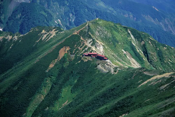
Mt. Shiratake is a 2,541-meter peak in the Ushiro-Tateyama Range of the Hida Mountains (Northern Alps), just north of Mt. Goryu on the border between Kurobe (Toyama) and Omachi (Nagano). The Tomimi-one ridge joins the main spine of the range here, and the saddle just below the summit holds Goryu-sanso lodge en route to Mt. Goryu and Mt. Karamatsu. The peak lies within Chubu Sangaku National Park.
Mt. Shiratake at a glance
- Weather: The most settled day in the next 7 days is Wed, November 4: clear, gusts up to 6 m/s. Fri, Nov 6, Sat, Nov 7: strong wind (gusts up to 18 m/s).
- Route: The shortest is Goryūdake via the Tōmi Ridge: about 9 h 56 min, 14.9 km, about 1,600 m of climbing.
Mt. Shiratake weather (hourly, 14 days)
Sunrise today 06:14, sunset 16:51
| Tue, 11/3 | Wed, 11/4 | Thu, 11/5 | Fri, 11/6 | Sat, 11/7 | Sun, 11/8 | Mon, 11/9 | Tue, 11/10 | Wed, 11/11 | Thu, 11/12 | Fri, 11/13 | Sat, 11/14 | Sun, 11/15 | Mon, 11/16 | Tue, 11/17 | |||||||||||||||||||||||||||||||||||||||||||||||||||||||||||||||||||||||
|---|---|---|---|---|---|---|---|---|---|---|---|---|---|---|---|---|---|---|---|---|---|---|---|---|---|---|---|---|---|---|---|---|---|---|---|---|---|---|---|---|---|---|---|---|---|---|---|---|---|---|---|---|---|---|---|---|---|---|---|---|---|---|---|---|---|---|---|---|---|---|---|---|---|---|---|---|---|---|---|---|---|---|---|---|---|
| Japan time | 15 | 17 | 19 | 21 | 23 | 1 | 3 | 5 | 7 | 9 | 11 | 13 | 15 | 18 | 21 | 0 | 3 | 6 | 9 | 12 | 15 | 18 | 21 | 0 | 3 | 6 | 9 | 12 | 15 | 18 | 21 | 0 | 3 | 6 | 9 | 12 | 15 | 18 | 21 | 0 | 3 | 6 | 9 | 12 | 15 | 18 | 21 | 0 | 3 | 6 | 9 | 15 | 21 | 3 | 9 | 15 | 21 | 3 | 9 | 15 | 21 | 3 | 9 | 15 | 21 | 3 | 9 | 15 | 21 | 3 | 9 | 15 | 21 | 3 | 9 | 15 | 21 | 3 | 9 | 15 | 21 | 3 | 9 | 15 | |
  |   |   | |  | | | | |  | | | | |   |   | | |   |   |   | | | | | | | | | |   | |   | |   | | | | | | | | | | |   | | | | | | | |   | | | | | | | | | | | | | |   | |  | | | | | | | | | |   | | | | | ||
| Temperature | °C | 2° | -1° | -5° | -8° | -9° | -8° | -7° | -6° | -4° | 1° | 4° | 5° | 4° | 0° | 0° | 0° | 0° | 1° | 3° | 6° | 8° | 4° | 4° | 3° | 3° | 2° | 3° | 3° | 2° | -1° | -2° | -4° | -5° | -6° | -7° | -7° | -7° | -8° | -9° | -11° | -12° | -12° | -4° | -1° | -2° | -5° | -6° | -5° | -5° | -4° | -1° | -2° | -7° | -10° | -2° | 1° | -4° | -9° | -6° | -5° | -8° | -11° | -4° | -2° | -11° | -5° | -4° | -3° | -10° | -13° | -1° | 2° | -7° | -7° | 1° | 2° | 1° | 0° | 1° | -2° | -6° | -9° | -3° | 0° |
| Precipitation | mm | 1.4 | 10 | 8 | 5 | 2.0 | 0.1 | 1.9 | 0.1 | 0.7 | 2.8 | 1.7 | 1.7 | 0.7 | 1.9 | 2.2 | 3.9 | 3.3 | 3.8 | 3.8 | 2.3 | 1.7 | 1.1 | 0.3 | 0.2 | 0.3 | 1.6 | 2.1 | 0.2 | 0.2 | 0.2 | 4.9 | 10 | 9 | 2.8 | 0.1 | 2.0 | 6 | 0.3 | 0.5 | 8 | 8 | 6 | 7 | 2.3 | ||||||||||||||||||||||||||||||||||||||||
| New snow | cm | 0.3 | 3.1 | 3.0 | 3.7 | 3.7 | 2.3 | 1.7 | 1.0 | 0.2 | 0.1 | <.1 | <.1 | 0.3 | 1.4 | 1.9 | 0.1 | <.1 | 4.1 | 9.8 | 9.3 | 2.8 | 0.1 | <.1 | 1.9 | 5.4 | 0.2 | 0.2 | 0.8 | ||||||||||||||||||||||||||||||||||||||||||||||||||||||||
| Snow depth | cm | 0 | 0 | 0 | 0 | 0 | 0 | 0 | 0 | 0 | 0 | 0 | 0 | 0 | 0 | 0 | 0 | 0 | 0 | 0 | 0 | 0 | 0 | 0 | 0 | 0 | 0 | 0 | 0 | 0 | 0 | <1 | 2 | 4 | 7 | 9 | 10 | 12 | 12 | 12 | 12 | 12 | 11 | 11 | 10 | 10 | 10 | 10 | 10 | 11 | 12 | 12 | 10 | 9 | 9 | 9 | 7 | 10 | 16 | 23 | 23 | 22 | 22 | 21 | 20 | 19 | 20 | 24 | 23 | 22 | 22 | 22 | 20 | 20 | 20 | 20 | 17 | 16 | 15 | 13 | 10 | 10 | 10 | 10 | 9 |
| Wind | m/s | 1 | 0 | 0 | 1 | 1 | 1 | 1 | 0 | 0 | 2 | 1 | 1 | 2 | 0 | 1 | 0 | 0 | 0 | 1 | 0 | 1 | 0 | 0 | 1 | 1 | 1 | 2 | 3 | 2 | 2 | 2 | 2 | 2 | 2 | 2 | 3 | 2 | 2 | 2 | 2 | 2 | 2 | 1 | 1 | 0 | 0 | 0 | 0 | 0 | 1 | 1 | 0 | 0 | 0 | 1 | 1 | 1 | 4 | 4 | 2 | 1 | 1 | 0 | 0 | 1 | 2 | 1 | 1 | 1 | 1 | 0 | 0 | 0 | 1 | 0 | 0 | 1 | 1 | 1 | 2 | 1 | 0 | 0 | 0 |
| Wind gusts | m/s | 9 | 7 | 6 | 7 | 7 | 7 | 6 | 5 | 4 | 6 | 6 | 6 | 6 | 6 | 7 | 8 | 5 | 6 | 9 | 10 | 9 | 8 | 6 | 8 | 7 | 9 | 12 | 15 | 18 | 15 | 15 | 15 | 16 | 15 | 15 | 18 | 18 | 15 | 13 | 12 | 12 | 12 | 10 | 8 | 8 | 7 | 7 | 7 | 8 | 8 | 8 | 9 | 6 | 5 | 5 | 10 | 12 | 25 | 26 | 20 | 11 | 6 | 6 | 7 | 7 | 10 | 10 | 11 | 9 | 7 | 6 | 5 | 5 | 6 | 6 | 9 | 11 | 12 | 11 | 14 | 14 | 7 | 4 | 4 |
| Wind dir. | ↓ | ↓ | ↓ | ↓ | ↓ | ↓ | ↓ | ↓ | ↓ | ↓ | ↓ | ↓ | ↓ | ↓ | ↓ | ↓ | ↓ | ↓ | ↓ | ↓ | ↓ | ↓ | ↓ | ↓ | ↓ | ↓ | ↓ | ↓ | ↓ | ↓ | ↓ | ↓ | ↓ | ↓ | ↓ | ↓ | ↓ | ↓ | ↓ | ↓ | ↓ | ↓ | ↓ | ↓ | ↓ | ↓ | ↓ | ↓ | ↓ | ↓ | ↓ | ↓ | ↓ | ↓ | ↓ | ↓ | ↓ | ↓ | ↓ | ↓ | ↓ | ↓ | ↓ | ↓ | ↓ | ↓ | ↓ | ↓ | ↓ | ↓ | ↓ | ↓ | ↓ | ↓ | ↓ | ↓ | ↓ | ↓ | ↓ | ↓ | ↓ | ↓ | ↓ | ↓ | |
Mt. Shiratake hiking routes
- Goryūdake via the Tōmi Ridge 14.9 km · Ascent 1,601 m
- Mount Karamatsu and Mount Goryu Traverse: Happoike Sanso to Alps-daira Station 17.7 km · Ascent 1,751 m グラートクワッドリフト 頂上駅 (Aerialway station)
- Mount Kashima-Yarigatake–Mount Goryu Happo Kiretto Traverse 24.2 km · Ascent 2,860 m 柏原新道登山口 (parking) → 五竜テレキャビン アルプス平駅 (Aerialway station)
Hiking times are estimates calculated from the terrain.
Huts, campsites and lodging near Mt. Shiratake
Mountain huts
- Goryusanso 2026: open June 20–October 12 · reservation required · sleeps 250
- 唐松岳頂上山荘 2026: open June 27–October 13 · reservation required · sleeps 350
- Kiret Goya 2026: open June 27–September 27 · reservation required · sleeps 80
- 法政大学遠見ヒュッテ unstaffed
- Happoike Sanso 2026: open all year · reservation required · sleeps 50
Campsites
- 唐松岳頂上山荘 テント場
Mt. Shiratake facts
- Elevation
- 2,541 m
- Location
- Ōmachi-shi, Nagano
36.664637, 137.760943 - National Park
- 中部山岳国立公園
- Season Opens
- June 20
- Season Closes
- October 12
- Website
- hakubakan.com
- Wikipedia
- ja.wikipedia.org